# Monday, 12 September 2011

Click
GOES-11 Water Vapor Image
Saturday September 10, 2011 - 6:30 pm PDT

A dynamic cutoff upper low centered over Southern California produced numerous thunderstorms in Southern California and a broad area of the southwestern U.S. Saturday. The thunderstorms produced thousands of lightning strikes, some heavy downpours, hail and strong winds.

According to an article on Yuba.net over 15,000 lightning strikes were recorded in California over the 24 hour period ending 0600 PDT Sunday. This plot of lightning detections was produced by Tahoe National Forest. (Typically lightning detections include both cloud-cloud and cloud-ground strokes.)

Thunderstorms were widespread in Southern California and several strong thunderstorms were reported by the NWS. This NWS NEXRAD image from about noon on Saturday shows several strong cells including one area flagged as severe. This composite image from WSI/Intellicast.com at 2:45 pm PDT shows estimated cloud tops, cell movement and hail. Half inch hail was reported in several locations by NWS spotters and there was one report of 1.25 inch hail near Lake Los Angeles. A wide swath of enhanced thunderstorm activity developed in the afternoon to the north and northeast of Los Angeles.

Some of the higher rainfall totals reported by the NWS include Lake Palmdale at 0.98 inch; Palmdale 0.84 inch and Lockwood Valley 0.58 inch. Downtown Los Angeles recorded a trace. Here's a NWS Los Angeles/Oxnard tabulation of some rainfall totals from around the area. Here also is a NWS San Joaquin Valley/Hanford tabulation of some rainfall totals in the southern San Joaquin Valley and Sierra.

In a Southern California Weathernotes post in February I commented that the tough question regarding La Niña was whether warming would continue into the NH summer, with neutral ENSO conditions prevailing as we move into autumn; or if the ENSO cycle would swing back toward a La Nina state. It was noted that since 1949, about half of the first year La Nina episodes have continued into a second or third year.

Climate scientist and Multivariate ENSO Index (MEI) codeveloper Klaus Wolter first mentioned the roughly 50/50 chance that La Nina would return following a summer respite in September 2010. A glance at a plot of the extended MEI index, going back to 1871 clearly shows a propensity for a return of La Nina in the year (or years) following stronger La Nina episodes.

In a September 8, 2011 press release NOAA reported that La Nina is back. More precisely, in their September 8 ENSO Diagnostic Discussion CPC states "La Niña conditions have returned and are expected to gradually strengthen and continue into the Northern Hemisphere winter 2011-12." The Multivariate ENSO Index (MEI) has dropped below the weak La Nina threshold, and several oceanic and atmospheric factors are indicative of a reemerging La Nina. There's still a (historically) slight chance of a return to ENSO neutral conditions this fall, but it doesn't appear likely. We'll see!

More information about Southern California weather and climate can be found using our WEATHER LINKS page.

Monday, 12 September 2011 13:39:58 (Pacific Daylight Time, UTC-07:00)  #    Disclaimer  |   | 
# Thursday, 30 June 2011

Click
GOES-11 Water Vapor Image
Tuesday June 28, 2011 - 2:30 pm PDT

Tuesday a front associated with an unseasonably strong Pacific low pressure system broke rainfall records in much of the northern half of the state. Precipitation records for the date were broken in numerous locations, including Monterey, San Jose, Oakland, San Francisco, Napa, Sacramento, Redding, Eureka and Crescent City. Here are archived copies of record reports from the San Francisco Bay/Monterey NWS Office and the Sacramento NWS Office.

The front and trough produced a few clouds and cooled temperatures in the Los Angeles area, but I didn't see any reports of rain. Downtown Los Angeles (USC) will end the July 1, 2010 to June 30, 2011 water year with 20.20 inches of rain. This is about 133% of the climate normal of 15.14 inches. According to NWS data Camarillo/Oxnard recorded 139% of normal rainfall, Long Beach 145%, Santa Barbara 169% and Palmdale 105%.

Looks like temperatures will be warming up for the July 4th weekend. Temperatures are expected to reach into the 80s at the coast, 90's inland and 100's in the valleys. Desert areas could reach 110 or higher. Models suggest the possibility of some monsoon moisture moving into the area Sunday or Monday, along with a chance of thunderstorms in the mountains and deserts. Check the NWS Los Angeles/Oxnard Office for the latest forecasts and warnings.

More information about Southern California weather and climate can be found using our WEATHER LINKS page.

Thursday, 30 June 2011 15:30:58 (Pacific Daylight Time, UTC-07:00)  #    Disclaimer  |   | 
# Tuesday, 07 June 2011

Click
Aqua-MODIS Composite Satellite Image (NRL)
Saturday, June 4, 2011

An unseasonably strong Pacific low pressure system that stalled about 200 NM off the Central Californio coast set new rainfall records from San Francisco to Santa Barbara over the weekend. The N-S oriented front associated with the system was positioned over Santa Barbara and San Luis Obispo counties much of the weekend, resulting in unusually high rainfall totals in some areas. Midday Sunday the upper low began to move east along 35°N, increasing divergence aloft in areas north of Pt. Conception and producing additional precipitation Sunday afternoon and evening.

Saturday a new rainfall record for the date was set in San Francisco; and on Saturday and Sunday new rainfall records were set in Stockton, Modesto, Paso Robles and Santa Maria. Sunday Santa Barbara Airport recorded 1.24 inches of rain, breaking the record for the date, and increasing the station's rainfall total for June to the highest since recordkeeping began in 1941. The dissipating front produced some scattered showers in the Los Angeles area Sunday.

There were some impressive storm totals. Nordhoff Ridge, in Ventura County, recorded 1.07 inches of rain; Refugio Pass, in Santa Barbara County, 2.64 inches; and Rocky Butte, in San Luis Obispo County, 3.94 inches. Downtown Los Angeles (USC) recorded a trace of rain on Sunday, leaving our water year (July 1 to June 30) rainfall total at 20.19 inches. Here is an archived copy of a NWS Los Angeles/Oxnard compilation of some rainfall totals from around the area.

Saturday I did a trail run on the 8000-9000 ft. ridge between Mt. Pinos and Mt. Abel, north of Los Angeles, and was able to observe first-hand the very strong southerly flow associated with this system, and the spectacular wave clouds that resulted.

More information about Southern California weather and climate can be found using our WEATHER LINKS page.

Tuesday, 07 June 2011 11:43:44 (Pacific Daylight Time, UTC-07:00)  #    Disclaimer  |   | 
# Monday, 16 May 2011

Click
BUFKIT - Precipitation and Temperature Forecast
WRF Ensemble for VNY 05/16/11 12z

Overall it's been a wet water year in Southern California, but in the fashion of a Mediterranean climate the wet water year has been comprised of a patchwork of wet and dry months.

If it were not for an unusually stormy December in which Downtown Los Angeles recorded 8.32 inches more rain than normal, Los Angeles would be looking at about 76% of normal rainfall this water year instead of 131%. This reduced amount would be more typical of the rainfall recorded in Los Angeles during a La Nina influenced water year.

March was wet, but April and May have been dry. Sunday morning's wet weather added 0.07 inch to May's total for Los Angeles, but the combined April/May rainfall deficit is still about 0.9 inch.

BUFKIT analysis of WRF ensemble data for Van Nuys and LAX suggests tomorrow's storm is likely to produce between 0.1 inch and 0.3 inch of rain in the Los Angeles basin, and perhaps up to 0.4 inch in the San Fernando Valley. SREF Ensemble probabilities and HPC Probabilistic Precipitation Guidance support this estimate.

It won't take a lot of rain to break the record for May 17 at Downtown Los Angeles -- 0.18 inch would do it -- and it would also raise the water year rainfall total for Los Angeles to over 20 inches. The previous precipitation record for May 17 was 0.17", set in 1883. Note: Record for USC Campus (KCQT) is 0.06, set in 1949, but data from Civic Center is used for Downtown Los Angeles records prior to 1921.

There's a chance of more rain Wednesday, and then perhaps again Sunday into Monday. We'll see!

Update Tuesday, May 17, 2011. Rainfall amounts from the storm that affected Los Angeles last night and this morning were generally within the range projected by the WRF ensembles. Downtown Los Angeles (USC) recorded 0.15 inch for the storm, bring the water year total to 19.99 inches. Here's a report compiled by the NWS with some rainfall totals from around the area. Tonight's system is forecast to produce similar rainfall totals. At the moment some drizzle or light rain looks like a possibility in the Los Angeles area Sunday and early Monday.

Update Wednesday, May 18, 2011. Thanks to the system that moved into the area last night, Downtown Los Angeles (USC) recorded additional rainfall Tuesday evening, nudging the rainfall total for May 17 up to 0.18 inch, and breaking the old rainfall record for the date set in 1883. Shower activity appears to be winding down and partly cloudy skies are forecast for Los Angeles this afternoon. Rainfall totals from the second system were generally similar to Tuesday's amounts. Here's a report compiled by the NWS Los Angeles/Oxnard that lists the cumulative rainfall that has resulted from these two storms for a number of stations around the area. The water year total for Downtown Los Angeles (USC) now stands at 20.19 inches.

More information about Southern California weather and climate can be found using our WEATHER LINKS page.

Monday, 16 May 2011 19:32:59 (Pacific Daylight Time, UTC-07:00)  #    Disclaimer  |   | 
# Monday, 21 March 2011

Click
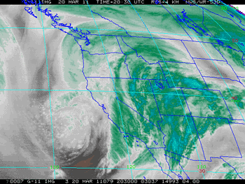
GOES-11 Water Vapor Satellite Image
Sunday, March 20, 2011 at 1:30 p.m.

Running in the rain and wind, and splashing through innumerable puddles, Markos Geneti set a new Los Angeles Marathon record in a time of 2:06:35. It was a remarkable performance, in adverse conditions. From 8:00 a.m. to 12:00 p.m. the Mt. Washington RAWS, near the start of the marathon, recorded 0.59 inches of rain; and the Beverly Hills RAWS near mile 17, recorded 1.27 inches. Periods of heavy rain were reported at Santa Monica Airport, near the finish line, through much of the race. According to a report in the Los Angeles Times sports blog, The Fabulous Forum, thousands of runners were evaluated for hypothermia and 25 runners were hospitalized.

Many rainfall records were set around the area Sunday, with some locations recording as much as one-third of a year's normal rainfall in 24 hours! In the early evening rainfall rates of over an inch an hour were recorded in Woodland Hills and Canoga Park. According to a NWS Storm Report, at 6:14 p.m. a flash flood was reported in Woodland Hills with "mud and debris flowing down the street" and "at least four to five vehicles stuck in flowing water."

Downtown Los Angeles (USC) recorded 2.42 inches of rain yesterday, breaking a record set in 1943. Santa Barbara Airport had its wettest day on record, recording 5.23 inches of rain. Here's an archived copy of the NWS Record Report for March 20, listing some of the rainfall records for the day.

Storm totals in excess of 3 inches have been common in Los Angeles, Ventura, Santa Barbara, and San Luis Obispo counties. Higher totals were recorded in many areas. As of 5:00 p.m. the NWS reported that Van Nuys had recorded 6.74 inches of rainfall, Northridge 6.08 inches, Newhall 7.20 inches, Santa Barbara Airport 6.27 inches, San Marcos Pass 10.72 inches, and Gibraltar Dam 11.73 inches. Here's an archived copy of a NWS report with some rainfall and snowfall amounts from around the area.

Downtown Los Angeles made up its rainfall deficit for the month of March and more, increasing its water year rainfall total to 18.55 inches, or about 123% of normal. This makes the 2010-2011 water year the wettest in Los Angeles during a La Nina over the last 60 years, surpassing the totals recorded during the strong La Ninas of 1955-56 (99% of normal) and 1973-74 (106% of normal), and weak La Ninas of 1967-68 (110%) and 2000-01 (118%).

Sunday's heavy rain appears to have had the earmarks of an atmospheric river event. NRL SSM/I IPW imagery (lower right) shows a pre-frontal band of IPW values of 35-40 kg/m2 impinging the coast, NEDIS blended TPW imagery showed a band of ~25 mm TPW extending some 4000 km to the longitude of Hawaii. A BUFKIT cross section based on 12z NAM data for VNY depicted a low level jet (LLJ) structure coinciding with the period of heaviest rainfall. Research by Dr. F. Martin Ralph, et. al., observed that in atmospheric rivers over the eastern Pacific, 75% of the water vapor transport below 500 mb takes place within the lowest 2.25 km and occurs with LLJ wind structure. In addition in cases where a LLJ is present, there was 50% greater precipitation efficiency.

More information about Southern California weather and climate can be found using our WEATHER LINKS page.

Monday, 21 March 2011 16:09:13 (Pacific Standard Time, UTC-08:00)  #    Disclaimer  |   | 
# Friday, 18 March 2011

Click
HPC 3-Day Precipitation Forecast
For the Period Ending 11:00 a.m. Monday, March 21

Along with January and February, March is one of the big three precipitation months in Southern California in which the average rainfall for Downtown Los Angeles exceeds 3.0 inches. In January we were about 2.5 inches below normal rainfall, and in February about 0.4 inch below normal. So far this March, we're nearly two inches below normal for the month. If it were not for an unusually wet December in which Los Angeles recorded 8.32 inches above normal rainfall, we'd be looking at 50% water year right now instead of over 100%.

If today's 12z NAM and GFS forecasts verify, we could make up that March deficit, and push our water year total up to nearly 120%! According to these numerical forecasts, we could see two to three inches of rain in the Los Angeles area by Monday afternoon, and significantly more in orographically favored foothill and mountain locations. The NAM forecasts moist southerly winds approaching 60 kts at the 5000 ft. level Sunday evening.

BUFKIT analysis of 12z NAM/GFS data generates 2.16/4.11 inches of rain for LAX, 3.56/3.57 inches for Van Nuys, and 4.01/4.20 inches for Santa Barbara. The GFS brings in the second front faster than the NAM, forecasting the onset of heavier rain during the day Sunday, rather than Sunday evening. The 09z SREF puts the probability of more than 1.0 inch of rain in the Los Angeles area for the 24 hour period ending Monday morning at about 90%.

And yes, it does look like there's a chance of rain for the Los Angeles Marathon. Although the heavies rain is forecast to hold off until Sunday afternoon or evening, the 09z SREF pegs the probability of 0.1 inch of rain or more in the Los Angeles area over the 6 hours ending at 11:00 a.m. Sunday at about 70%. BUFKIT analysis of 12z NAM data generates about 0.20 inch at LAX from 8:00 a.m. to noon, with temps in the mid 50's. The GFS says about 0.50 inch over the same period. We'll see!

Be sure to check the NWS Los Angeles/Oxnard web site for the latest forecasts, advisories and warnings. More information about Southern California weather and climate can be found using our WEATHER LINKS page.

Friday, 18 March 2011 11:41:41 (Pacific Standard Time, UTC-08:00)  #    Disclaimer  |   | 
# Thursday, 03 March 2011

Click
BUFKIT Bourgoiun Precipitation Type Analysis
For eWRF Ensembles for VNY at 8:00 am 02/26/11

The wetter ensemble member forecasts prevailed in last Friday's and Saturday's rain and snow event. Downtown Los Angeles recorded 1.20 inches for the storm. This brought the water year total to 15.78 inches, which is about 104% of normal. Although this might seem unusual in a La Nina influenced rain season, during two of the strongest La Ninas in the past 60 years -- 1955-56 and 1973-74 -- Los Angeles recorded 99% and 106% of normal rainfall. Here's an archived copy of a NWS tabulation of some rainfall totals from around the area from early Friday, February 25, to 10:00 p.m. Saturday, February 26.

The NAM and GFS, as well as the SREF and eWRF ensembles, had a tough time forecasting the rainfall produced by our current scenario -- a relatively shallow, moist westerly flow accompanied by modest jet stream dynamics. As this BUFKIT time-height cross section shows, the wettest eWRF ensemble member depicted a 125 kt jet max overhead, suggesting the models had some difficulty in forecasting the structure and strength of the jet. At best, the models forecast a few hundredths of an inch of rain in the Los Angeles area, but the most recent NWS tabulation of rainfall totals for the event lists many stations with between 0.1 and 0.25 inch. As of 4:00 a.m. this morning, Downtown Los Angeles has recorded 0.16 inches for the storm, bumping the water year total to 105% of normal.

As a result of the westerly flow, snow levels are currently high, but one of the interesting facets of last Friday's storm was the possibility of very low elevation snow. A NWS Winter Weather Advisory issued February 25 for the Santa Monica Mountains Recreation Area forecast the snow level to drop overnight from above 3000' to between 1000' and 1500'. Snow accumulations from 1 to 3 inches were expected. Some low elevation post frontal showers of graupel or snow were reported in the east San Fernando Valley and La Crescenta Saturday afternoon, but based on the conditions on Sandstone Peak (el. 3111'), the snow anticipated in the SMMRA did not occur. It was an especially challenging forecast, pitting pre-frontal warm air advection, against post-frontal cold air advection, falling humidity, and fluctuating regions of snow growth and omega.

Developed in part to help forecasters deal with lake effect snow, BUFKIT includes a number of special features for snow forecasting and visualization. For example, following are two time-height cross sections generated by BUFKIT from NAM data for VNY (Van Nuys) from 4:00 p.m. Friday, February 25. The elevation for the Bourgoiun precipitation type analysis for each cross section has been raised to 2711 feet MSL. The first BUFKIT cross section shows snow growth, omega, temperature, and the projected precipitation amount and type. The second cross section shows the same parameters, but with relative humidity instead of omega. The purple and yellow rectilinear contours are snow growth, and the red and blue contours are omega. The green bars are rain amounts, and the blue bars snow. Some of the things to note in these cross sections are the omega/snow growth "cross hair," freezing level, and rapid decrease in humidity with the frontal passage.

What the discrete NAM forecast can't show is the variability of the forecast situation. In its most recent release BUFKIT added support for SREF and eWRF ensembles. When combined with BUFKIT's precipitation type and other tools, ensemble forecasts can provide much additional information and insight. In this case eWRF ensemble members for VNY exhibited widely varying thermal profiles, regions of snow growth, omega, and humidity. BUFKIT's Bourgoiun precipitation type analysis for the eWRF ensemble members at 8:00 a.m. Saturday morning showed freezing levels as high as 2882' and as low as 1176'. The pattern of post-frontal precipitation was also quite variable.

More information concerning Southern California weather can be found using our WEATHER LINKS page.

Thursday, 03 March 2011 08:58:48 (Pacific Standard Time, UTC-08:00)  #    Disclaimer  |   | 
# Monday, 21 February 2011

Click
Experimental HPC 6-Hour Probabilistic Precipitation Guidance
For the 6 Hour Period Ending 4:00 p.m. Tuesday

The rainfall totals from Friday's and Saturday's systems were generally a little below the 2 inches forecast, but it was still enough to boost the water year rainfall total for Downtown Los Angeles to 14.58 inches. This is about 96% of the normal water year total of 15.14 inches. The water year extends from July 1 to June 30, so we still have four months to receive the 0.56 inch of rain that would put us at 100%. Here's an archived copy of a NWS tabulation of some rainfall totals from around the area from early Thursday morning to 10:00 a.m. Sunday.

Southern California's wet weather pattern didn't extend into this week as it looked like it might. The upper low that might have produced the rainfall is now forecast to stay offshore. At the moment it looks like it will mainly result in some clouds as it moves down the coast today through Wednesday. Rain chances increase near the end of the week and into the weekend as an upper low and trough work down the West Coast. Ensemble members vary quite a bit on the track of the upper low, with some solutions wetter in Southern California than others. We'll see!

More information concerning Southern California weather can be found using our WEATHER LINKS page.

Monday, 21 February 2011 14:28:03 (Pacific Standard Time, UTC-08:00)  #    Disclaimer  |   | 
# Thursday, 17 February 2011

Click
HPC 3-Day Precipitation Forecast
For the Period Ending 4:00 a.m. Sunday Morning

The transition from a persistent West Coast ridge to a West Coast trough occurred on Monday more or less as forecast by medium range guidance back on February 5. A series of systems and impulses riding up and over a high amplitude Eastern Pacific ridge are expected to continue to produce cool, blustery weather in Southern California with periods of showers and rain into next week.

Precipitation on Valentine's Day was generally limited to areas north of the Los Angeles basin, but was a little more widespread late Monday night into Tuesday morning, with a number of stations in the Los Angeles area recording a few hundredths of an inch of rain.

Wednesday's system was much more energetic. Because of the convective nature of the precipitation, rainfall amounts were extremely variable, ranging 0.25 inch or less to 1.0 inch or more. Downtown Los Angeles (USC) recorded 0.65 inch of rain for the storm, bringing the water year total for Los Angeles to 13.14 inches. This is well above normal for the date, and about 87% of normal for the water year. Here's an archived copy of a NWS tabulation of some rainfall totals for the period 4:00 p.m. Tuesday to 4:00 a.m. Thursday.

Los Angeles only needs about 2 more inches of rain to top the 100% mark for the water year, and it looks like we could get most of that Friday and Saturday. BUFKIT analysis of 12z NAM data for Van Nuys indicates about 1.6 inches of rain Friday into Saturday, and then another 0.5 inch Saturday night. The HPC 3-day Quantitative Precipitation Forecast for the period ending 4:00 a.m. Sunday also indicates about 2.0 inches of rain in Southern California. This morning's 09z SREF puts the probability of more than 1.0 inch rain for the 24 hour period ending 1:00 p.m. Saturday at about 70%.

Temperature data at the surface and at depth in the equatorial Pacific suggest the La Nina is moderating. The tough question is whether warming will continue into the NH summer, with neutral ENSO conditions prevailing as we move into autumn; or if the ENSO cycle will swing back toward a La Nina state. Since 1949, about half of the first year La Nina episodes continued into a second or third year. At the moment the majority of computer models favor a transition to ENSO neutral or warm conditions by July 2011. Here is a compilation of ENSO Forecasts from the IRI ENSO Quick Look for February 17, 2011. We'll see!

More information concerning Southern California weather can be found using our WEATHER LINKS page.

Thursday, 17 February 2011 13:31:48 (Pacific Standard Time, UTC-08:00)  #    Disclaimer  |   | 
# Saturday, 05 February 2011

Click
NCEP Ensemble Forecast
240 hr. Forecast for February 14 at 4:00 p.m. PST

Although the Pacific jet did expand as anticipated through about January 27, and then retract around January 29, leading to a upper low off the California coast, it wasn't the discontinuous ridge regression which had been hoped for -- or the change in pattern that would open the door to Pacific storms wishing to visit sunny Southern California.

The area did manage to get a bit of rainfall out of the system. Downtown Los Angeles (USC) recorded 0.21 inch on Sunday, bringing the rainfall total for January up to a paltry 0.79 inches, which is more than 2.5 inches below normal for the month. At this point Downtown Los Angeles remains almost 5 inches above normal for the water year (July 1 to June 30), but with each dry day that cushion grows a little smaller. Here's an archived copy of a NWS tabulation of some rainfall totals from last Sunday's storm.

Well, what the MJO couldn't do maybe random influences will. Both the GFS and ECMWF are forecasting a change to a wetter pattern for California around Valentine's Day. This is supported by the NCEP Ensembles, and ESRL/PSD Analog Probabilistic Precipitation Forecasts for the 8-14 day period. As this CPC 8-14 day Precipitation Outlook indicates, the chances look the best from Central California, north into Oregon. We'll see!

More information concerning Southern California weather can be found using our WEATHER LINKS page.

Saturday, 05 February 2011 16:48:56 (Pacific Standard Time, UTC-08:00)  #    Disclaimer  |   | 
# Thursday, 20 January 2011

Click
Extended Pacific Jet and Resulting Mega-Ridge
GFS Forecast for Sunday Afternoon

Over the next two weeks, the MJO signal currently propagating across the western Pacific is forecast to destructively interfere with the La Nina base state, suppressing convection in the Indian Ocean and Indonesia and enhancing convection near the dateline. This is forecast to result in a transition from upper tropospheric anomalous cyclones to anticyclones near the dateline, and an extension of the East Asian/Pacific jet. These circulation changes may eventually lead to a retrogression of our persistent West Coast ridge, or perhaps a breakthrough of the westerlies underneath the highly amplified ridge.

The key word here is eventually. Over the next week or so, the extending Pacific jet is forecast to reamplify the ridge over the West Coast. But at some point, perhaps near the beginning of February, destructive interference in the Western Pacific will dwindle and convection in the Indian Ocean will strengthen. This should result in retraction of the Pacific jet, and possibly, a West Coast trough. The 240 hr forecast of the 12z ECMWF hinted at this possibility, as did the 18z GFS. We'll see!

After starting out cold and wet, the weather this January in Southern California, and much of the state, has been warm and dry. Monday, Pierce College in Woodland Hills hit a high of 88°F, and Downtown Los Angeles (USC) 84°F. So far this January, only 0.58 of rain has been recorded at Downtown Los Angeles (USC), which is a little less than one-third of normal for the month. However, because of our prodigious December rainfall the water year total at Los Angeles is currently 6.5 inches above the normal for the date of 5.78 inches.

Earlier this month I photographed these mid-level mammatus clouds over the western San Fernando Valley. They were produced by the moisture and dynamics associated with a closed upper level low that was about 390 miles WSW of Los Angeles. To see how the clouds evolved and more about the scenario at the time, see this post on PhotographyontheRun.com.

More information concerning Southern California weather can be found using our WEATHER LINKS page.

Thursday, 20 January 2011 19:25:42 (Pacific Standard Time, UTC-08:00)  #    Disclaimer  |   | 
# Sunday, 09 January 2011

Following is a chart comparing the 2010-11 La Nina to 22 other cold ENSO episodes that have occurred since 1949. With the exception of 1961-62 and 2008-09, the cold episodes are based on the Oceanic Niño Index (ONI) and are those specified in the CPC's tabulation of Cold & Warm Episodes by Season. A description of the parameters follows the chart. A GWO phase space plot is included for those cold episodes for which AAM data is available.

Year Nov-Mar
AAM
Peak MEI4 Peak MEI Season Peak
ONI
Peak ONI Season L.A. Rain GWO
Phase Plot
1949-501,2 -- -1.423 APRMAY -1.7 DJF 9.94 --
1950-511 -- -1.261 NOVDEC -1.0 NDJ, DJF 8.21 --
1954-551 -- -1.578 MAYJUN (54) -1.2 ASO 11.94 --
1955-561 -- -2.276 MAYJUN (55) -2.0 OND 16.00 --
1956-571 -- -1.516 MAYJUN (56) -0.9 SON, OND 9.54 --
1961-623 -0.511 -1.081 DECJAN -0.6 ASO, SON 18.79 Click for Nov-Mar GWO Phase Space Plot
1962-63 -1.254 -0.849 JANFEB -0.7 OND, NDJ 8.38 Click for Nov-Mar GWO Phase Space Plot
1964-65 -1.141 -1.496 JULAUG -1.2 SON, OND 13.69 Click for Nov-Mar GWO Phase Space Plot
1967-68 -0.767 -1.060 APRMAY -0.9 JFM 16.58 Click for Nov-Mar GWO Phase Space Plot
1970-71 -0.973 -1.898 MARAPR -1.3 DJF, JFM 12.32 Click for Nov-Mar GWO Phase Space Plot
1971-72 -0.172 -1.463 AUGSEP -1.0 OND 7.17 Click for Nov-Mar GWO Phase Space Plot
1973-74 -1.326 -1.937 DECJAN -2.1 NDJ 14.92 Click for Nov-Mar GWO Phase Space Plot
1974-75 -0.839 -1.256 OCTNOV -0.9 OND 14.35 Click for Nov-Mar GWO Phase Space Plot
1975-76 -0.711 -2.000 SEPOCT -1.7 OND, NDJ 7.22 Click for Nov-Mar GWO Phase Space Plot
1984-85 -0.595 -0.743 APRMAY -1.1 NDJ 12.82 Click for Nov-Mar GWO Phase Space Plot
1988-89 -1.135 -1.591 AUGSEP -1.9 OND, NDJ 8.08 Click for Nov-Mar GWO Phase Space Plot
1995-96 -0.226 -0.641 DECJAN -0.7 OND to JFM 12.46 Click for Nov-Mar GWO Phase Space Plot
1998-99 -0.539 -1.219 JANFEB -1.4 NDJ, DJF 9.09 Click for Nov-Mar GWO Phase Space Plot
1999-00 -0.778 -1.228 JANFEB -1.6 NDJ, DJF 11.57 Click for Nov-Mar GWO Phase Space Plot
2000-01 -0.795 -.747 OCTNOV -0.7 NDJ 17.94 Click for Nov-Mar GWO Phase Space Plot
2007-08 -1.007 -1.619 FEBMAR -1.4 DJF, JFM 13.53 Click for Nov-Mar GWO Phase Space Plot
2008-093 -0.594 -.783 SEPOCT -0.8 DJF 9.08 Click for Nov-Mar GWO Phase Space Plot
2010-11 -0.595 -2.037 AUGSEP -1.4 SON, OND, NDJ 20.20 Click for Nov-Mar GWO Phase Space Plot
1. AAM and AAM tendency anomaly data not available.
2. Based on ONI values beginning with DJF 1949-50.
3. ONI did not meet threshold of 5 consecutive overlapping seasons.
4. MEI values are normalized and may change as new data is added. Specified values were current as of November 8, 2011.

Nov-Mar AAM: The mean of the global relative atmospheric angular momentum anomaly for the period November 1 to March 31 of the following year. Data is from the GWO phase space data file linked on the Global Synoptic Dynamic Model page of the PSD Map Room Climate Products. Reference Weickmann and Berry, 2008.

Peak MEI: The peak seasonal value of the Multivariate ENSO Index (MEI). Reference Wolter and Timlin, 1993, 1998. MEI values are normalized and may change as new data is added.

Peak MEI Season: The peak bi-monthly season(s) for which the MEI is computed.

Peak ONI: The peak Oceanic Niño Index (ONI) based on SST anomalies in the Niño 3.4 region. Reference Climate Prediction Center Cold & Warm Episodes by Season.

Peak ONI Season: The peak tri-monthly season(s) for which the ONI is computed.

L.A. Rain: The water year precipitation total in inches for Downtown Los Angeles (USC). Reference NWS Los Angeles/Oxnard Downtown Los Angeles Climate Page, 1921-2006 Calendar Year Rainfall.

GWO Phase Space Plot: Plot of global relative atmospheric angular momentum anomaly vs. global relative atmospheric angular momentum tendency anomaly for the period November 1 to March 31 of the following year. Data is from the GWO phase space data file linked on the Global Synoptic Dynamic Model page of the PSD Map Room Climate Products. Reference Weickmann and Berry, 2008.

Sunday, 09 January 2011 15:02:14 (Pacific Standard Time, UTC-08:00)  #    Disclaimer  |   |