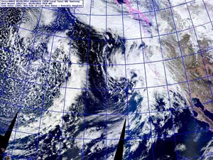

NRL Terra-MODIS Composite 02/26/2014 2150 GMT
02/26-02/27 System Approaching Coast; 02/28-03/02 System West of 140W.
Extended by the active phase of the MJO, a strong Pacific jet provided the impetus for two Pacific storm systems to undercut a persistent ridge over the West Coast and bring much-needed rain to parched California.
Beginning Wednesday evening (Feb 26) and continuing into Sunday (Mar 2), the storm systems produced the most rain over five days in Los Angeles since December 2010, ending a nearly 14 month period with record-setting dry weather. Los Angeles experienced the driest calendar year on record in 2013, and until Friday had recorded less water year rainfall than in 2006-07 — the driest water year (July 1 - June 30) since recordkeeping began in 1877.
According to preliminary precipitation data, Downtown Los Angeles (USC) recorded 4.52 inches of rain over the course of the storms, increasing its water year total from a dessicated 11% of normal to a not-too-bad-considering 50% of normal. Downtown Los Angeles' water year rain total now stands at 5.72 inches. This exceeds last year's cumulative precipitation total on this date by more than an inch, but still leaves us with a deficit of nearly six inches. The storms increased February's rainfall total to near normal, and jump-started March with nearly half its normal amount of rain. Prior to these storms the most rain recorded at Los Angeles in a day this water year was 0.29 inch back in November!
Orographically favored foothill and mountain areas that faced into the storms' moist southerly flow recorded some impressive rainfall totals. According to this compilation of preliminary rainfall totals from the NWS Los Angeles/Oxnard, Opids Camp near Mt. Wilson recorded nearly 11 inches of rain, and several stations in the Ventura Mountains recorded double-digit rainfall totals. Here are a CNRFC map of Gridded QPE for the 7-day period ending March 3 at 4:00 am and a CNRFC map of 7-day Gridded QPE and 120 hr raw precipitation for stations recording over 4.0 inches.
With this recent rainfall 2013-14 will not be the driest water year in Los Angeles, but one good storm, or even two, "does not a rain season make." In the short term these storms have dramatically reduced the fire danger, provided crucial relief to plants and animals, and increased groundwater and reservoir storage. What happens in the longer term we'll just have to see. Over the next several days a series of systems are forecast to produce additional rain from Central California north into the PNW. While no rain is forecast in Southern California over the next week or so, and the 8-14 day outlook is for below average precipitation, as long as the Pacific weather pattern remains progressive there should be additional opportunities for rain in the weeks ahead.
It looks like El Nino is beginning to knock more loudly at the door. The third and strongest of a series of oceanic downwelling Kelvin waves continues to significantly increase subsurface equatorial heat content in the Pacific basin and another strong Westerly Wind Burst has occurred in the equatorial Pacific. The CFSv2 forecasts Nino 3.4 anomalies to reach El Nino thresholds in the May-June 2014 timeframe, however the IRI/CPC Plume-based and Consensus Forecasts released February 20 are less bullish, forecasting about a 40% chance of El Nino conditions developing in the MJJ season. We'll see!
More information about Southern California weather and climate can be found using our WEATHER LINKS page.