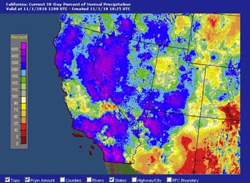

AHPS Precipitation (Percent of Normal)
For 30 Days Ending November 1, 2010.
October was an unusually wet month in coastal Southern California. Many areas recorded more than an inch above normal rainfall, and some as much as 3 inches above normal. In a month where around 0.5 inch is considered normal, some areas received several times the normal amount of rainfall.
Most of October's rain resulted from two energetic upper lows, and a relatively strong trough/front that swept through the area October 30th. The front produced a new precipitation record for the date of 1.09 inches at Santa Barbara Airport Here's an archived NWS Public Information Statement with some rainfall totals for that storm.
Last week, an approaching Pacific trough pumped up a thick high pressure ridge over California, sending temperatures soaring and breaking temperature records across the area. November 3rd Long Beach Airport set a new high temperature record for the date of 100°F, and Downtown Los Angeles set a new record of 97°F. November 4th temps were once again in high 90s and several stations broke or tied high temperature records. Here are archived copies of the NWS Record Event reports for November 3 and November 4.
The southern part of the Pacific trough that produced our record high temps cut-off into a small upper low as it approached the coast, and moved onshore north of the Los Angeles basin on Saturday. The remainder of the trough and its associated front moved through the area Sunday evening into Monday. The front held together a little better than expected, and rainfall totals in the Los Angeles basin and valleys generally ranged from about 0.10 inch to 0.30 inch. Here's an archived NWS Public Information Statement with some rainfall totals from around the area..
The latest round of rainfall leaves many areas of Southern California way ahead on rainfall totals for the water year. Downtown Los Angeles (USC) missed out on a couple of the systems, and as of close of business yesterday has recorded 1.10 inch for the water year, which is only 0.06 inch above normal. By comparison, Los Angeles Airport is 0.85 inch above normal, and Camarillo/Oxnard is 0.97 inch above normal. This headstart on the rain season should help keep our rainfall totals a little closer to normal as our La Nina influenced rain season continues.
Speaking of La Nina, the September/October value of the Multivariate ENSO Index (MEI) increased slightly by 0.079 sigma, ending the record plunge from El Nino conditions earlier this year. In the past 30 days there was some decrease in the magnitude of negative SST anomalies in the east-central equatorial Pacific, but subsurface temperatures remain quite cool. Computer models are split on whether Nino 3.4 SST anomalies will continue to decline in magnitude during the Northern Hemisphere winter, but nearly all models indicate decreasing anomalies in early 2011. We'll see!
More information concerning Southern California weather can be found using our WEATHER LINKS page.