# Thursday, February 25, 2010

GOES-11 Water Vapor Image (UW-MAD) February 25, 2010 - 7:00 a.m. PST Click
GOES-11 Water Vapor Image (UW-MAD)
February 25, 2010 - 7:00 a.m. PST

A weakening frontal band produced some light rain in Southern California yesterday afternoon and evening. Precipitation amounts in the Los Angeles area ranged from a trace to a few hundredths of an inch. Amounts were higher to the north, closer to the surface low. A few stations in Santa Barbara and San Luis Obispo counties recorded more than 0.5 inch and some recorded more than an inch. Here is an archived copy of a NWS Public Information Statement with some precipitation totals from around the area.

Today, a much stronger Pacific storm system begins to impact the West Coast, with the highest precipitation totals forecast for Northern California and the Sierra Nevada. BUFKIT analysis of this morning's 12z NAM data for Van Nuys generates about 1.3 inch of rain, beginning late Friday night and continuing into Saturday afternoon. The 18z NAM run starts the rain a little earlier Friday night, and extends the period of precipitation into Saturday evening. It produces about 1.8 inch of rain at Van Nuys over the period. Today's 09z SREF indicated a probability of about 50%-70% that precipitation in the Los Angeles area would exceed 0.5 inch for the 24 hr. period ending Saturday afternoon at 4:00 p.m. Precipitable water values approaching an inch and strong southerly low level inflow could produce higher rain rates and precipitation totals on south to southwest facing foothill and mountain slopes.

Since being reinforced by a strong MJO at the end of January, El Niño convection has remained active in the Central Pacific (animation). In terms of relative atmospheric angular momentum (AAM), the atmosphere's response is the strongest since the El Ninos of 1997-1998 and 2004-2005. Average AAM for our rain season (November to date) has increased from -0.046 at the beginning of the year to 0.341 as of February 23. This El Nino Comparison Chart shows how this El Niño compares to others since 1950.

So far this rain season, Downtown Los Angeles (USC) has recorded above average rainfall every month, except for November. And November's rain came early -- in October.

More information concerning Southern California weather can be found using our WEATHER LINKS page.


Thursday, February 25, 2010 8:26:22 AM (Pacific Standard Time, UTC-08:00)  #    Disclaimer  |   | 
# Saturday, February 20, 2010

Click
Yesterday's Weak Pacific System Moving Onshore
NRL NexSat Day/Night 02/19/10 4:00 p.m.

Last night's weak Pacific system had its moments, and managed to produce precipitation amounts ranging from about 0.1 inch to 0.25 inch in the Los Angeles area. Here is a NWS Public Information Statement with some precipitation totals. Downtown Los Angeles (USC) recorded 0.14 inches for the storm, increasing the water year total to 13.34 inches. The is 3.58 inches above normal for the date.

A moisture-starved trough on the downstream side of a pinched upper level ridge over the West Coast is forecast to dig southward and could produce some additional precipitation tomorrow. Today's 09z SREF indicated a probability of about 30%-50% that precipitation in the Los Angeles area would exceed 0.1 inch for the 24 hr. period ending Monday morning at 4:00 a.m. The forecast probability that it would exceed 0.25 inch over the same period is about 10%-30%.

More information concerning Southern California weather can be found using our WEATHER LINKS page.


Saturday, February 20, 2010 4:13:13 PM (Pacific Standard Time, UTC-08:00)  #    Disclaimer  |   | 
# Wednesday, February 10, 2010

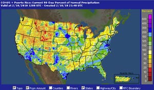
AHPS 90 Day Precipitation (Percent of Normal) as of February 10, 2010 4:00 a.m. PST Click
AHPS 90 Day Precipitation (Percent of Normal)
February 10, 2010
4:00 a.m. PST

Yesterday's cold upper level low behaved about as expected, following a track just off the coast. Because of the convective nature of the system, rainfall amounts varied from under 0.25 inch to over 1.0 inch in some foothill and mountain locations. About a foot of snow was reported at the mountain resorts. Here is a NWS Public Information Statement with precipitation totals from around the area. Downtown Los Angeles (USC) recorded 0.44 inches for the storm, increasing the water year total to 13.2 inches. The is 4.78 inches above normal for the date.

Compared to the AHPS 90 Day Precipitation map from about 40 days ago, a fairly typical El Niño precipitation pattern has emerged in the West. Medium range models are projecting about a 7-10 day break in what has turned out to be a busy rainy season in Southern California. Assuming these forecasts verify, such a break could not come a better time for those threatened by mudslides and debris flows. The recent enhancement of El Niño convection by the MJO, and the ongoing phase 6-7-8 transition of the GWO might have resulted in a wetter pattern, and this has occurred in similar circumstances in past El Ninos.

More information concerning Southern California weather can be found using our WEATHER LINKS page.


Wednesday, February 10, 2010 3:34:58 PM (Pacific Standard Time, UTC-08:00)  #    Disclaimer  |   | 
# Saturday, February 6, 2010

UCAR NEXRAD Regional Composite Image February 6, 2010 - 4:45 a.m. PST Click
UCAR NEXRAD Regional Composite Image
February 6, 2010 - 4:45 a.m. PST

Wet antecedent conditions and heavy rain early this morning combined to amplify the amount of runoff from our latest Winter storm. In addition to localized street flooding, mud and debris flows have occurred in the vicinity of the Station Fire burn area. The trough associated with the system, and a second frontal band are moving onshore this afternoon, and are producing some additional rainfall in the Los Angeles area. Please refer to www.weather.gov/losangeles for the latest warnings and weather information.

Yesterday's runs of the NAM/WRF did a pretty good job of forecasting the area of enhanced precipitation that developed overnight in Southern California. BUFKIT analysis of 12z NAM data from yesterday generated about 2.4 inches of precipitation at KLAX for the 24 hr. period ending early this morning. According to preliminary NWS data, as of 10:00 a.m. LAX had recorded 2.31 inches for the storm, and Downtown Los Angeles (USC) had recorded 2.84 inches. The water year total rainfall for Los Angeles is now about 5 inches above normal. Here is a NWS Public Information Statement with rainfall totals from around the area. (Link will be updated as revised totals become available.)

The recent enhancement of El Nino convection in the equatorial Pacific by the Madden-Julian Oscillation (MJO) has triggered a strong atmospheric response. A Global Wind Oscillation (GWO) phase space plot shows large increases in relative atmospheric angular momentum (AAM) and AAM tendency. As a result of this increase, the average relative AAM anomaly for the rain season to date is now positive. As mentioned in this post from December 2009, relative AAM is correlated with rain season precipitation in Southern California. This suggests an increased likelihood of wet weather in Southern California in the medium range outlook period.

So what happens next? The ECMWF and GFS projections have not been particularly consistent. At the moment, it looks like a shortwave trough could affect Southern California in the Tuesday evening or Wednesday timeframe and then again Friday. We'll see how the week develops.

More information concerning Southern California weather can be found using our WEATHER LINKS page.


Saturday, February 6, 2010 3:09:12 PM (Pacific Standard Time, UTC-08:00)  #    Disclaimer  |   |