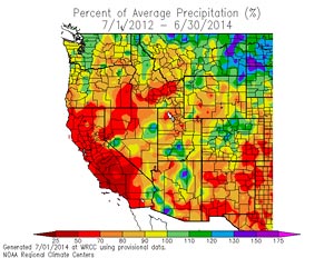

Two-Year Percentage of Normal Precipitation
July 1, 2012 to June 30, 2014 (WRCC).
Downtown Los Angeles (USC) finished the water year (July 1 to June 30) with 6.08 inches of recorded rainfall. This is about 41% of the 1981-2010 normal of 14.93 inches. It was the seventh driest water year since recordkeeping began in 1877. When combined with last year's water year total of 5.85 inches, the back-to-back water years from July 1, 2012 to June 30, 2014 are the driest on record for Los Angeles. The total rainfall deficit over the two year period was about 18 inches.
El Nino has been knocking on the door, but until very recently the atmosphere has only been responding in spits and sputters.
The weekly OISST.v2 Nino 3.4 SST temperature anomaly has been vacillating in the range 0.4 to 0.6 beginning with the week centered on April 23, 2014 and now stands at 0.5. Nino 1+2 and Nino 3 anomalies have generally been increasing and as of the week centered on June 25 are at 1.6 and 1.0 respectively. Here is a plot of the Nino regions SST anomalies from the CPC. Following a period of strengthened tradewinds, another westerly wind burst has developed in the Western Pacific. There have been several WWB this year and the most recent WWB could lead to additional warming of equatorial SSTs.
In response to the upwelling phase of an oceanic Kelvin wave there has been a decrease in subsurface Pacific equatorial heat content and some associated cooling at depth.
The Global Wind Oscillation (GWO) can be a useful tool for evaluating the degree to which the atmosphere is responding to El Nino or La Nina conditions. As this plot of the GWO for the period March 1 to July 31, 1997 shows, during the spring and summer of 1997 El Nino conditions were already resulting in a definitive atmospheric response. Here is a plot of the GWO from March 1 to July 1 of this year. Over most of this period the GWO has shown a neutral or weak La Nina-like response. Recently the GWO has exhibited a positive shift in AAM anomaly that, if sustained, could be indicative of a coupled ocean-atmosphere response.
The Plume-based and Consensus Forecasts in the June 19 IRI/CPC ENSO Quick Look (PDF) show an increasing chance of El Nino conditions developing over the NH summer, with an approximately 80% chance of El Nino conditions being established by the OND season. A July 2 run of the CFSv2 forecasts Nino 3.4 anomalies to briefly decline, then increase substantially from July into October. We'll see!
More information about Southern California weather and climate can be found using our WEATHER LINKS page.