Page 1 of 1 in the SierraSnowpack category
# Tuesday, 24 January 2017

California Percent of Normal Precipitation for July 1 to January 22, 2017 (WRCC) Click
California Percent of Normal Precipitation (WRCC)
July 1, 2016 to January 22, 2017

Update on February 2, 2017. Downtown Los Angeles has ended January 2017 with 8.38 inches of rain. This is 269% of the normal January rainfall total of 3.12 inches. The preliminary Rain Year precipitation total for Downtown Los Angeles for July 1 through January 31, 2017 is 14.33 inches, which is 193% of the normal amount of 7.44 inches. Here is an updated California Percent of Normal Precipitation map from the Western Regional Climate Center for July 1, 2016 to January 31, 2017.

On the heels of a wet December, a series of Pacific storms have resulted in the wettest start to the Rain Year (July 1 - June 30) and Water Year (October 1 to September 30) since the very wet year of 2004-2005.

The six day period from January 18-23 was particularly wet, with three storms producing a total of 5.53 inches of rain at Downtown Los Angeles (USC). Here are some preliminary 7-day precipitation totals from around the area from the Ventura County Watershed Protection District.

The last system of the series, which brought very heavy precipitation to the area on Sunday, was associated with a well-defined atmospheric river. Precipitation totals in the Los Angeles area for the storm generally ranged from about 2 to 5 inches. According to the NWS, new rainfall records for January 23 were set at Los Angeles Airport (2.94 inches), Camarillo (2.74 inches) and Long Beach Airport (3.97 inches). The rainfall at Long Beach Airport was the most ever recorded in a day at that location. Here are some precipitation totals from around the area compiled by the NWS Los Angeles/Oxnard and NWS San Diego.

As of yesterday Downtown Los Angeles (USC) has recorded 14.33 inches of rain for the Rain Year. This is 217% of the normal amount of 6.65 inches for the date, and 97% of the normal amount of rainfall for an entire year. Assuming we don't get any more rain this January, the 8.38 inches recorded will work out to 269% of the normal amount for the month.

The California Cooperative Snow Surveys Snow Water Equivalents report for today puts the snowpack for the date at an average 197% of normal. That's two times the normal amount.

A little precipitation has crept back into the GFS, GEFS and ECMWF forecasts for the Los Angeles area the first week of February. We'll see!

More information about Southern California weather and climate can be found using our WEATHER LINKS page.

Tuesday, 24 January 2017 19:10:12 (Pacific Standard Time, UTC-08:00)  #    Disclaimer  |   | 
# Tuesday, 20 January 2015

Southwestern U.S. Current Departure from Normal Precipitation Since October 1 as of 1/19/2015 12:00 UTC. Click
Current Departure from Normal Precipitation Since October 1
AHPS Precpitation Analysis as of 1/19/2015 12:00 UTC.

After being negative for 3 1/2 years, the PDO Index has been positive since January 2014. December's PDO value of 2.51 is the highest for that month on record (since 1900), exceeding December 2002's value of 2.10 and December 1940's value of 1.96.

Even so, the highly anticipated 2014-15 El Nino continues to dawdle with little ocean-atmosphere coupling and an emphasis on an higher amplitude meridional flows. Due in part to the upwelling phase of a series of oceanic Kelvin waves, equatorial Pacific heat content and SST anomalies have diminished. After having been at or above 0.5 °C for the past twelve weeks OISST.v2 Nino 3.4 SST Anomalies dropped to 0.4 °C for the week centered on January 7, 2015 and as of the week of January 14 was at 0.5 °C.

The Multivariate ENSO Index (MEI) for NOV/DEC has decreased 0.13 SD to +0.58, but has maintained its historic rank (since 1950) at 47. A rank of 46 is the threshold for weak El Nino conditions in the context of the MEI. The FNL Global Wind Oscillation for the past 90 days continues to reflect the lack of definitive atmospheric coupling.

So far this rain season Northern California and the coastal areas of Central and Southern California have fared much better in terms of precipitation than last year. As of today Downtown Los Angeles (USC) precipitation for the water year (beginning July 1) is at 90% of normal and Downtown San Francisco is at 127%.

As this AHPS plot of precipitation since October 1 shows, many areas of California have recorded at least 75% of normal precipitation. Unfortunately the Sierra Nevada is not one of them. While better than last year's dismal 14% of normal on this date, this year's snowpack is currently well below average, and was last reported at 36%. Here is an AHPS plot of precipitation departure since October 1 that shows the deficits in the Sierra Nevada.

At the moment it doesn't look like the snowpack will get much help in the short term. After fending off a little shortwave the blocking ridge is forecast to rebuild to new heights, bringing unseasonably mild weather to much of the West Coast. There does appear to be the possibility of a wildcard low latitude low developing under the block and that could result in some precipitation in Southern California next week. If such a system develops, given the warm state of the Eastern Pacific, it could be wetter than expected. We'll see!

In the early morning hours of Friday, December 12, 2014, a very strong cold front, enhanced with moisture from an atmospheric river, produced a line of strong storms that produced rain rates in the Springs Fire burn area as high as 2 inches per hour. This resulted in widespread flash floods and debris flows in the burn area, much of which is in Pt. Mugu State Park. Mud and debris flows originating from the burn area inundated homes below Conejo Mountain and closed Pacific Coast Highway. This slideshow includes photos of the aftermath of the flash floods and debris flows in Blue Canyon, Sycamore Canyon and Upper Sycamore. The photos were taken on a trail run on December 14, 2014. Also included are some NWS Los Angeles/Oxnard tweets and some additional meteorological images and info.

More information about Southern California weather and climate can be found using our WEATHER LINKS page.


Tuesday, 20 January 2015 08:44:31 (Pacific Standard Time, UTC-08:00)  #    Disclaimer  |   | 
# Sunday, 20 October 2013

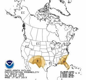
CPC Dec-Jan-Feb Precipitation Outlook Click
CPC Dec-Jan-Feb Precipitation Outlook
Released October 17, 2013.

Updated November 5, 2013. My mistake -- a spreadsheet range error -- thanks for the heads up Reg! The driest January 1 to November 1 for Downtown Los Angeles was in 1972 with 0.92 inch. Here are the driest ten years for that period:

1. 1972 0.92
2. 2002 1.62
3. 1984 1.93
4. 1961 2.37
5. 1971 2.39
6. 1947 2.45
7. 2013 2.78
8. 1894 2.89
9. 1953 2.89
10. 2007 3.37

An energetic upper level low brought the first widespread precipitation of the rain season to Southern California October 9, with rain at the lower elevations and some snow in the local mountains. Rainfall amounts varied widely, ranging from a trace in some areas to over an inch in the mountains.

Downtown Los Angeles (USC) recorded only 0.04 inch for the storm, bringing the water year rainfall total to 0.13 inch, which is 0.31 inch below normal. Downtown Los Angeles has recorded only 2.76 inches of rain since January 1. This is one of the driest January 1 - October 20 in Los Angeles over the past 135 years! To get out of the bottom ten for calendar year rainfall Los Angeles needs about 3.5 inches of rain by December 31. Normal rainfall for November is 1.04 inches and for December is 2.33 inches.

For months I've been monitoring climate data and forecasts looking for something on which to base a 2013-14 Winter precipitation Outlook. Historically ENSO has played the major role in Southern California rain season weather, with El Nino conditions generally producing wetter weather and La Nina conditions generally drier. But ENSO conditions are currently Neutral and are expected to remain so through the end of the year.

Most climate models forecast slow warming of SSTs in the equatorial Pacific (NINO 3.4 region) over the next several months, but at this time of the year it would be very unusual to have substantial warming. The CPC/IRI ENSO Forecasts from IRI's October Quick Look indicate the probability of an El Nino developing before the end of the year is less than 20% -- and 20% seems high.

One computer model that at times has been forecasting above average precipitation in Southern California this Winter is the Climate Forecast System version 2 (CFSv2). The CFSv2 is fully coupled ocean-atmosphere-land-sea ice model used to forecast parameters such as sea surface temperature, temperature and precipitation rate. While skillful at predicting tropical SSTs, the CFSv2 generally performs very poorly when forecasting precipitation over land, so forecasts such as this earlier one for Dec-Jan-Feb must be viewed somewhat skeptically.

Another glass half-full observation is that the Madden-Julian Oscillation (MJO) has been relatively active this year and if this activity continues it provides recurring opportunities for enhanced U.S. West Coast precipitation. The downside is that it can result in periods of dry weather as well.

With the ocean and atmosphere neutral there's just not much on which to base a rain season forecast. As a result of the government shutdown the release of the official NOAA 2013-14 Winter Outlook has been delayed until November. The October CPC outlook is usually the basis of the initial official NOAA U.S. Winter Outlook. The U.S. Dec-Jan-Feb Precipitation Outlook, released October 17, calls for an equal chance of below average, average, or above average precipitation for all of California. We'll see!

More information about Southern California weather and climate can be found using our WEATHER LINKS page.

Sunday, 20 October 2013 15:31:26 (Pacific Daylight Time, UTC-07:00)  #    Disclaimer  |   | 
# Thursday, 23 December 2010

AHPS Precipitation (Percent of Normal) For 90 Days Ending December 23, 2010 at 4:00 a.m Click
AHPS Precipitation (Percent of Normal)
For 90 Days Ending December 23, 2010 at 4:00 a.m.

After producing phenomenal rainfall totals in Southern California and snowfall totals in the higher elevations of the Sierra, the Pacific low and trough responsible for days and days of wet weather has finally moved east.

Some stations recorded more rain in the last 7 days that would normally be recorded over an entire year. Precipitation amounts over 10 inches were common, and several stations recorded over 20 inches. Tanbark, in the San Gabriel Mountains recorded 24.7 inches, NF Matilija in the Ventura Mountains recorded 24.09 inches, and Lytle Creek in the San Bernardino Mountains recorded an astonishing 26.35 inches!

Here's are snapshots of provisional 7-day rainfall totals in Ventura County and 7-day rainfall totals in Los Angeles County from the Ventura County Watershed Protection District ALERT Map Viewer; and a snapshot of provisional 7-day rainfall totals from the NWS San Diego's Experimental Rainfall Summary Display. And here are archived copies of NWS precipitation summaries with preliminary rainfall totals from the NWS Los Angeles/Oxnard and NWS San Diego offices.

The remarkable amount of rainfall makes December 2010 one of the wettest on record in Southern California. According to preliminary NWS data Downtown Los Angeles (USC) has recorded 8.52 inches of rain so far this December. This ranks it as the third wettest December in Los Angeles since recordkeeping began in 1877, exceeded only by December 1889 (15.8 inches) and December 2004 (8.77 inches). With additional rain a possibility, December 2010 only needs 0.25 inch to surpass 2004. For more detailed info see "A Look at the Record-Breaking Week of Rainfall" a PDF from the NWS Los Angeles/Oxnard.

The Sierra recorded gargantuan snowfall totals, with some of the largest being in the Southern Sierra. In the last week the snow sensor at Farewell Gap recorded 22.6 inches snow water equivalent, which roughly translates to 18 feet of snow. This morning California Cooperative Snow Surveys reports the Southern Section Sierra snowpack at 287% of normal, and the snowpack overall in the Sierra at 207%! Mammoth Mountain reports 167 inches of snow so far this December, a new record for the period 1968 to date, obliterating the records set in 1971 (139.8 inches) and 2002 (134.4 inches).

As of yesterday Downtown Los Angeles (USC) rainfall was a whopping 6.88 inches above normal for the water year. That puts us way, way ahead of what is typical for a La Nina influenced rain season -- at least for a couple of months.

Update December 24, 2010. Looks like there will be two opportunities before the end of December for Downtown Los Angeles (USC) to increase its rainfall total for the month and become the second wettest December since recordkeeping began in 1877. The first chance is Saturday night. For the 24 hour period ending 10:00 a.m. Sunday, the 09z SREF puts the probability of more than 0.25 inch of precipitation in the Los Angeles area at about 70%. The WRF ensembles precipitation forecast for LAX for Saturday night ranges from a low of about 0.25 inch to a high of about 0.7 inch. The 18z GFS says the second opportunity will be Wednesday, and forecasts a little under an inch of rain at LAX. We'll see!

More information concerning Southern California weather can be found using our WEATHER LINKS page.

Thursday, 23 December 2010 12:30:24 (Pacific Standard Time, UTC-08:00)  #    Disclaimer  |   | 
# Friday, 17 December 2010

HPC 5-Day Precipitation Forecast For the 5 Day Period Ending December 22, 2010 at 4:00 a.m. Click
HPC 5-Day Precipitation Forecast
For the 5 Day Period Ending December 22, 2010 at 4:00 a.m.

If current precipitation forecasts and outlooks validate, December 2010 could become one of the wettest on record in California, and at the higher elevations of the Sierra, one of the most snowy. This morning's 5-day precipitation forecast from the Hydrometeorological Prediction Center, for the 5-day period ending early Wednesday morning, indicates up to 7.9 inches of precipitation locally, and 14.7 inches (water equivalent) in the Sierra. And additional precipitation is forecast beyond the 5 day period.

A large Pacific low working in concert with a low west of Hawaii has established a tropical connection, and is pumping copious amounts of moisture into California. This tropical moisture conveyor belt scenario is currently forecast to continue into next week. Late Sunday, shortwave impulses dig down into the low and elongate it southwestward, creating a large longwave trough. This northern part of this trough is forecast to evolve into another large upper and surface low in the northeastern Pacific. The southern part of the trough is forecast to develop a surface low and front that moves into Southern California Tuesday into Wednesday.

In the short term, BUFKIT analysis of WRF ensemble data for Van Nuys shows precipitation totals through early Sunday morning ranging from about 1.0 inch up to about 3.5 inches. Analysis of 12z NAM data for Van Nuys produces around 1.8 inches through early Sunday morning and nearly 5 inches through early Monday morning. The 09z SREF pegs the probability of more than 1.0 inch of precipitation in Los Angeles area at around 70%. Precipitable water values of over 1.0 inch, high relative humidity, and a strong south to southwesterly inflow of over 30 knots should produce significantly enhanced precipitation on favored slopes -- generally those with a south to southwest aspect.

It's a little early to put much credence in forecasts for next week, other than more rain appears likely. The 06z GFS produced astronomic precipitation totals mid-week -- several inches more than either yesterday afternoon's 00z run (2.75 inches), or this morning's 12z run (4.6 inches). We'll see!

As of yesterday Downtown Los Angeles (USC) rainfall was 0.91 inch below normal for the water year, and much of Southern California was falling behind in the rainfall department. It looks like by next week we'll be ahead of the La Nina game again, perhaps way ahead.

More information concerning Southern California weather can be found using our WEATHER LINKS page.

Friday, 17 December 2010 10:48:15 (Pacific Standard Time, UTC-08:00)  #    Disclaimer  |   | 
# Friday, 26 March 2010

Global Wind Oscillation (GWO) November 1, 2009 - March 24, 2010 Click
Global Wind Oscillation (GWO)
November 1, 2009 - March 24, 2010

After peaking at a standardized relative AAM anomaly of 2.21 around February 5, 2010, the Global Wind Oscillation (GWO) has plunged 3 SD in relative AAM to a value of -0.90. This is the lowest value of relative AAM anomaly since mid October, 2009. Much of the loss in AAM was from the mid latitudes of the NH. From the week of February 22-28 to March 19-25, 7-day averaged 250 mb Zonal Mean Zonal Winds decreased from about 43 m/s at 30°N to 33 m/s at 30°N-45°N. The decrease in relative AAM reduced the likelihood of an extended and southward displaced North Pacific Ocean jet, and associated Southern California El Nino impacts.

In fact, there has been no measurable precipitation at Downtown Los Angeles (USC) since March 6, 2010. Los Angeles rainfall is now 2.23 inches below normal for the month of March, and only 1.15 inches above the water year norm for the date.

In the last week there has been an increase in relative AAM from about 40°N to 50°N. The GWO and AAM appears to have bottomed out and cyclical subseasonal processes may be working to revitalize Western Pacific convection and El Nino related forcing. If the GWO continues its current orbit, relative AAM would be expected to increase in the 6-10 day period.

The GFS and ECMWF have been showing a strong Pacific jet and trough affecting the West Coast next week. There are significant differences in the GFS and ECMWF model solutions, and although 5-day model performance has been good recently, performance often suffers during seasonal transitions. This morning's 12z GFS puts the initial focus of the event in the Pacific Northwest early in the week. Precipitation is forecast to spread into Northern and Central California, and finally Southern California, as the week progresses, and the trough deepens and moves onshore.

It's way too early to say how this system will affect Southern California. Many processes are in play that could affect the amount of precipitation here, pro or con. Yesterday afternoon's 00z ECMWF appeared to project a wetter solution for Southern California than this morning's 12z GFS, with the upper low and trough evolving a little more to the west. It does look like there is the potential for heavy snow in the Sierra. We'll see!

Update 04/03/10. The frontal band and upper low associated with the trough that moved through the area overnight Wednesday into Thursday produced some showers and some spectacular clouds in the Los Angeles area. The bulk of the precipitation occurred from Central California north into the Pacific Northwest. The upper low stayed offshore as it moved down the coast and past the Los Angeles basin. Avalon and some mountain locations recorded more than 0.1 inch of precipitation, but generally amounts south of Pt. Conception ranged from a trace to few hundredths. Here's an archived copy of a NWS Public Information Statement with some rainfall totals from around the area. A similar system is forecast to produce some rain in Los Angeles area Sunday night. BUFKIT analysis of 18z NAM data for Van Nuys projects about 0.4 inch of precipitation. The 09z SREF shows a high probability of measurable rain, but a sharp decrease in the probability of more than 0.1 inch/day south of Pt. Conception. We'll see!

There was an interesting lenticular wave train northwest of Los Angeles earlier this month. The situation was peculiar because the wind at nearly all levels at that time was from the northwest, and the wind forming the wave clouds appeared to be from the north-northeast. The tops of the wave clouds were being sheared by winds blowing from the northwest (left to right). An ARL NAM-12 based wind profile for the area on March 10 for 06z, shows a possible source of the winds that produced the waves, as well as the shear. Here's an animated series of NRL satellite photos showing the complex wind and wave pattern at the time.

More information concerning Southern California weather can be found using our WEATHER LINKS page.


Friday, 26 March 2010 09:44:05 (Pacific Standard Time, UTC-08:00)  #    Disclaimer  |   | 
# Friday, 22 January 2010

NRL AquaMODIS Composite Image January 21, 2010 - 1:30 p.m. PST Click
NRL AquaMODIS Composite Image
January 21, 2010 - 1:30 p.m. PST

The fifth and final system of the series that began Sunday brought thunderstorms, damaging winds, record low pressure, heavy rain and snow to Southern California yesterday. The unusually large trough associated with the system covered most of the northeastern Pacific yesterday, and unsettled weather is expected today as it continues to move onshore.

Very strong wings, possibly a tornado or thunderstorm downburst, felled trees and damaged structures in Ventura and Santa Barbara. Record rainfall for the date was recorded at Santa Maria, Palmdale, and Lancaster, but more extraordinary, new all-time records for lowest barometric pressure were set at several locations in the Los Angeles area. Note: The NWS documented an EF-0 tornado in Ventura (3Mb PDF).

Here are some preliminary rainfall totals from around the area, compiled by the NWS, for the period 10:00 p.m. Tuesday to 10:00 p.m. this evening. Note that this combines rainfall from system #4 on Wednesday, and our current Thursday-Friday system. And here's an NWS Public Information Statement with some impressive snowfall totals for the week. Wow -- Mt. Baldy got 7 feet of snow! (Updated 01/23/10)

As of yesterday, Downtown Los Angeles (USC) has received 4.21 inches of rain from the series of storms, bringing its water year total to 9.34 inches, which is 3.44 inches above normal. Over the week, the Sierra Nevada has received several feet of snow, and the statewide average snowpack is now above normal.

Please refer to www.weather.gov/losangeles for the latest warnings and weather information.

More information concerning Southern California weather can be found using our WEATHER LINKS page.


Friday, 22 January 2010 08:13:14 (Pacific Standard Time, UTC-08:00)  #    Disclaimer  |   | 
# Monday, 25 February 2008

AHPS 7 Day Precipitation Analysis - Ending February 25, 2008 4:00 a.m. PST Click!
AHPS 7 Day Precipitation Analysis
Ending February 25, 2008 4:00 a.m. PST

Weather conditions were tough for the Amgen Tour of California cyclists cranking over Mill Creek Summit yesterday. The Mill Creek RAWS recorded an average temperature of 35°F, with winds of 25 mph, gusting to 40 mph, at about the time the peloton cleared the summit. The Clear Creek RAWS, where riders turned right onto Angeles Crest Highway, recorded about 0.20 inch of rain during the afternoon, with the temperature hovering at around 40°F.

As bad as it was for the tour cyclists, the system was generally not as wet as expected -- particularly in the Los Angeles County mountains, where precipitation amounts ranged from about 0.25 inch to about 1.0 inch. Similar rainfall amounts were recorded in the Los Angeles basin and valleys.

Downtown Los Angeles (USC- KCQT) recorded 0.07 inches of rain Saturday, and 0.46 inches Sunday, bringing the water year total (since July 1) to 13.37 inches, which is about 3.1 inches above normal for the water year to date.

Since mid-week last week some Sierra snow sensors have recorded as much as 8 or 9 inches snow water equivalent of precipitation -- the rough equivalent of 6 or 7 feet of snow. Today's Statewide Summary of Snow Water Equivalents, provided by the California Cooperative Snow Surveys, reports the Sierra snowpack at 119% of normal for the date and 101% of the average April 1 seasonal total.

It looks like most of the west coast weather action will be shifting to the Pacific Northwest for the next week or so. Today's NWS 6-10 Day and 8-14 Day Precipitation Outlooks for Southern California continues to indicate Below Normal precipitation. We'll see!

More information concerning Southern California weather can be found using our WEATHER LINKS page.

Monday, 25 February 2008 21:11:50 (Pacific Standard Time, UTC-08:00)  #    Disclaimer  |   | 
# Monday, 07 January 2008

HPC 5 Day Precipitation Forecast for the period ending January 8, 2008 4:00 a.m. PST Click!
AHPS 7 Day Precipitation Analysis
Ending January 7, 2008 4:00 a.m. PST

The last of a series of storms that have been producing rain and snow in the western U.S. the past several days moved eastward and (mostly) out of the region today. According to preliminary NWS data, Downtown Los Angeles (CQT) recorded 2.00 inches of rain in the course of the event, bringing its water year total to 4.41 inches -- 1.54 inches above normal.

Precipitation totals in the Los Angeles area from Friday morning to this morning generally ranged from 2-5 inches in the basin and valleys, and from 5 to 10 inches or more in the local foothills and mountains. San Marcos Pass, near Santa Barbara recorded nearly 11 inches of rain, and OPIDS Camp, near Mt. Wilson, recorded nearly 13 inches of precipitation. Here is an archived copy of a NWS Public Information Statement with preliminary rainfall totals for the rain event, and an AHPS Precipitation Analysis of California precipitation for the 7 day period ending 4:00 a.m. this morning.

According to today's Summary of Snow Water Equivalents from California Cooperative Snow Surveys, the series of storms increased the Sierra Snowpack to 111% of normal for the date -- up from 60% at the end of 2007.

Another fast moving shortwave is forecast to primarily affect areas north of Pt. Conception Tuesday into Wednesday, with only a small chance of showers in the Los Angeles area.

So far this rain season, Southern California has dodged a La Nina bullet. This AHPS Precipitation Analysis for the water year to date indicates much of the area having received near normal to above normal precipitation. Even though the Climate Prediction Center's revised precipitation outlook for January, issued December 31, indicates above normal precipitation in the western U.S., the JFM Precipitation Outlook, issued December 20, remains pessimistic. We'll see!

Updated January 10, 2008. The ESRL-PSD Composite ENSO plots page was updated today to correct an issue that resulted in the wrong set of years being used for its Winter La Nina composites. As a result the La Nina composite precipitation map in the October 9, 2007 Weathernotes has been updated. Note that the average La Niña rainfall indicated for coastal Southern California is in the 7.0-10.5 inch range, rather than the 10-15 inch range previously indicated in the ESRL-PSD graphic.

More information concerning Southern California weather can be found using our WEATHER LINKS page.

Monday, 07 January 2008 19:44:55 (Pacific Standard Time, UTC-08:00)  #    Disclaimer  |   | 
# Thursday, 20 December 2007

Intellicast Composite Radar - December 18, 2007 3:00 p.m. PST Click!
Intellicast Composite Radar
December 18, 2007 3:00 p.m. PST

According to preliminary NWS data, Downtown Los Angeles (CQT) recorded 1.24 inches of rain as a result of Tuesday night's storm, bringing the water year total to 3.69 inches. This amount is about 3/4 inch above normal for the date, and exceeds the 3.21 inch total recorded at Los Angeles during the record setting dry water year of 2006-2007.

Rainfall totals around the Los Angeles area generally ranged from about 0.75 to 1.25 inch in the basin and surrounding valleys, with as much as 1.5 to 3.0 inches (or more) recorded in some foothill and mountain locations. Here's a copy of a NWS Information Statement listing some rainfall totals for the storm.

In terms of percent of normal rainfall over the past 90 days, Southern California and the Desert Southwest have fared better than might be expected during a La Niña. The snowpack distribution in the Sierra is also somewhat unusual for a La Niña. Today's Summary of Snow Water Equivalents reports that the Sierra Southern Section snowpack is at about 77% of normal for the date, while the Central and Northern sections are at 53% and 61% of normal.

Today's NWS 6-10 Day Outlook projects above normal precipitation in Southern California, while the the 8-14 Day Outlook projects normal precipitation. We'll see!

More information concerning Southern California weather can be found using our WEATHER LINKS page.

Thursday, 20 December 2007 19:59:18 (Pacific Standard Time, UTC-08:00)  #    Disclaimer  |   |