|
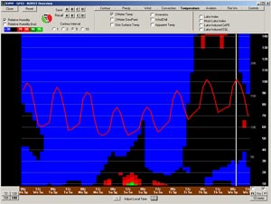

GFS Temperature Forecast for Van Nuys
August 24, 2010 12z
|
This year it wasn't until July 14th that Downtown Los Angeles topped the 90°F mark, and Woodland Hills the 100°F mark. Through mid August we'd had only one short (four day) heatwave. But it's Southern California, and you knew sooner or later temps would soar.
Since the middle of the month temperatures have been above seasonal norms, and particularly so the last couple of days. Monday and Tuesday, Downtown Los Angeles recorded highs of 98°F and 94°F, and Pierce College in Woodland Hills hit 104°F and then a scorching 111°F. This afternoon temperatures downtown have been a few degrees cooler than yesterday, but at Pierce College temps have been just about as hot as yesterday. The good news is an upper level trough is forecast to move onshore in the western U.S. this weekend. In Southern California this will result in a deeper marine layer, and dramatically cooler temperatures.
Intellicast composite radar shows some strong thunderstorm activity in Southern California this afternoon. In some cases hail is indicated, with tops reaching 50,000 ft.
|
|
The rapid cooling of equatorial Pacific SSTs took a bit of a breather at the the beginning of August, with SST departures leveling out in Nino regions 3.4 and 4, and even warming somewhat in Nino regions 1+2 and 3. But subsurface temperatures remained cool, and in the last ten days surface temperatures have once again been on the decrease. Here is a comparison of TAO 5-day SST anomalies for August 14 and August 24. TAO data from August 24 shows SST anomalies of -2°C, or greater, extending from 95°W, nearly to the dateline.
Update 08/27/10. Thursday the high at Downtown Los Angeles (USC) was 87°F. Pierce College in Woodland Hills topped out at 107°F. In the 9:00 hour this morning Pierce College temps are running 11°F to 12°F cooler than yesterday.
Update 08/26/10. Wednesday the high at Downtown Los Angeles (USC) was 90°F. Pierce College in Woodland Hills topped out at 109°F. Today's temps should be a near repeat of yesterday's. Big cool down kicks in on Friday, and continues into Sunday. Looks like inland highs will drop around 10°F (give or take) each day. A warming trend is forecast for next week.
More information concerning Southern California weather can be found using our WEATHER LINKS page.
|