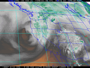

GOES-11 Water Vapor Image
Tuesday June 28, 2011 - 2:30 pm PDT
Tuesday a front associated with an unseasonably strong Pacific low pressure system broke rainfall records in much of the northern half of the state. Precipitation records for the date were broken in numerous locations, including Monterey, San Jose, Oakland, San Francisco, Napa, Sacramento, Redding, Eureka and Crescent City. Here are archived copies of record reports from the San Francisco Bay/Monterey NWS Office and the Sacramento NWS Office.
The front and trough produced a few clouds and cooled temperatures in the Los Angeles area, but I didn't see any reports of rain. Downtown Los Angeles (USC) will end the July 1, 2010 to June 30, 2011 water year with 20.20 inches of rain. This is about 133% of the climate normal of 15.14 inches. According to NWS data Camarillo/Oxnard recorded 139% of normal rainfall, Long Beach 145%, Santa Barbara 169% and Palmdale 105%.
Looks like temperatures will be warming up for the July 4th weekend. Temperatures are expected to reach into the 80s at the coast, 90's inland and 100's in the valleys. Desert areas could reach 110 or higher. Models suggest the possibility of some monsoon moisture moving into the area Sunday or Monday, along with a chance of thunderstorms in the mountains and deserts. Check the NWS Los Angeles/Oxnard Office for the latest forecasts and warnings.
More information about Southern California weather and climate can be found using our WEATHER LINKS page.