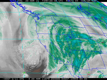

GOES-11 Water Vapor Satellite Image
Sunday, March 20, 2011 at 1:30 p.m.
Running in the rain and wind, and splashing through innumerable puddles, Markos Geneti set a new Los Angeles Marathon record in a time of 2:06:35. It was a remarkable performance, in adverse conditions. From 8:00 a.m. to 12:00 p.m. the Mt. Washington RAWS, near the start of the marathon, recorded 0.59 inches of rain; and the Beverly Hills RAWS near mile 17, recorded 1.27 inches. Periods of heavy rain were reported at Santa Monica Airport, near the finish line, through much of the race. According to a report in the Los Angeles Times sports blog, The Fabulous Forum, thousands of runners were evaluated for hypothermia and 25 runners were hospitalized.
Many rainfall records were set around the area Sunday, with some locations recording as much as one-third of a year's normal rainfall in 24 hours! In the early evening rainfall rates of over an inch an hour were recorded in Woodland Hills and Canoga Park. According to a NWS Storm Report, at 6:14 p.m. a flash flood was reported in Woodland Hills with "mud and debris flowing down the street" and "at least four to five vehicles stuck in flowing water."
Downtown Los Angeles (USC) recorded 2.42 inches of rain yesterday, breaking a record set in 1943. Santa Barbara Airport had its wettest day on record, recording 5.23 inches of rain. Here's an archived copy of the NWS Record Report for March 20, listing some of the rainfall records for the day.
Storm totals in excess of 3 inches have been common in Los Angeles, Ventura, Santa Barbara, and San Luis Obispo counties. Higher totals were recorded in many areas. As of 5:00 p.m. the NWS reported that Van Nuys had recorded 6.74 inches of rainfall, Northridge 6.08 inches, Newhall 7.20 inches, Santa Barbara Airport 6.27 inches, San Marcos Pass 10.72 inches, and Gibraltar Dam 11.73 inches. Here's an archived copy of a NWS report with some rainfall and snowfall amounts from around the area.
Downtown Los Angeles made up its rainfall deficit for the month of March and more, increasing its water year rainfall total to 18.55 inches, or about 123% of normal. This makes the 2010-2011 water year the wettest in Los Angeles during a La Nina over the last 60 years, surpassing the totals recorded during the strong La Ninas of 1955-56 (99% of normal) and 1973-74 (106% of normal), and weak La Ninas of 1967-68 (110%) and 2000-01 (118%).
Sunday's heavy rain appears to have had the earmarks of an atmospheric river event. NRL SSM/I IPW imagery (lower right) shows a pre-frontal band of IPW values of 35-40 kg/m2 impinging the coast, NEDIS blended TPW imagery showed a band of ~25 mm TPW extending some 4000 km to the longitude of Hawaii. A BUFKIT cross section based on 12z NAM data for VNY depicted a low level jet (LLJ) structure coinciding with the period of heaviest rainfall. Research by Dr. F. Martin Ralph, et. al., observed that in atmospheric rivers over the eastern Pacific, 75% of the water vapor transport below 500 mb takes place within the lowest 2.25 km and occurs with LLJ wind structure. In addition in cases where a LLJ is present, there was 50% greater precipitation efficiency.
More information about Southern California weather and climate can be found using our WEATHER LINKS page.