
MIRS IWV All Satellites
December 2, 2012 1800 UTC Preceding 12 hours.
If you were to only look at the Global Wind Oscillation (GWO) for November you might think our 2012-2013 El Nino hadn't flopped. The relative AAM anomaly peaked at about 1.4 around November 20, which is the highest it's been since the El Nino of 2009-2010.
Most of the AAM was added in the NH between 15°N and 30°N. This led to the development of a high amplitude mid-Pacific ridge, and undercutting of the ridge by the westerlies. This enabled a low near the dateline to tap tropical moisture and relay it into the circulation of a large eastern Pacific low. This linkage provided the moisture necessary to create the atmospheric rivers that produced excessive precipitation in Northern and Central California last week.
Over the 5-day period ending Monday morning (December 3) Northern and Central California recorded double-digit precipitation totals with several stations recording rainfall amounts in excess of 15 inches. Here are archived Public Information Statements issued by NWS San Francisco Bay Area/Monterey and NWS Eureka with some of the phenomenal precipitation totals recorded in those areas. This AHPS Precipitation Analysis shows the observed precipitation in the western U.S. for the 7-day period ending Monday morning.
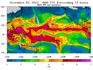
New forecast methods developed by NOAA's ESRL PSD using satellite-derived and GFS medium range forecast data indicated high levels of water vapor transport early Friday and early Sunday. This typically characterizes AR events. This Evaluation of GFS Forecast Fields (PDF) shows the observed Integrated Water Vapor (IWV) for December 2, the corresponding analysis, and the 1-day to 5-day forecasts.
System dynamics were much weaker in Southern California, and the IWV content of the atmospheric rivers was less. (Friday IPW and Sunday IPW). Even so orographically favored areas were still able to wring several inches of rain from the moist flow. From Tuesday night to Monday morning Opids Camp recorded 3.02 inches, White Ledge Peak 4.09 inches, Refugio Pass 4.61 inches, and Rocky Butte 8.51 inches.
Over the same period Downtown Los Angeles (USC) recorded 1.03 inches, bringing the water year total to 1.36 inches. As of today that's 1.08 inch less than normal. Here's an archived copy of a NWS compilation of preliminary rainfall totals in our area.
More information about Southern California weather and climate can be found using our WEATHER LINKS page.