
HPC 3-Day Precipitation Forecast
For the Period Ending 4:00 a.m. Sunday Morning
The transition from a persistent West Coast ridge to a West Coast trough occurred on Monday more or less as forecast by medium range guidance back on February 5. A series of systems and impulses riding up and over a high amplitude Eastern Pacific ridge are expected to continue to produce cool, blustery weather in Southern California with periods of showers and rain into next week.
Precipitation on Valentine's Day was generally limited to areas north of the Los Angeles basin, but was a little more widespread late Monday night into Tuesday morning, with a number of stations in the Los Angeles area recording a few hundredths of an inch of rain.
Wednesday's system was much more energetic. Because of the convective nature of the precipitation, rainfall amounts were extremely variable, ranging 0.25 inch or less to 1.0 inch or more. Downtown Los Angeles (USC) recorded 0.65 inch of rain for the storm, bringing the water year total for Los Angeles to 13.14 inches. This is well above normal for the date, and about 87% of normal for the water year. Here's an archived copy of a NWS tabulation of some rainfall totals for the period 4:00 p.m. Tuesday to 4:00 a.m. Thursday.
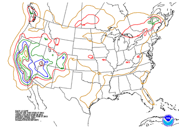
Los Angeles only needs about 2 more inches of rain to top the 100% mark for the water year, and it looks like we could get most of that Friday and Saturday. BUFKIT analysis of 12z NAM data for Van Nuys indicates about 1.6 inches of rain Friday into Saturday, and then another 0.5 inch Saturday night. The HPC 3-day Quantitative Precipitation Forecast for the period ending 4:00 a.m. Sunday also indicates about 2.0 inches of rain in Southern California. This morning's 09z SREF puts the probability of more than 1.0 inch rain for the 24 hour period ending 1:00 p.m. Saturday at about 70%.
Temperature data at the surface and at depth in the equatorial Pacific suggest the La Nina is moderating. The tough question is whether warming will continue into the NH summer, with neutral ENSO conditions prevailing as we move into autumn; or if the ENSO cycle will swing back toward a La Nina state. Since 1949, about half of the first year La Nina episodes continued into a second or third year. At the moment the majority of computer models favor a transition to ENSO neutral or warm conditions by July 2011. Here is a compilation of ENSO Forecasts from the IRI ENSO Quick Look for February 17, 2011. We'll see!
More information concerning Southern California weather can be found using our WEATHER LINKS page.