Previous Page Page 3 of 3 in the LaNina category
# Saturday, 17 July 2010

Click
TAO/TRITON SST & SST Anomaly
July 17, 2010

Following a 26 day stretch in which the temperature at Downtown Los Angeles was below normal 25 of the days, and several lowest maximum temperature records were set around the area, temperatures have soared, and record high temperatures for the date have been recorded at several locations.

On June 30, Downtown Los Angeles ended the water year about 8% above normal. Some stations in the Los Angeles area recorded more than this and some less. There was a wide range of values. For example, Long Beach Airport was about 20% above normal and Santa Barbara Airport about 23% above; but Camarillo Airport reported 31% below normal rainfall. Here's an AHPS graphic showing the percent of normal precipitation in California and the Southwest for the year ending July 1 at 12z.

Equatorial Pacific SSTs have generally continued to cool. According to the CPC's Weekly ENSO Update, issued July 12, the latest weekly SST departures were -1.3°C (Niño1+2), -1.0°C (Niño 3), -0.8°C (Niño 3.4), and -0.4°C (Niño 4). According to the CPC, La Niña conditions occur "when the monthly Niño3.4 OISST departures meet or exceed -0.5°C along with consistent atmospheric features. These anomalies must also be forecasted to persist for 3 consecutive months."

Reflecting the transition from El Nino to La Nina conditions, the Multivariate ENSO Index (MEI) for May-June experienced an unprecedented drop for the time of year, decreasing nearly 1 standard deviation to a value of -0.41. In addition, the Global Wind Oscillation (GWO) has orbited about -2 SD down on the La Nina side of the phase space plot, and with the atmosphere in a generally low momentum state, may be in that neighborhood for a while.

The most recent IRI ENSO Update, released July 15, projects "an approximately 80% probability for continuing La Niña conditions, and a 20% probability for returning neutral ENSO conditions. "

More information concerning Southern California weather can be found using our WEATHER LINKS page.


Saturday, 17 July 2010 19:53:54 (Pacific Daylight Time, UTC-07:00)  #    Disclaimer  |   | 
# Friday, 25 June 2010

Global Wind Oscillation (GWO) April 1, 2010 - June 23, 2010 Click
Global Wind Oscillation (GWO)
April 1, 2010 - June 23, 2010

Equatorial Pacific SSTs have continued to cool and TAO/TRITON data shows -1.0°C or greater anomalies extending from 95°W to beyond 150°W. According to the CPC's Weekly ENSO Update, issued June 21, the latest weekly SST departures were -0.7°C (Niño1+2), -0.6°C (Niño 3), -0.5°C (Niño 3.4), and 0.0°C (Niño 4). An anomaly of -0.5°C in the Niño 3.4 region is the threshold for La Nina conditions.

The Global Wind Oscillation (GWO) has spiraled well into La Niña territory. The global relative atmospheric angular momentum anomaly is at its lowest value since March 2008, during the La Niña of 2007-2008.

Based on equatorial Pacific SSTs, section plots, tradewinds and cloudiness; and the GWO and AAM; a transition to La Nina conditions appears to be underway.

It looks like Downtown Los Angeles (USC) will likely end the July 1 - June 30 water year having recorded 16.36 inches of rain. This is more than an inch above the 1971-2000 annual climate norm of 15.14 inches.

More information concerning Southern California weather can be found using our WEATHER LINKS page.


Friday, 25 June 2010 15:42:31 (Pacific Daylight Time, UTC-07:00)  #    Disclaimer  |   | 
# Saturday, 05 June 2010

Click
Niño Region SST Anomalies

Woodland Hills (Pierce College) topped the 90° mark for the first time this year Memorial Day weekend, and after cooling a few degrees during the week, temperatures are back into the 90's this afternoon. A quick look at temps around the area shows temps near 70 on the coast; 80's to 90's in the valleys, and triple digits in the deserts.

Reflecting the transition to ENSO neutral conditions, the Multivariate ENSO Index (MEI) for April-May declined to 0.54. According to the CPC's Weekly ENSO Update, issued June 1, the latest weekly SST departures are -0.6°C (Niño1+2), -0.4°C (Niño 3), -0.2°C (Niño 3.4), and 0.4°C (Niño 4).

In his May 2010 MEI discussion Klaus Wolter projected the probability of a La Nina event emerging by the end of 2010 at roughly 50%. In it's May 2010 ENSO Quick Look, the International Research Institute for Climate and Society (IRI) put the probability of La Nina conditions from the August-October season through the remainder of 2010 at 42%. We'll see!

Downtown Los Angeles (USC) has recorded 16.36 inches of rain since the water year began July 1. This is more than an inch above the 1971-2000 annual climate norm of 15.14 inches. The water year ends June 30. Climatology and current forecasts suggest it is unlikely that this total will change by more than a hundredth or two before the end of the month.

More information concerning Southern California weather can be found using our WEATHER LINKS page.


Saturday, 05 June 2010 16:22:40 (Pacific Daylight Time, UTC-07:00)  #    Disclaimer  |   | 
# Friday, 14 May 2010

Click
TAO 5-Day Average SST and Anomaly
Period Ending May 14, 2010

During the last month the 2009-10 El Niño has essentially transitioned to ENSO neutral conditions. Over the course of the event, the Multivariate ENSO Index (MEI) peaked in JAN/FEB at 1.5, and the Oceanic Nino Index (ONI) peaked in NDJ at 1.8. The mean 5-day averaged November 1 to March 31 relative AAM anomaly was 0.304. The strongest El Niño forcing appeared to have occurred in late January after the active phase of the Madden-Julian Oscillation (MJO) enhanced El Nino convection in the equatorial Pacific. Here's a chart comparing the 2009-10 El Niño to 17 other warm ENSO episodes that have occurred since 1950.

Dynamical and statistical ENSO model forecasts suggest the possibility that equatorial Pacific SSTs will continue to decline, leading to weak to moderate La Niña conditions by late Summer or Fall. A return to El Niño conditions does not appear likely, but cannot be ruled out. In his May MEI discussion, Klaus Wolter points out that the 1957-1958 El Nino, an analog to the 2009-2010 El Niño, rebounded after dropping into neutral territory.

Downtown Los Angeles (USC) has recorded 16.31 inches of rain since the water year began July 1. This is more than an inch above the 1971-2000 annual climate norm of 15.14 inches. Recent runs of the GFS and ECMWF show a negatively tilted trough deepening and moving onshore early next week. At this point it looks like there's a pretty good chance of showers north of Pt. Conception, but only a slight chance down here. We'll see!

Update 05/18/10. Stations in the Los Angeles area generally recorded under a tenth of an inch from this system. Some isolated totals of about 0.25 inch were recorded in Ventura and Santa Barbara county, and Rocky Butte in San Luis Obispo recorded 0.48 inch. Here is an archived copy of a NWS Public Information Statement with some rainfall totals from around the area.

More information concerning Southern California weather can be found using our WEATHER LINKS page.


Friday, 14 May 2010 19:46:45 (Pacific Daylight Time, UTC-07:00)  #    Disclaimer  |   | 
# Wednesday, 16 December 2009

AHPS Observed Precipitation For 7-days Ending 12/15/09 at 4:00 a.m. PST Click
AHPS Observed Precipitation
For 7-days Ending 12/15/09 at 4:00 a.m. PST

Following several weeks of dry weather, a shift to a wetter pattern brought much needed rain and snow to California this past week. The pattern change was apparently induced by MJO enhancement of El Niño convection in the equatorial Pacific.

Downtown Los Angeles recorded 1.78 inches of rain from Thursday to Sunday, bringing the water year total to 4.81 inches. This is about 2.20 inches above normal for the date. Rainfall totals generally ranged from 2 to 4 inches in the basin and valleys, and 2 to 6 inches in the mountains. Here's an archived copy of a NWS Public Information Statement with rainfall totals from around the area.

Will the current El Niño produce the expected seasonal impacts in Southern California? A new tool that can help gain some insight into the linkage of climate and weather is the Global Wind Oscillation (GWO) phase space plot. Ed Berry repeatedly demonstrated the usefulness of this tool in his blog Atmospheric Insights. Although the blog has been discontinued, its content remains a valuable resource.

The GWO is a recurring subseasonal phenomenon that involves the transport and interchange of momentum in the earth-atmosphere system. It encompasses the MJO and occurs on a similar timescale. Analogous to the MJO phase space plot, but based on a framework of atmospheric angular momentum (AAM), the GWO phase space plot is a measure global relative atmospheric angular momentum and it's tendency. For details, see Weickmann & Berry, 2008.

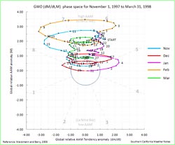
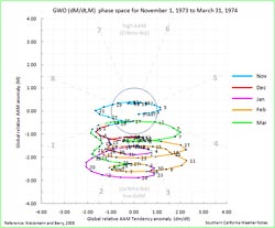
Relative AAM is generally positive during an El Niño and negative during a La Nina. Relative AAM is correlated with rain season precipitation in Southern California*, and can be helpful in assessing potential El Niño impacts. The following November to March GWO phase plots show the distinctly different behavior of the GWO during the strong El Niño of 1997-98, and the strong La Nina of 1973-74:

GWO El Niño 1997-1998 GWO La Niña 1973-1974
GWO El Nino 1997-1998
Click for larger image
GWO La Nina 1973-1974
Click for larger image

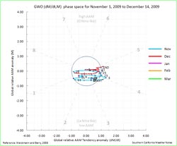
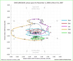
In a decade characterized by quirky El Niños, the El Niño of 2009-10 has been acting like another odd one. From a Southern California perspective, the concern has been that it might be like the El Niño of 2006-07 when Downtown Los Angeles recorded only 3.21" of rain over the water year. In the early stages of the El Niño of 2006 strong convection developed in the Indian Ocean during November, but an MJO did not develop until a second round of Indian Ocean convection occurred in mid December. Relative AAM remained negative, and in terms of the atmosphere, the 2006 El Niño didn't make it to 2007.

This year, Indian Ocean convection did spawn an MJO which eventually enhanced El Niño convection near the dateline. Significant momentum was added to the mid-latitudes of the Northern Hemisphere, energizing the westerlies and contributing to the pattern change that resulted in our recent wet weather. However, the increase in mid-latitude AAM has been mostly offset by negative anomalies at higher latitudes. Following are the GWO phase space plots for the current rain season to date, and the quirky El Niño of 2006-07.


GWO El Niño 2009-2010 GWO El Niño 2006-2007
GWO El Nino 2009-2010
Click for larger image
GWO El Nino 2006-2007
Click for larger image

So where do we go from here?. For at least a few days the storm track has shifted north. It appears the GWO might be starting an orbit that will take it farther into the El Niño side of the phase space. Several MJO forecasts show the next MJO cycle shortcutting it's orbit back into the Western Pacific. In the 6-10 day period, the GEFS ensemble MJO forecast indicates enhancement of equatorial convection around 90E, and suppression (by the MJO contribution) of El Niño convection near the dateline. This could modify any short term response of the El Niño signal and the GWO, once again reducing AAM.

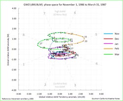
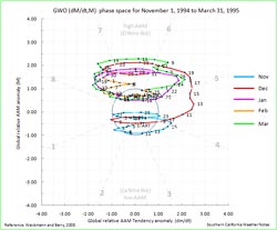
Below are the GWO phase plots for two El Niños with ONI and MEI values comparable to the current El Niño. In the 1986-87 El Niño, November to March AAM averaged 0.02, and it wasn't until February that the GWO climbed out of the AAM doldrums. That water year Los Angeles recorded 7.66 inches of rain. On the other hand, in the 1994-95 El Niño, November to March AAM averaged 0.76. In mid December the GWO began to reflect an ocean-atmosphere coupled El Niño response, and Los Angeles went on to record 24.35 inches of rain for the water year. At the moment it looks like Southern California might not be as dry as 1986-87, but probably not as wet as 1994-95. We'll see!

GWO El Niño 1986-1987 GWO El Niño 1994-1995
GWO El Nino 1986-1987
Click for larger image
GWO El Nino 1994-1995
Click for larger image

*1958-2008 Precipitation/AAM correlation plot generated using US Climate Division Dataset Seasonal Correlation Page.

More information concerning Southern California weather can be found using our WEATHER LINKS page.

Wednesday, 16 December 2009 13:40:43 (Pacific Standard Time, UTC-08:00)  #    Disclaimer  |   | 
# Thursday, 12 March 2009

AHPS Observed Precipitation October 1, 2008 to Date Click
AHPS Observed Precipitation
October 1, 2008 to Date

Compared to last week, GFS and ECMWF runs this week have been much drier in Southern California, with most of the activity focused on the Pacific Northwest. No significant rain is forecast here next week, and both the 6-10 and 8-14 day forecasts project below average precipitation for Southern California.

Recent runs of the GFS show the East Asian jet pumping up a huge, high amplitude ridge in the central Pacific around the dateline, but the resulting downstream trough, jet energy and storm track are forecast to remain above about 40°N.

Model performance has not been the best in recent weeks, and generally suffers during seasonal transitions. However, if the 12z GFS forecast is on the mark, March rainfall for Downtown Los Angeles (USC) would fall well below the 3.14 inch norm. Since normal April rainfall is 0.83 inches, and May only 0.31 inches, beyond March it becomes increasingly unlikely that a big rain event will significantly boost our rainfall total.

Since November 1, Downtown Los Angeles has recorded 8.80 inches of precipitation. This is consistent with the mean November-March precipitation for coastal Southern California during 9 La Niña events from 1948 to the present. (See the composite precipitation map in Weathernotes for October 31, 2008.) The water year total for Los Angeles is now 3.32 inches below normal.

More information concerning Southern California weather can be found using our WEATHER LINKS page.

Thursday, 12 March 2009 07:40:32 (Pacific Standard Time, UTC-08:00)  #    Disclaimer  |   | 
# Friday, 31 October 2008

Intellicast Composite Radar Friday, October 31, 2008 - 9:30 a.m. PDT Click!
Intellicast Composite Radar
Friday, October 31, 2008 - 9:30 a.m. PDT

Downtown Los Angeles (USC) happened to be under the right cloud yesterday, and recorded 0.02 inch of rain. There's a continuing chance of showers in Southern California through the weekend. The area could use some rain. The last storm to produce more than a couple tenths of inch of rain at Downtown Los Angeles was back on February 24, 2008 -- more than eight months ago.

Last year, California's rain season might have been scripted by Dr. Jekyll and Mr. Hyde. Lowland rain totals and the Sierra snowpack were well above normal through the end of February, and then the spigot was turned off. The storm track shifted north, and California had its driest March to May on record. (The March 29, 2008 post in Ed Berry's Atmospheric Insights blog describes the events that may have led to and maintained this shift.)

Which rain season personality will emerge this Winter? Earlier this year the equatorial Pacific tried to transition to El Nino, but the atmosphere didn't cooperate. As measured by the Multivariate ENSO Index (MEI), the ENSO state has returned to the weak La Nina threshold. And as measured by the Global Wind Oscillation (GWO), an uncooperative atmosphere has continued to cycle through a La Nina base state.

This suggests a winter precipitation outlook with a La Nina flavor -- similar to last year. This precipitation map, generated by the ESRL-PSD Composite ENSO plots page, shows the mean November-March precipitation for the U.S. during 9 La Niña events from 1948 to the present. The average La Niña rainfall indicated for coastal Southern California is in the 7.0-10.5 inch range. Last season's November-March rainfall in Downtown Los Angeles was about 12 inches.

Here's the current Nov-Dec-Jan precipitation outlook issued October 16 by the Climate Prediction Center. The "EC" means an equal chance of below normal, near normal, or above normal precipitation. The IRI Multi Model Seasonal Forecast for Nov-Dec-Jan is similar. We'll see!

Update 11/4/08. Here are the NWS Public Information Statements with preliminary rainfall totals for the period from Friday evening to Sunday morning, and from overnight last night to 10:00 a.m. this morning. The current Climate Prediction Center 6-10 day and 8-14 Precipitation Outlooks project below normal rainfall for Southern California. In Atmospheric Insights, Ed Berry paints a scenario with an extended North Pacific Jet collapsing into a strong western U.S. trough in the week 2-3 timeframe. We'll see!

Update 11/1/08. Did a trail run this morning in the Pt. Mugu State Park Area. Over the course of 3+ hours watched 2-3 waves of convection march northeast from the Santa Barbara Channel across the Oxnard Plain. We were showered on a few times, but were very happy to be east of these training T-storms and heavy rain. Here is a NWS Public Information Statement with some rainfall totals as of 11:00 a.m.

More information concerning Southern California weather can be found using our WEATHER LINKS page.

Friday, 31 October 2008 16:34:21 (Pacific Standard Time, UTC-08:00)  #    Disclaimer  |   | 
# Thursday, 01 May 2008

TAO Five Day Depth Average Temperature 05/01/08 Click!
TAO Five Day Depth Average Temperature 05/01/08

In it's April 30 ENSO Wrap-Up, the Australian Bureau of Meteorology characterizes Pacific climate patterns as being generally neutral, "with the majority of indicators returning to near-normal levels." The April 28 ENSO Update from the CPC suggests that La Niña will continue through May-July 2008, but many of the factors discussed indicate general weakening of the cold ENSO episode.

We've had only a smattering of rain at Downtown Los Angeles since 0.46 inch was recorded back on February 24. A miniscule 0.01 inch was recorded on March 15, and 0.04 inch on April 2. These NOAA/NWS AHPS Precipitation Analyses map the 60 day Departure from Normal Precipitation and 60 day Percent of Normal Precipitation for the southwestern U.S., as of April 30, 2008.

As of May 1, the water year rainfall total for Downtown Los Angeles (USC) stands at 13.42 inches. This is 90% of the 1921-2006 average of 14.87 inches. According to the 1921-2006 dataset, the average amount of precipitation in May and June has been 0.3 inch and 0.1 inch, respectively. Today's NWS 6-10 Day and 8-14 Day Precipitation Outlooks for Southern California continues to indicate Normal precipitation. We'll see!

More information concerning Southern California weather can be found using our WEATHER LINKS page.

Thursday, 01 May 2008 17:11:58 (Pacific Daylight Time, UTC-07:00)  #    Disclaimer  |   | 
# Tuesday, 05 February 2008

Drought Monitor Classification Change for Water Year Ending January 29, 2008 Click!
Drought Monitor Classification Change
Water Year Ending January 29, 2008

Sunday's storm added more rain to Southern California's unexpectedly wet water year totals, and more snow to the Sierra snowpack. This rain season western storms have reduced drought classifications by as much as three steps in some areas of California and four in Arizona.

As of February 4, Downtown Los Angeles (USC- KCQT) has recorded 12.13 inches of rain since July 1-- about 4.5 inches above normal for the date. Here is an archived PDF of a NWS Public Information Statement with some preliminary rainfall totals for Sunday's storm.

Sierra snow course measurements for February 1 are coming in and manual measurements are confirming what automatic snow sensors have already reported -- that the Sierra snowpack is well above normal for the date.

Will the wet western weather continue? The GFS and ECMWF medium range models, and NCEP and PSD ensembles are forecasting a generally quiescent, rain free period for Southern California over the next several days, and into the extended period. Today's NWS 6-10 Day and 8-14 Day Precipitation Outlooks for Southern California are indicating Below Normal precipitation.

However, there are suggestions (see Atmospheric Insights) that sometime around February 15-20, the currently active MJO may more or less phase with the GWO, and amplify La Nina to produce a energetic, extended Pacific jet and west coast trough, similar to what occurred around January 3, 2008. We'll see!

More information concerning Southern California weather can be found using our WEATHER LINKS page.

Tuesday, 05 February 2008 21:30:08 (Pacific Standard Time, UTC-08:00)  #    Disclaimer  |   | 
# Monday, 07 January 2008

HPC 5 Day Precipitation Forecast for the period ending January 8, 2008 4:00 a.m. PST Click!
AHPS 7 Day Precipitation Analysis
Ending January 7, 2008 4:00 a.m. PST

The last of a series of storms that have been producing rain and snow in the western U.S. the past several days moved eastward and (mostly) out of the region today. According to preliminary NWS data, Downtown Los Angeles (CQT) recorded 2.00 inches of rain in the course of the event, bringing its water year total to 4.41 inches -- 1.54 inches above normal.

Precipitation totals in the Los Angeles area from Friday morning to this morning generally ranged from 2-5 inches in the basin and valleys, and from 5 to 10 inches or more in the local foothills and mountains. San Marcos Pass, near Santa Barbara recorded nearly 11 inches of rain, and OPIDS Camp, near Mt. Wilson, recorded nearly 13 inches of precipitation. Here is an archived copy of a NWS Public Information Statement with preliminary rainfall totals for the rain event, and an AHPS Precipitation Analysis of California precipitation for the 7 day period ending 4:00 a.m. this morning.

According to today's Summary of Snow Water Equivalents from California Cooperative Snow Surveys, the series of storms increased the Sierra Snowpack to 111% of normal for the date -- up from 60% at the end of 2007.

Another fast moving shortwave is forecast to primarily affect areas north of Pt. Conception Tuesday into Wednesday, with only a small chance of showers in the Los Angeles area.

So far this rain season, Southern California has dodged a La Nina bullet. This AHPS Precipitation Analysis for the water year to date indicates much of the area having received near normal to above normal precipitation. Even though the Climate Prediction Center's revised precipitation outlook for January, issued December 31, indicates above normal precipitation in the western U.S., the JFM Precipitation Outlook, issued December 20, remains pessimistic. We'll see!

Updated January 10, 2008. The ESRL-PSD Composite ENSO plots page was updated today to correct an issue that resulted in the wrong set of years being used for its Winter La Nina composites. As a result the La Nina composite precipitation map in the October 9, 2007 Weathernotes has been updated. Note that the average La Niña rainfall indicated for coastal Southern California is in the 7.0-10.5 inch range, rather than the 10-15 inch range previously indicated in the ESRL-PSD graphic.

More information concerning Southern California weather can be found using our WEATHER LINKS page.

Monday, 07 January 2008 19:44:55 (Pacific Standard Time, UTC-08:00)  #    Disclaimer  |   | 
# Thursday, 20 December 2007

Intellicast Composite Radar - December 18, 2007 3:00 p.m. PST Click!
Intellicast Composite Radar
December 18, 2007 3:00 p.m. PST

According to preliminary NWS data, Downtown Los Angeles (CQT) recorded 1.24 inches of rain as a result of Tuesday night's storm, bringing the water year total to 3.69 inches. This amount is about 3/4 inch above normal for the date, and exceeds the 3.21 inch total recorded at Los Angeles during the record setting dry water year of 2006-2007.

Rainfall totals around the Los Angeles area generally ranged from about 0.75 to 1.25 inch in the basin and surrounding valleys, with as much as 1.5 to 3.0 inches (or more) recorded in some foothill and mountain locations. Here's a copy of a NWS Information Statement listing some rainfall totals for the storm.

In terms of percent of normal rainfall over the past 90 days, Southern California and the Desert Southwest have fared better than might be expected during a La Niña. The snowpack distribution in the Sierra is also somewhat unusual for a La Niña. Today's Summary of Snow Water Equivalents reports that the Sierra Southern Section snowpack is at about 77% of normal for the date, while the Central and Northern sections are at 53% and 61% of normal.

Today's NWS 6-10 Day Outlook projects above normal precipitation in Southern California, while the the 8-14 Day Outlook projects normal precipitation. We'll see!

More information concerning Southern California weather can be found using our WEATHER LINKS page.

Thursday, 20 December 2007 19:59:18 (Pacific Standard Time, UTC-08:00)  #    Disclaimer  |   |