|
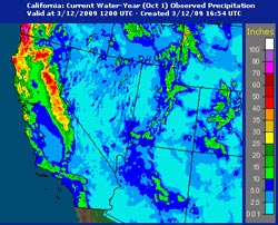

AHPS Observed Precipitation
October 1, 2008 to Date
|
Compared to last week, GFS and ECMWF runs this week have been much drier in Southern California, with most of the activity focused on the Pacific Northwest. No significant rain is forecast here next week, and both the 6-10 and 8-14 day forecasts project below average precipitation for Southern California.
Recent runs of the GFS show the East Asian jet pumping up a huge, high amplitude ridge in the central Pacific around the dateline, but the resulting downstream trough, jet energy and storm track are forecast to remain above about 40°N.
Model performance has not been the best in recent weeks, and generally suffers during seasonal transitions. However, if the 12z GFS forecast is on the mark, March rainfall for Downtown Los Angeles (USC) would fall well below the 3.14 inch norm. Since normal April rainfall is 0.83 inches, and May only 0.31 inches, beyond March it becomes increasingly unlikely that a big rain event will significantly boost our rainfall total.
|
|
Since November 1, Downtown Los Angeles has recorded 8.80 inches of precipitation. This is consistent with the mean November-March precipitation for coastal Southern California during 9 La Niña events from 1948 to the present. (See the composite precipitation map in Weathernotes for October 31, 2008.) The water year total for Los Angeles is now 3.32 inches below normal.
More information concerning Southern California weather can be found using our WEATHER LINKS page.
|