|
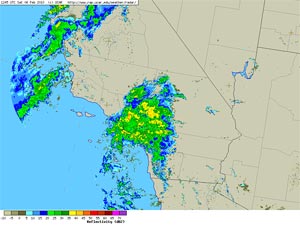

UCAR NEXRAD Regional Composite Image
February 6, 2010 - 4:45 a.m. PST
|
Wet antecedent conditions and heavy rain early this morning combined to amplify the amount of runoff from our latest Winter storm. In addition to localized street flooding, mud and debris flows have occurred in the vicinity of the Station Fire burn area. The trough associated with the system, and a second frontal band are moving onshore this afternoon, and are producing some additional rainfall in the Los Angeles area. Please refer to www.weather.gov/losangeles for the latest warnings and weather information.
Yesterday's runs of the NAM/WRF did a pretty good job of forecasting the area of enhanced precipitation that developed overnight in Southern California. BUFKIT analysis of 12z NAM data from yesterday generated about 2.4 inches of precipitation at KLAX for the 24 hr. period ending early this morning. According to preliminary NWS data, as of 10:00 a.m. LAX had recorded 2.31 inches for the storm, and Downtown Los Angeles (USC) had recorded 2.84 inches. The water year total rainfall for Los Angeles is now about 5 inches above normal. Here is a NWS Public Information Statement with rainfall totals from around the area. (Link will be updated as revised totals become available.)
|
|
The recent enhancement of El Nino convection in the equatorial Pacific by the Madden-Julian Oscillation (MJO) has triggered a strong atmospheric response. A Global Wind Oscillation (GWO) phase space plot shows large increases in relative atmospheric angular momentum (AAM) and AAM tendency. As a result of this increase, the average relative AAM anomaly for the rain season to date is now positive. As mentioned in this post from December 2009, relative AAM is correlated with rain season precipitation in Southern California. This suggests an increased likelihood of wet weather in Southern California in the medium range outlook period.
So what happens next? The ECMWF and GFS projections have not been particularly consistent. At the moment, it looks like a shortwave trough could affect Southern California in the Tuesday evening or Wednesday timeframe and then again Friday. We'll see how the week develops.
More information concerning Southern California weather can be found using our WEATHER LINKS page.
|