|
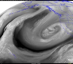

UW GOES-11 Water Vapor Image
January 25, 2008 9:00 a.m. PST
|
Computer weather simulations can be impressive, but sometimes the models just don't get it. That was the case overnight and into this morning as the Los Angeles area was hit by thunderstorms, heavy rain, and hail. Rainfall totals around the area generally ranged from about 1.5 to 3 inches, with some foothill and mountain location recording much more. OPIDS Camp, near Mt. Wilson in the San Gabriel Mountains recorded 6.27 inches for the 24 hour period ending at 8:00 this morning.
As has been the case several times this rain season, the GFS provided a better rainfall guesstimate than the NAM, forecasting 1.5 inches at Los Angeles through today, compared to the NAM's paltry 0.5 inch. Here are a CNRFC graphic of 24 hour rainfall totals in the Los Angeles area, a PDF of some preliminary Los Angeles County rainfall totals, and another PDF of a NWS Public Information Statement with some preliminary rainfall totals for the ongoing rain event. Several stations have recorded more rain since Monday than during all of last year's rain season.
|
|
Now attention turns back to the large upper level low spinning off the coast. The extensive circulation around this low is forecast to interact with the southern branch of the jet stream and an associated plume of sub-tropical moisture, and draw the jet and moisture into Southern California overnight on Saturday. According to NAM, GFS and high resolution NMM and ARW, the strongest dynamics and precipitation are forecast for Northern and Central California, however heavy precipitation is also expected in Southern California.
The 12z NAM and GFS are in better agreement than in recent days, projecting about 2.5 inches at Los Angeles from early Saturday morning to early Monday morning, with peak rain rates around 1:00 a.m. on Sunday. A BUFKIT analysis of 12z VNY data shows a strong, saturated, veering, southeasterly to southerly inflow, turning southwest over a six hour period from about 9:00 p.m. Saturday to 3:00 a.m. Sunday. This could produce significant orographic enhancement of precipitation on favored foothill and mountain slopes. Wet antecedent conditions at the lower elevations, and the possibility of rain on snow at the middle elevations, could increase runoff.
Update 01/26/08. Today's models appear to be indicating stronger dynamics in the south with more embedded vorticity, more diffluence aloft, and more favorable jet stream dynamics, but the 18z NAM and GFS are still cranking out about 2.3 inches at Los Angeles, beginning this evening, continuing through Sunday night, and tapering off Monday morning. Strong southerly inflow could produce much more than this in the foothills and mountains, particularly on south facing slopes. As the upper level low moves onshore on Sunday afternoon, thunderstorms could produce very heavy rain in areas where the soil iis already saturated.
Here is a NWS Public Information Statement with the preliminary rainfall totals for the period 4:00 p.m. Monday afternoon, to 4:00 p.m. Friday afternoon.
Please refer to your local NATIONAL WEATHER SERVICE FORECAST OFFICE for official forecasts and warnings.
More information concerning Southern California weather can be found using our WEATHER LINKS page.
|