|
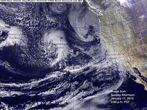

NRL GOES Day/Night Image
January 17, 2010 - 3:00 p.m. PST
|
So many systems are moving through Southern California so fast, I thought I better check some satellite images and make sure I had my count right. Here's a NRL GOES Day/Night image from Sunday afternoon that shows system #1 moving into Southern California, and systems #2 and #3 out in the Pacific.
Then here is a NRL GOES Day/Night image from midday yesterday (Monday) that shows system #2 hammering Southern California. The combined rainfall totals from system #1 and system #2 are listed in this archived copy of NWS Public Information Statement issued this morning.
Today's system is number three in the series that started Sunday afternoon. Intellicast.com composite radar shows the N-S aligned frontal band moving onshore this morning. Current QPF forecasts suggest precipitation amounts ranging from about 0.75 inch to 1.5 inches with higher amounts possible in the foothills and mountains, or in heavy downpours associated with thunderstorms. This system is colder and more convective than previous systems in the series, so precipitation amounts may vary widely.
|
|
System #3 is a transitional system, as a large upper and lower level low complex and circulation develops in the Northeastern Pacific. The resulting system #4-5 looks to be the culminating event of the series, and is forecast to produce rain on Wednesday, and then again Thursday into Friday. BUFKIT analysis of 12z NAM data generates more than 3.5 inches of rain in the central San Fernando Valley from Wednesday morning through Friday afternoon. If the NAM forecast verifies, even higher totals could occur in orographically favored foothills and mountain locations.
Please refer to www.weather.gov/losangeles for the latest warnings and weather information.
More information concerning Southern California weather can be found using our WEATHER LINKS page.
|