|
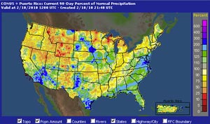

AHPS 90 Day Precipitation (Percent of Normal)
February 10, 2010 4:00 a.m. PST
|
Yesterday's cold upper level low behaved about as expected, following a track just off the coast. Because of the convective nature of the system, rainfall amounts varied from under 0.25 inch to over 1.0 inch in some foothill and mountain locations. About a foot of snow was reported at the mountain resorts. Here is a NWS Public Information Statement with precipitation totals from around the area. Downtown Los Angeles (USC) recorded 0.44 inches for the storm, increasing the water year total to 13.2 inches. The is 4.78 inches above normal for the date.
Compared to the AHPS 90 Day Precipitation map from about 40 days ago, a fairly typical El Niño precipitation pattern has emerged in the West. Medium range models are projecting about a 7-10 day break in what has turned out to be a busy rainy season in Southern California. Assuming these forecasts verify, such a break could not come a better time for those threatened by mudslides and debris flows. The recent enhancement of El Niño convection by the MJO, and the ongoing phase 6-7-8 transition of the GWO might have resulted in a wetter pattern, and this has occurred in similar circumstances in past El Ninos.
|