|
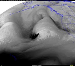

UW GOES-11 Water Vapor
February 22, 2008 1:00 pm PST.
|
Rapidly intensifying Pacific low pressure system approaching the west coast looks very impressive on satellite images this afternoon, with strong upper and low level jet dynamics, a good moisture feed, and a classic baroclinic leaf.
The system is forecast to be filling as it moves onshore, but a very strong jet max moving through the base of the trough should keep the dynamics interesting. In any case, significant rain is expected throughout much of California over the weekend, with heavy snow in the Sierra.
Southern California is forecast to be on the southern margin of the action, however in keeping with the wet trend this rain season, the 18z GFS is forecasting about 1.5 inches of rain at Los Angeles from midday Saturday through Sunday afternoon, and the 18z NAM about 1.0 inch. A moderately strong mid-level southerly to southwesterly inflow should increase precipitation amounts in favored foothills and mountain locations.
|
|
Precipitation totals resulting from the passage of the second trough yesterday afternoon into this morning have ranged from about 0.25 to 0.75 inch in the Los Angeles area, with up to about 1.0 inch recorded at some locations. Here is an archived PDF of a NWS Public Information Statement with some preliminary rainfall totals as of 4:00 p.m. Isolated showers have continued to pop up around the Los Angeles area much of the day, but are forecast to be ending in most areas this evening.
Downtown Los Angeles (USC- KCQT) recorded 0.19 inches of rain Thursday, bringing the water year total (since July 1) to 12.84 inches. We're still at a deficit for the month of February, but remain above normal for the water year to date. Much of the February deficit may be erased by Monday. We'll see!
Following this series of systems, a ridge is forecast to build in, resulting in generally fair, Spring-like weather for at least several days. Today's NWS 6-10 Day and 8-14 Day Precipitation Outlooks for Southern California continues to indicate Below Normal precipitation.
More information concerning Southern California weather can be found using our WEATHER LINKS page.
|