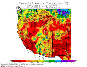

Western U.S. Precipitation - Percent of Average (WRCC)
July 1, 2012 to June 30, 2013.
Downtown Los Angeles (USC) finished the water year (July 1 to June 30) with only 5.85 inches of recorded rainfall, making it the sixth driest water year since recordkeeping began in 1877. With a deficit of over 9 inches, the water year rainfall total was about 39% of the norm of 14.93 inches. This tabulation of Rain Season Totals from the NWS/Oxnard shows rainfall totals around the area ranged from a low of 14% of normal at Palmdale Airport to a high of 54% at Long Beach Airport and LAX.
As this WRCC precipitation map for the period July 1 to June 30 shows, below average precipitation was not limited to Southern California. If it were not for heavy precipitation related to atmospheric river events in late November/early December there would be even more red on the map.
It has been even drier since January 1. For example, since January 1 Downtown Los Angeles has received only 25% of normal rainfall; Burbank 21% of normal; LAX 30% of normal; Santa Barbara 28% of normal; and Palmdale 19% of normal. Surprisingly, rainfall totals for Los Angeles since January 1 are only the ninth driest on record. The driest January-June on record was 1972 when 0.26 inch was recorded. And guess what -- we went on to have a very wet rain season in 1972-73 with 21.26 inches of rain in Los Angeles!
As dry as it's been in the Los Angeles area since the first of the year, it has been drier at some locations in the San Francisco Bay Area. Remarkably, LAX has had more rain than SFO, and Burbank Airport in the San Fernando Valley has had more rain than Napa Airport in the Napa Valley!
More information about Southern California weather and climate can be found using our WEATHER LINKS page.