
UCAR NAM 12z Analysis 10/14/15
Click for Animation of Retrograding Upper Low
Recall that storm a week ago Monday that blasted down the West Coast and into the Southland? The Los Angeles County mountains received as much as two inches of rain; Downtown Los Angeles (USC) recorded 0.45 inch of rain; and the Sierra got a good shot of snow. (Here are some precipitation totals for that storm from the NWS Los Angeles/Oxnard and the NWS San Diego.)
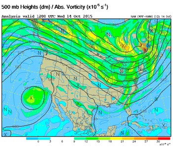
Well, surprise, surprise that upper low isn't done with us yet! After a multi-day circuit into Arizona, Mexico and the Eastern Pacific, the low is now sitting off the coast of Southern California and forecast to move over the area on Thursday. The result is a chance of showers and thunderstorms today, Thursday and possibly Friday, particularly in the mountains. We'll see!
More information about Southern California weather and climate can be found using our WEATHER LINKS page.