|
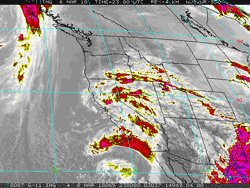

GOES-11 IR Satellite Image
March 6, 2010 - 3:00 p.m. PST
|
As forecast, an energetic upper low skirted the Los Angeles area yesterday on its way south into northern Baja, Mexico. As the low moved south, a vorticity lobe spinning around the low arced into the Southern California coast, producing rain, thunderstorms, waterspouts, and blustery winds.
Rain amounts were variable, generally ranging from about 0.25 inch to 0.75 inch around the Los Angeles area. Indicative of the convective nature of the precipitation, Downtown Los Angeles (USC) recorded 0.42 inch, while a few miles away LAX recorded only 0.18 inch for the storm. The water year total for Downtown Los Angeles now stands at 14.66 inches -- only 0.48 inch less than the annual norm of 15.14 inches. Here is an archived copy of NWS Public Information Statement with some more rainfall amounts for this rain event.
|
|
Reflecting the enhancement of El Niño by the MJO at the end of January, the Multivariate ENSO Index (MEI) for January-February has increased to 1.5. As discussed by Klaus Wolter, MEI originator, this is the highest value of the Jan-Feb MEI since the strong El Niño of 1997-1998, and the fifth highest MEI value for Jan-Feb since 1950. This places the El Nino of 2009-10 in the top 10% of MEI rankings for the season since 1950, and above the "strong" El Niño threshold, as measured by the MEI. Here is a chart comparing the current El Niño to others since 1950.
The increase in the MEI corresponds to the increase in relative AAM since mid January and underscores the potential role of the Global Wind Oscillation (GWO) in assessing the response of the atmosphere to El Niño. It also reinforces the notion that the El Niño phenomena is more than just warm SSTs in the central equatorial Pacific. As we've seen several times in recent years, warm SST anomalies in the Niño 3.4 region alone are not sufficient for evaluating an El Niño and its potential impacts.
More information concerning Southern California weather can be found using our WEATHER LINKS page.
|