|
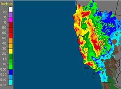

AHPS Observed Precipitation
For 7-days Ending 10/15/09 at 5:00 a.m. PDT
|
A potent early season Pacific storm carrying the remnants of West Pacific typhoon Melor has hammered California, setting numerous rainfall records, increasing stream flows, and producing heavy snow at the higher elevations of the Sierra.
Several stations, including some in Southern California, recorded precipitation totals exceeding 10 inches. In Santa Barbara County, San Marcos Pass recorded 10.32 inches. In Ventura County Nordoff Ridge recorded 10.04 inches and White Ledge Peak 10.87 inches. Precipitation amounts in Los Angeles County generally ranged from 1 to 3 inches, with orographically favored foothill and mountain locations receiving the higher amounts. Little rain fell in Palmdale and Lancaster because of a pronounced rain shadow effect. Downtown Los Angeles (USC) received 2.03 inches. Here's an archived copy of a NWS Los Angeles/Oxnard Public Information Statement with some rainfall totals for the storm from around the area.
|
|
A number of rainfall records for October 13 and 14 fell to the storm, including those for Paso Robles, Santa Maria, Santa Barbara Airport, WFO Oxnard, Burbank Airport, Pierce College in Woodland Hills, LAX, Santa Monica Pier, San Gabriel, and Long Beach Airport. Many of the records broken were set in 1957 and 1968 -- both El Niño years with above average rainfall at Los Angeles.
More information concerning Southern California weather can be found using our WEATHER LINKS page.
|