|
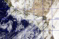

NRL GOES Visible/IR Satellite Image
June 5, 2009 8:00 a.m. PDT
|
Instability and moisture associated with a very late season upper level low produced more rain in Southern California Friday, setting a record for June rainfall at Santa Barbara Airport.
Downtown Los Angeles (USC) recorded a total of 0.13 inch of rain Friday. The rainfall increased the water year precipitation total for Los Angeles to 9.08 inches, which is 6.05 inches below normal. Santa Barbara Airport recorded 0.51 inch, setting not only a new record for the date, but for any day in June, as well as for the total amount of rain in June. Here's an archived copy of a NWS Public Information Statement with some preliminary rainfall totals from around the area as of 5:00 p.m. Friday.
|
|
The April-May Multivariate ENSO Index (MEI) value (released today) has increased by 0.54 to +0.34. As discussed by MEI originator, Klaus Wolter, the 3-month rise of the MEI since January-February is the 4th highest on record for this time of year, exceeded last by the strong Niño of 1997. According to Dr. Wolter, if next month's MEI rank is at least the same as this month (37th), "it would be unprecedented for it to drop below that high-neutral ENSO-phase range by the end of 2009, virtually excluding a return to La Niña, based on the MEI record since 1950." We'll see!
More information concerning Southern California weather can be found using our WEATHER LINKS page.
|