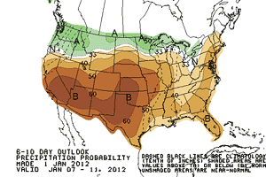

CPC 6-10 Day Outlook Precipitation Probability
Issued Sunday, January 1, 2012
There's been no rainfall recorded at Downtown Los Angeles (USC) since December 17 when 0.01 inch recorded. Los Angeles ended December with 1.01 inch of rain. This is less than half of normal for the month and far less than last December's deluge of 10.23 inches.
Even though December 2011 was somewhat dry, it comes nowhere near setting a record. Since 1877 there have been eight Decembers in which no rain was recorded, and 44 Decembers with 1.01 inches of rain or less.
Downtown begins 2012 with a water year rainfall total of 3.76 inches. Last year we would have said this was near normal, but using the new normals derived from 1981-2010 data the total is 0.56 inch below normal. It has been several years since Downtown Los Angeles (USC) recorded below normal rainfall for the first six months of the water year. The last time was July 1 to December 31, 2007.
In a word the weather for the Rose Parade is expected to be SPECTACULAR. The current NWS point forecast for Pasadena is calling for an overnight low Sunday-Monday of 54 and a high Monday of 83. Click here for the latest NWS forecast for Pasadena.
The MJO has been relatively active this autumn and after going on a two week holiday appeared to be more coherent as it moved into the Western Pacific between Christmas and New Year's. However the NCEP GEFS and several other models forecast the MJO to rapidly diminish in amplitude and eastward propagation.
At the moment the precipitation outlook continues to be on the dry side. We'll see!
The November 30 - December 1, 2011 downslope windstorm felled thousands of trees, produced multi-day power outages and resulted in millions of dollars of damage in valley communities along the San Gabriel Mountains. An initial analysis of the conditions leading up to the event suggest a combination of factors contributed to the strength of the winds. Among them were a highly amplified and energetic north-south upper flow which was evolving into a cutoff upper low over southeastern California; a deepening surface low south of Las Vegas; cold air advection; and a possible inversion near mountain-top level.
More information about Southern California weather and climate can be found using our WEATHER LINKS page.