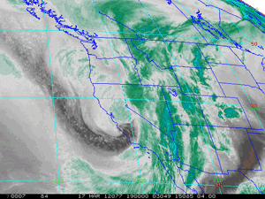

GOES-15 Water Vapor Image
Saturday, March 17, 2012 at 12:00 pm PDT
Updated 03/29/12. Edited to include the rainfall total from October 5 in the Downtown Los Angeles rainfall comparison.
Although there were scattered showers throughout much of Southern California Sunday morning, the Los Angeles Marathon beat the 70/30 odds for measurable rain and stayed dry. Given the cool and breezy conditions, I'm sure runners were glad the precipitation forecast worked out on the dry side!
According to KCQT data Downtown Los Angeles (USC)recorded 0.76 inch for the storm, bringing the water year total to 5.98 inches, which is 46% of normal for the date. This was less than the 1.15 inch recorded Downtown on October 5, the 0.90 inch recorded on November 20, and the 0.96 inch recorded December 12-13, but in some areas Saturday's storm was wetter than any of these storms.
Because of the very strong southwesterly inflow that accompanied the storm, upslope precipitation enhancement produced some impressive totals in the foothills and mountains. For example, West Fork Heliport recorded 3.82 inches, OPIDS Camp 4.49 inches, Mt. Baldy 3.76 inches, and Nordhoff Ridge 5.32 inches. Here are some preliminary rainfall totals from around the area compiled by the NWS, and a snapshot of a Ventura County Watershed Protection District Google Map (PDF) with some additional rainfall totals.
Here are a NEXRAD regional radar image, water vapor satellite image, IR satellite image and RAMDIS visible satellite image of the system at noon Saturday. The parent low north of Pt. Conception is beautifully structured and there is strong convection associated with the frontal boundary south of the Los Angeles.
On a run in the Santa Monica Mountains Sunday morning, I found melting graupel in the Santa Monica Mountains at an elevation of about 2300' along Castro Mtwy about a mile east of Castro Peak. This cell that appears to be the best candidate for the producing the graupel is shown in this KVTX NEXRAD radar image from about 9:00 am PDT Saturday morning.
Both the GFS and ECMWF medium range models show a trough evolving into an upper level low just off the Central California coast this weekend. It's too early to put much credence in the forecast, but some precipitation in the Saturday to Monday timeframe looks like a possibility. We'll see!
More information about Southern California weather and climate can be found using our WEATHER LINKS page.