|

AHPS Precipitation Analysis
For Week Ending 12/16/08 4:00 a.m.
|
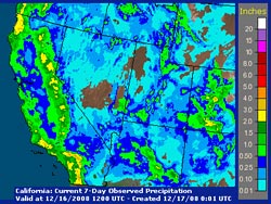
An intense upper level low, fed in part by moisture that originated in the subtropical mid-Pacific, produced widespread rain in Southern California, with snow at the higher elevations. Precipitation totals generally ranged from about 1 to 3 inches, and new rainfall records for December 15 were set at LAX, UCLA, Long Beach, San Gabriel and Santa Barbara. Here are some preliminary rainfall totals from the NWS.
A very cold core upper level cutoff low is currently spinning off the California coast. A GOES sounding from this afternoon indicated a temperature of -33°C at the 500 mb level and significant instability. The low is forecast to move onshore over the next 24 hours, and slight changes in its trajectory could have a big impact on precipitation amounts and intensity.
|
|
The NAM/WRF has been quite a bit drier in the Los Angeles area than the GFS, with the heaviest precipitation occurring south of the basin. The latest (00z) run of the NAM appears to be wetter in the Los Angeles area than runs earlier today. With such cold temperatures aloft, heavy rain and strong thunderstorms are a possibility, particularly wherever the low moves onshore. BUFKIT analysis of PMD and VNY data suggests the snow level could drop to 2000-2500 ft., perhaps lower in heavy showers. We'll see!
More information concerning Southern California weather can be found using our WEATHER LINKS page.
|