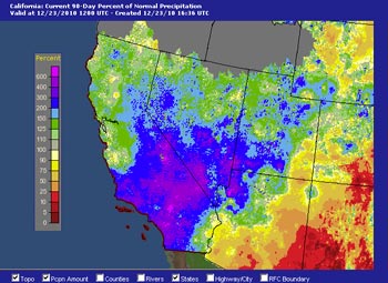

AHPS Precipitation (Percent of Normal)
For 90 Days Ending December 23, 2010 at 4:00 a.m.
After producing phenomenal rainfall totals in Southern California and snowfall totals in the higher elevations of the Sierra, the Pacific low and trough responsible for days and days of wet weather has finally moved east.
Some stations recorded more rain in the last 7 days that would normally be recorded over an entire year. Precipitation amounts over 10 inches were common, and several stations recorded over 20 inches. Tanbark, in the San Gabriel Mountains recorded 24.7 inches, NF Matilija in the Ventura Mountains recorded 24.09 inches, and Lytle Creek in the San Bernardino Mountains recorded an astonishing 26.35 inches!
Here's are snapshots of provisional 7-day rainfall totals in Ventura County and 7-day rainfall totals in Los Angeles County from the Ventura County Watershed Protection District ALERT Map Viewer; and a snapshot of provisional 7-day rainfall totals from the NWS San Diego's Experimental Rainfall Summary Display. And here are archived copies of NWS precipitation summaries with preliminary rainfall totals from the NWS Los Angeles/Oxnard and NWS San Diego offices.
The remarkable amount of rainfall makes December 2010 one of the wettest on record in Southern California. According to preliminary NWS data Downtown Los Angeles (USC) has recorded 8.52 inches of rain so far this December. This ranks it as the third wettest December in Los Angeles since recordkeeping began in 1877, exceeded only by December 1889 (15.8 inches) and December 2004 (8.77 inches). With additional rain a possibility, December 2010 only needs 0.25 inch to surpass 2004. For more detailed info see "A Look at the Record-Breaking Week of Rainfall" a PDF from the NWS Los Angeles/Oxnard.
The Sierra recorded gargantuan snowfall totals, with some of the largest being in the Southern Sierra. In the last week the snow sensor at Farewell Gap recorded 22.6 inches snow water equivalent, which roughly translates to 18 feet of snow. This morning California Cooperative Snow Surveys reports the Southern Section Sierra snowpack at 287% of normal, and the snowpack overall in the Sierra at 207%! Mammoth Mountain reports 167 inches of snow so far this December, a new record for the period 1968 to date, obliterating the records set in 1971 (139.8 inches) and 2002 (134.4 inches).
As of yesterday Downtown Los Angeles (USC) rainfall was a whopping 6.88 inches above normal for the water year. That puts us way, way ahead of what is typical for a La Nina influenced rain season -- at least for a couple of months.
Update December 24, 2010. Looks like there will be two opportunities before the end of December for Downtown Los Angeles (USC) to increase its rainfall total for the month and become the second wettest December since recordkeeping began in 1877. The first chance is Saturday night. For the 24 hour period ending 10:00 a.m. Sunday, the 09z SREF puts the probability of more than 0.25 inch of precipitation in the Los Angeles area at about 70%. The WRF ensembles precipitation forecast for LAX for Saturday night ranges from a low of about 0.25 inch to a high of about 0.7 inch. The 18z GFS says the second opportunity will be Wednesday, and forecasts a little under an inch of rain at LAX. We'll see!
More information concerning Southern California weather can be found using our WEATHER LINKS page.