|
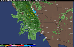

Intellicast.com Composite Radar
May 1, 2009 6:15 p.m. PDT
|
An unseasonably strong, late season Pacific storm system brought rain to much of California Friday and Saturday, including some areas of Southern California.
Los Angeles basin and valley areas generally recorded a trace of precipitation, but some stations in the Ventura mountains recorded as much as 0.3 inch. Here is an archived copy of a NWS Public Information Statement, with some precipitation totals from around the area.
Heavier rain occurred in Central California. A new rainfall record for May 1 was set in Sacramento, and higher elevations of the Sierra received about a foot of snow. Enhanced southwesterly, sub-tropical flow, and enhanced convection associated with the phase 7 MJO may have contributed to the strength of the system.
|
|
SSTs have warmed in the equatorial Pacific, and at least for the moment, orbits of the GWO have shifted to a more ENSO neutral stance. Some longer term ENSO forecasts are now predicting warm ENSO conditions to develop by next Winter.
A warming trend is expected in Southern California over the next several days, with high temperatures in the valleys near 90 by mid-week.
More information concerning Southern California weather can be found using our WEATHER LINKS page.
|