
Cut-off Upper Level Low
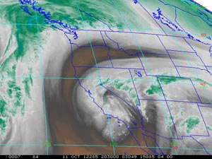
GOES-15 Water Vapor Image - 1:30 p.m. Thursday.
Instability associated with a cut-off upper level low resulted in scattered strong thunderstorms and widespread showers in Southern California on Thursday. A GOES Sounding 8 nm NW of KLAX at 3:00 pm indicated an LI of -4 and CAPE of 836.
According to NWS Storm Reports a spotter in Simi Valley area near Tapo St. and the 118 Frwy reported 1.0 inch of rain in 15 minutes and 1.5 inches in 30 minutes with street flooding. A Mesonet station in Simi Valley recorded 0.84 inches of rain in 12 minutes. A Mesonet station near Pasadena recorded 1.1 inches in 25 minutes. Long Beach Airport set a new rainfall record for the date of 0.30 inches.
The rain gauge at Downtown Los Angeles (USC) dodged all but a few rain drops, recording 0.01 inch for the storm. Here's an archived copy of a NWS compilation of preliminary rainfall totals across the area.
More information about Southern California weather and climate can be found using our WEATHER LINKS page.