
Aqua-MODIS Composite Satellite Image (NRL)
Saturday, June 4, 2011
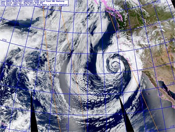
An unseasonably strong Pacific low pressure system that stalled about 200 NM off the Central Californio coast set new rainfall records from San Francisco to Santa Barbara over the weekend. The N-S oriented front associated with the system was positioned over Santa Barbara and San Luis Obispo counties much of the weekend, resulting in unusually high rainfall totals in some areas. Midday Sunday the upper low began to move east along 35°N, increasing divergence aloft in areas north of Pt. Conception and producing additional precipitation Sunday afternoon and evening.
Saturday a new rainfall record for the date was set in San Francisco; and on Saturday and Sunday new rainfall records were set in Stockton, Modesto, Paso Robles and Santa Maria. Sunday Santa Barbara Airport recorded 1.24 inches of rain, breaking the record for the date, and increasing the station's rainfall total for June to the highest since recordkeeping began in 1941. The dissipating front produced some scattered showers in the Los Angeles area Sunday.
There were some impressive storm totals. Nordhoff Ridge, in Ventura County, recorded 1.07 inches of rain; Refugio Pass, in Santa Barbara County, 2.64 inches; and Rocky Butte, in San Luis Obispo County, 3.94 inches. Downtown Los Angeles (USC) recorded a trace of rain on Sunday, leaving our water year (July 1 to June 30) rainfall total at 20.19 inches. Here is an archived copy of a NWS Los Angeles/Oxnard compilation of some rainfall totals from around the area.
Saturday I did a trail run on the 8000-9000 ft. ridge between Mt. Pinos and Mt. Abel, north of Los Angeles, and was able to observe first-hand the very strong southerly flow associated with this system, and the spectacular wave clouds that resulted.
More information about Southern California weather and climate can be found using our WEATHER LINKS page.