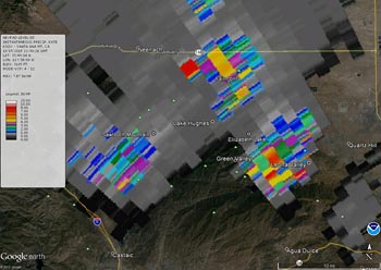

NEXRAD LEVEL-III Radar Instantaneous Precipitation Rate
Lake Hughes - Elizabeth Lake Area at 3:30 pm October 15, 2015 (KSOX)
Following a circuit through Arizona, Mexico and the Eastern Pacific that started in Southern California on October 5, a moisture-laden upper low moved into SoCal for a second time Thursday, October 15.
On the second go-round the upper low packed an even bigger punch, producing strong afternoon thunderstorms with very high rain rates that resulted in severe flash flooding and debris flows in northern Los Angeles County and southern Kern County.
CIMSS Morphed Integrated Microwave Total Precipitable Water Imagery from October 12 shows the upper low entraining moisture from the sub-tropics and tropics as it retrograded into the Eastern Pacific.
Below are some NEXRAD Level-III/Google Earth composites of northern Los Angeles County and southern Kern County for the afternoon of October 15:
Overview
- PPS Storm Total Precipitation for the period ending 6:00 pm PDT. (KSOX)
- QPE Storm Total Precipitation for the period ending 6:00 pm PDT. (KSOX)
- PPS Storm Total Precipitation for the period ending 6:00 pm PDT. (KEYX)
- QPE Storm Total Precipitation for the period ending 6:00 pm PDT. (KEYX)
Lake Hughes - Elizabeth Lake Area
- One Hour Precipitation ending 3:30 pm PDT. (KSOX)
- Instantaneous Precipitation Rate at 3:20 pm PDT. (KSOX)
- Instantaneous Precipitation Rate at 3:30 pm PDT. (KSOX)
Leona Valley
- One Hour Precipitation ending 4:42 pm PDT. (KSOX)
- Instantaneous Precipitation Rate at 4:25 pm PDT. (KSOX)
Hwy 58 - Cameron
- One Hour Precipitation ending 5:39 pm PDT. (KEYX)
- Instantaneous Precipitation Rate at 5:21 pm PDT. (KEYX)
- Instantaneous Precipitation Rate at 5:30 pm PDT. (KEYX)
Here are NWS tabulations of some rainfall totals around the area for October 15 and some totals for October 16.
More information about Southern California weather and climate can be found using our WEATHER LINKS page.