
HPC 5-Day Precipitation Forecast
For the 5 Day Period Ending December 22, 2010 at 4:00 a.m.
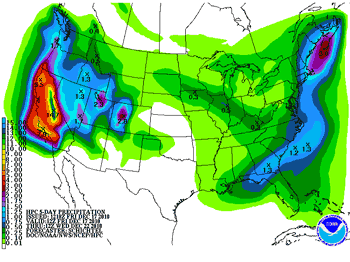
If current precipitation forecasts and outlooks validate, December 2010 could become one of the wettest on record in California, and at the higher elevations of the Sierra, one of the most snowy. This morning's 5-day precipitation forecast from the Hydrometeorological Prediction Center, for the 5-day period ending early Wednesday morning, indicates up to 7.9 inches of precipitation locally, and 14.7 inches (water equivalent) in the Sierra. And additional precipitation is forecast beyond the 5 day period.
A large Pacific low working in concert with a low west of Hawaii has established a tropical connection, and is pumping copious amounts of moisture into California. This tropical moisture conveyor belt scenario is currently forecast to continue into next week. Late Sunday, shortwave impulses dig down into the low and elongate it southwestward, creating a large longwave trough. This northern part of this trough is forecast to evolve into another large upper and surface low in the northeastern Pacific. The southern part of the trough is forecast to develop a surface low and front that moves into Southern California Tuesday into Wednesday.
In the short term, BUFKIT analysis of WRF ensemble data for Van Nuys shows precipitation totals through early Sunday morning ranging from about 1.0 inch up to about 3.5 inches. Analysis of 12z NAM data for Van Nuys produces around 1.8 inches through early Sunday morning and nearly 5 inches through early Monday morning. The 09z SREF pegs the probability of more than 1.0 inch of precipitation in Los Angeles area at around 70%. Precipitable water values of over 1.0 inch, high relative humidity, and a strong south to southwesterly inflow of over 30 knots should produce significantly enhanced precipitation on favored slopes -- generally those with a south to southwest aspect.
It's a little early to put much credence in forecasts for next week, other than more rain appears likely. The 06z GFS produced astronomic precipitation totals mid-week -- several inches more than either yesterday afternoon's 00z run (2.75 inches), or this morning's 12z run (4.6 inches). We'll see!
As of yesterday Downtown Los Angeles (USC) rainfall was 0.91 inch below normal for the water year, and much of Southern California was falling behind in the rainfall department. It looks like by next week we'll be ahead of the La Nina game again, perhaps way ahead.
More information concerning Southern California weather can be found using our WEATHER LINKS page.