
Experimental PSD Precipitation Forecast Guidance
Issued November 19, 2013.
Prepared by Klaus Wolter, CIRES & NOAA-ESRL PSD
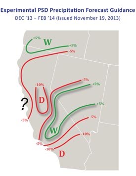
An experimental PSD forecast issued November 19, 2013 for the period December 2013 through February 2014 prepared for the California DWR by Dr. Klaus Wolter of the Cooperative Institute for Research in Environmental Sciences at the University of Colorado shows a significantly increased chance of less than normal precipitation in most of Southern California and the Central San Joaquin Valley. The forecast guidance shows the shift in tercile probabilities for precipitation, similar in concept to the NOAA CPC precipitation outlooks.
According to Dr. Wolter the statistical forecast scheme integrates as many of the known influences on California's climate as possible, using data from 1950 onwards. In the absence of El Nino and La Nina influences considerations such as the status of the Pacific Decadal Oscillation (PDO), the Atlantic Multidecadal Oscillation (AMO), or recent Alaskan temperatures can be evaluated through statistical models to make a forecast.
Dr. Wolter also produced composite precipitation anomalies for the periods October-December and January-March for years with comparable PD0-AMO indices. In Southern California the Oct-Dec anomalies were -0.5 to -0.7 SD below the 1895-2000 Longterm Average and the Jan-Mar anomalies were -0.1 to -0.3 SD below average.
Since October 1 precipitation in California, Oregon and Washington has generally been well below normal. As of today the precipitation recorded at Downtown Los Angeles is at about 30% of normal for the water year (July 1-June30). If Los Angeles doesn't record more than 0.58 inch of rain over the remainder of December, 2013 will rank as the driest calendar year on record.
A wildcard in the California precipitation outlook is the occurrence of atmospheric rivers such as those that occurred at the end of November 2012 and during December 2010. An analysis of all winter ARs in California during WY1998–2011 presented in the paper The 2010/2011 snow season in California's Sierra Nevada: Role of atmospheric rivers and modes of large-scale variability by Bin Guan, et.al., found that atmospheric river frequency is increased during negative phases of the Arctic Oscillation (AO) and the Pacific-North American (PNA) teleconnection patterns.
More information about Southern California weather and climate can be found using our WEATHER LINKS page.