|
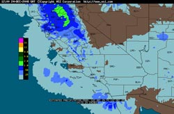

Intellicast.com Radar Precipitation Estimate
24 hrs. Ending 4:00 am 12/25/08
|
A Pacific storm system -- which at one point was expected to be the wettest of the rain season thus far -- took a more westward track and skirted the coast of Southern California on Christmas Eve, generally producing only modest rainfall across the area.
Today, the trough digging down the coast is further west that forecast. (In retrospect this might have been foreseen taking into account the GWO phase 1-2 transition.) In any case, the flow into California has been moist and cyclonic, and rain has continued in many areas, with snow at the higher elevations.
|
|
A front associated with this trough is working its way down the coast, and early this afternoon is just north of Los Angeles. This could add a little more to our rainfall totals as it moves through later today. We'll see!
Update 12/26/08 10:30 am. Here are some preliminary storm totals from the NWS Los Angeles/Oxnard and storm totals from the NWS San Diego.
More information concerning Southern California weather can be found using our WEATHER LINKS page.
|