|
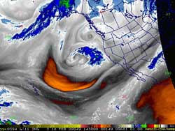

RAMDIS IR3 Water Vapor Image
February 18, 2009 6:30 a.m. PST
|
Downtown Los Angeles (USC) recorded 1.40 inch of rain in our latest storm, bringing the water year total to 9.37 inches, which is only 0.8 inches below normal for the date. Rainfall totals generally ranged from 1.0 to 2.0 inches in the basin and valleys, with somewhat higher amounts recorded in favored foothill and mountain locations. There was heavy snow in the mountains. Here is an archived copy of a NWS Public Information Statement listing some rain and snowfall totals for the storm.
A large cut-off low pressure complex currently at about 140°W is forecast to spin tauntingly off the coast through Friday or Saturday. Pinwheeling low and vorticity centers, a building ridge, a 150 kt. jet, tropical moisture, and an upstream shortwave are in the forecast mix. At this point it looks like some form of the system moves onshore on Sunday, with most of the rain occurring north of Pt. Conception. However, the situation is extraordinarily complex, and we'll have to see how the forecast evolves.
|