
NOTES ABOUT SOUTHERN CALIFORNIA WEATHER & CLIMATE
© 2000-2024 Gary Valle'. All Rights Reserved.
|
NOTES ABOUT SOUTHERN CALIFORNIA WEATHER & CLIMATE © 2000-2024 Gary Valle'. All Rights Reserved. |
IMPORTANT!! The
information presented on this web site may include errors of transcription,
interpretation, and other errors. The information may be out of date or
inaccurate. Please refer to the NATIONAL WEATHER SERVICE FORECAST OFFICE
LOS ANGELES or your local weather service office for official
forecasts and warnings. |
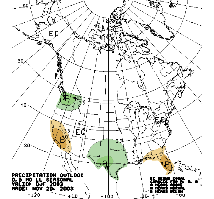 CPC Precipitation Outlook Dec-Jan-Feb Issued 11/20/03 |
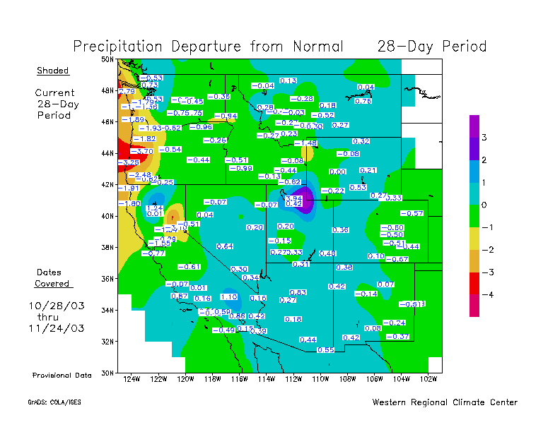
Weathernotes for Wednesday, November 26, 2003The long lead seasonal precipitation forecast issued November 20, 2003 for Dec-Jan-Feb indicates a precipitation probability anomaly of 40% below normal over a large area of Southern and Central California. In the context of this forecast, this equates to a 73.3% probability of below normal, 23.3% probability of normal, and only a 3.3% probability of above normal precipitation in the area depicted. |
|
However, note that this forecast has marginal skill in forecasting precipitation. According to the CPC:
So far this rainy season has appeared to follow a more or less normal course with average to above average precipitation over the last 28 days in most of California. The current 6 to 10 day outlook, and 8 to 14 day outlook, forecast above average precipitation for Southern California. We'll see! More information concerning Southern California weather can be found using our WEATHER LINKS page. |
|
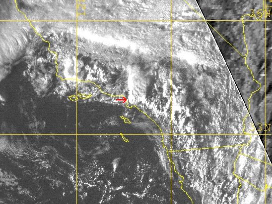 NRL Visible Satellite Photo 11/13/03 0000z (11/12 4:00 pm PST) |
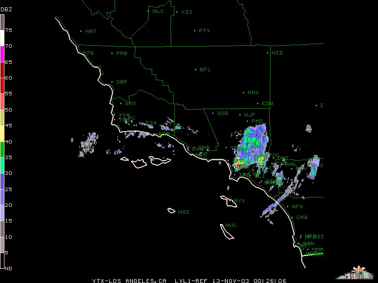
Weathernotes for Thursday, November 13, 2003Over five inches of rainfall was recorded by a rain gauge at 96th and Central yesterday afternoon in southern Los Angeles, resulting in flooded streets, stalled cars and other rainfall related problems. The heavy rain and hail was produced from a virtually stationary thunderstorm cell that started developing a few minutes after 3:00 pm and did not dissipate until after 6:00 pm. |
|
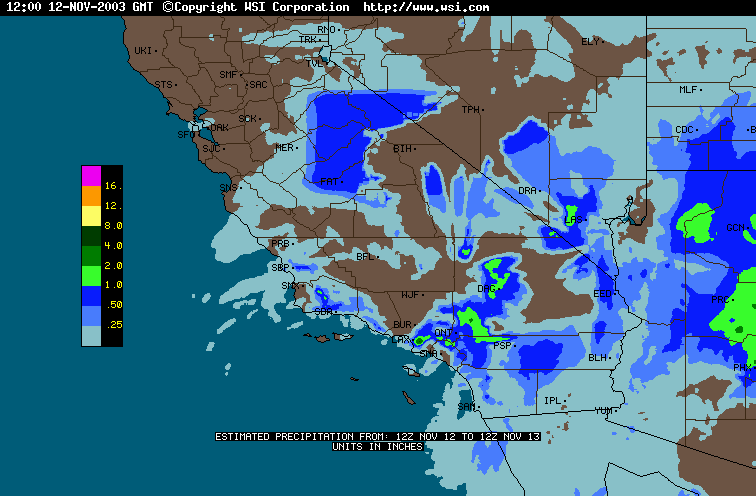
The red arrow added to this visible satellite photo from the Naval Research Laboratory indicated the location of the thunderstorm cell at 4:00 pm yesterday. A composite radar image from the NCAR/RAP's NEXRAD Data Archives shows the same cell. An WSI Intellicast 24hr precipitation estimate for yesterday indicates how much precipitation amounts varied throughout the area, as well as how little the cell over southern Los Angeles moved. The upper level low that produced yesterday's thunderstorms has moved into Nevada, but a few isolated residual showers could occur in some areas of Southern California this morning. The GFS computer model continues to forecast another bout of wet weather for Southern California in the latter half of next week. The current 6 to 10 day, and 8 to 14 day forecasts list above normal precipitation for Southern California. We'll see! More information concerning Southern California weather can be found using our WEATHER LINKS page. |
|
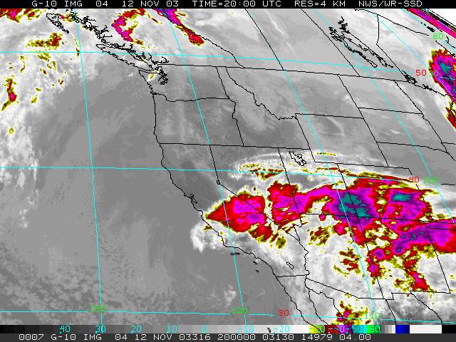 GOES-10 IR 11/12/03 2000z (12:00 pm PST) |
Weathernotes for Wednesday, November 12, 2003Upper level low with 500mb temps of -23 deg. C is destabilizing the air mass over Southern California as well as circulating "wrap around" moisture into the region. Due to the convective nature of the precipitation, rainfall amounts vary widely, with the heaviest amounts through mid-day generally south and east of the basin. |
|
Six hour rainfall totals, as of 12:30 pm, generally range from 0.25 to 0.75 inch, with over an inch recorded in some mountain and desert locations. Some recorded amounts: Julian 0.67", Palomar Mountain 0.56", Ranchita 1.10", Upper Snow Creek 0.88, Ontario 0.04, LAX 0.00. The upper level low is currently forecast to move into Nevada by mid-day tomorrow, with the threat of precipitation ending in most areas of Southern California by tomorrow evening. At the moment, a trough that is forecast to affect Northern California in the Friday into Saturday timeframe is not expected to produce measurable precipitation in our area. The GFS computer model has been consistently forecasting another bout of wet weather for Southern California in the latter half of next week. The current 6 to 10 day, and 8 to 14 day forecasts list above normal precipitation for Southern California. We'll see! More information concerning Southern California weather can be found using our WEATHER LINKS page. |
|
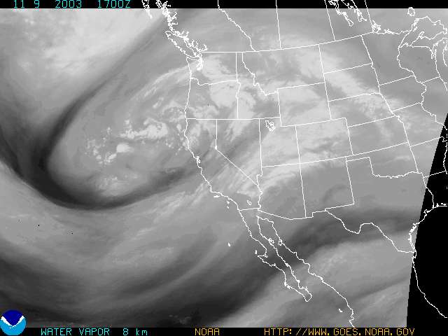 GOES-10 Water Vapor 11/09/03 1700z (9:00 am PST) |
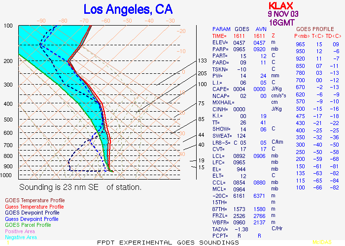
Weathernotes for Sunday, November 9, 2003Southwesterly flow over Southern California associated with upper level low off the Northern California coast is lacking in lifting mechanisms and low level moisture, and is producing little in the way of precipitation in the Los Angeles basin. A GOES sounding for LAX for 16z is considerably drier than forecast by the AVN. |
|
To the north of the basin the atmosphere was more moist and there was better dynamics, resulting in more precipitation; particularly on southwest and southerly facing foothill and mountain slopes. In the Santa Barbara area San Marcos Pass, La Cumbre Peak and Figuero Mountain all recorded about 1.25" of rain. The upper level low is currently forecast to drop down the coast and retrograde to the west somewhat, resulting in partly cloudy skies with a chance of showers Tuesday into Wednesday. Drier, warmer weather is expected by the week's end. The current 6 to 10 day, and 8 to 14 day forecasts for Southern California are for below normal to above normal temperatures and below normal precipitation. More information concerning Southern California weather can be found using our WEATHER LINKS page. |
|
