
NOTES ABOUT SOUTHERN CALIFORNIA WEATHER & CLIMATE
© 2000-2024 Gary Valle'. All Rights Reserved.
|
NOTES ABOUT SOUTHERN CALIFORNIA WEATHER & CLIMATE © 2000-2024 Gary Valle'. All Rights Reserved. |
IMPORTANT!! The
information presented on this web site may include errors of transcription,
interpretation, and other errors. The information may be out of date or
inaccurate. Please refer to the NATIONAL WEATHER SERVICE FORECAST OFFICE
LOS ANGELES or your local weather service office for official
forecasts and warnings. |
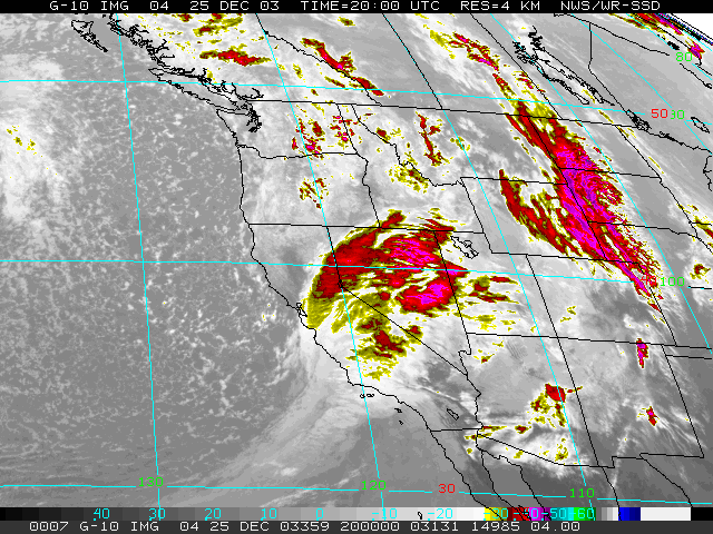 GOES-10 IR Satellite 12/25/03 2000z (12:00 pm Christmas) |
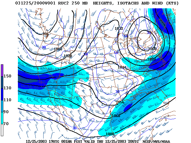
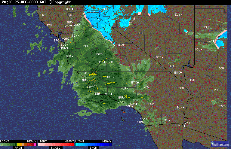
Weathernotes for Friday, December 26, 2003A complex weather system moved through Central and Southern California Christmas Eve and Day, resulting in very heavy Sierra snow, and rain over much of the Southland. The highest rainfall amounts generally occurred in orographically favored foothill and mountain areas. OPHIDS Camp recorded 4.96 inches and the Lytle Creek RAWS recorded over 8 inches of precipitation. A large debris flow occurred in Waterman Canyon in the San Bernardino mountains, tragically overrunning a youth camp. |
|
Over Christmas Eve there was abundant moisture, but little in the way of dynamics. Isentropic lifting resulted in a persistent light rain over the lowlands, and this was orographically enhanced in many foothill and mountain areas. Christmas Day a jet max enhanced rainfall as the front and low progressed through the area. Rainfall at lower elevations generally ranged from about 0.5 inch to 2 inches for the storm. Downtown Los Angeles (USC) recorded about an inch of rain. As of 2:00 pm today, Los Angeles (USC) is 0.67 inch below normal precipitation for the water year. Another strong storm is currently forecast to move into Central and Southern California Sunday or Monday. The GFS continues the active weather pattern well into the New Year. The current 6 to 10 day precipitation outlook for Southern California continues to be above normal, while the 8 to 14 day outlook is normal. More information concerning Southern California weather can be found using our WEATHER LINKS page. |
|
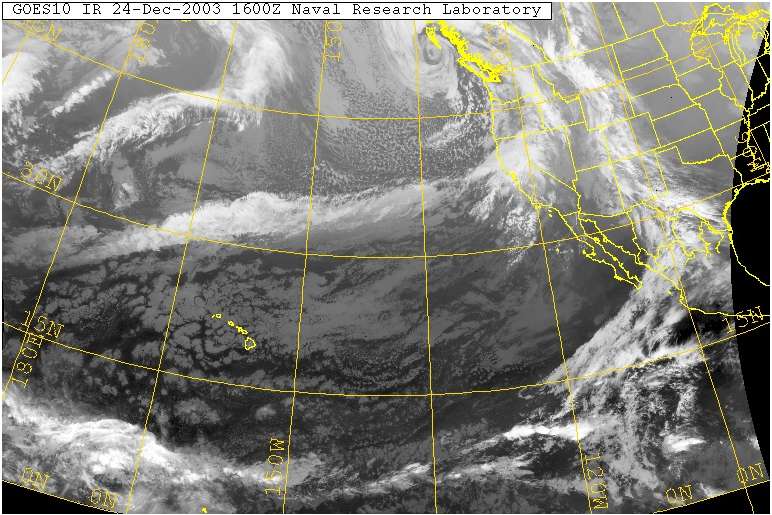 GOES-10 IR Satellite 12/24/03 1600z (8:00 am Wednesday) |
Weathernotes for Wednesday, December 24, 2003Yesterday's caution regarding the computer models was well founded. Models have turned back to somewhat wetter solutions. For what it's worth the ETA seems to be settling on about 0.8 to 1.0 inch of rain at Los Angeles over a 24 hour period beginning this evening around 10:00 pm, while the GFS generates only about 0.5 inch over a 15 hour period beginning early Christmas morning. Higher amounts would be expected in orographically favored foothill and mountain areas. |
|
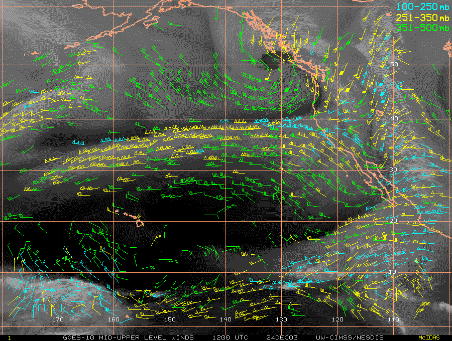
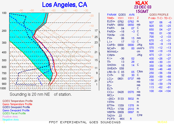
Whatever the models say, satellite photos show a long, energetic fetch of moisture and its associated 150 kt jet taking aim on California. This fetch is expected to say southward, with a jet max and its associated dynamics enhancing precipitation rates as it moves over the coast. The difficult question for the models and forecasters is, "How far south?" In addition when there is a long fetch and strong jet, it is not uncommon for a wave to develop with possible cyclogenesis. We'll just have to see what Santa brings! Rainfall yesterday did not live up to revised expectations. This was due in part to model inconsistencies, but also the fact that lower levels of the atmosphere over Southern California were dry. This GOES-10 sounding from yesterday morning at LAX shows the atmosphere was dry up to nearly the 550 mb level. Recorded precipitation yesterday ranged from over an inch at orographically favored La Cumbre Peak in Santa Barbara, to about a 0.10 inch around the Los Angeles basin. The weather pattern looks like it will remain active through the end of 2003, so there's likely to be more wet weather after Christmas and before the New Year. The current 6 to 10 day and 8 to 14 day outlooks continue to forecast above average precipitation for Southern California. More information concerning Southern California weather can be found using our WEATHER LINKS page. |
|
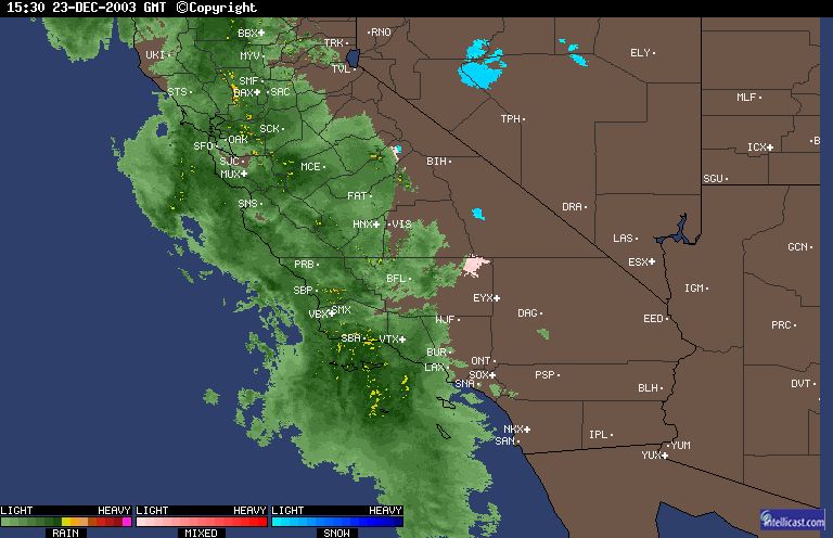 WSI Intellicast Radar 12/23/03 15:30z (7:30 am Tuesday) |
Weathernotes for Tuesday, December 23, 2003This Intellicast radar composite from 7:30 this morning looks wet! A system that was expected to produce perhaps 0.10 inch of rain in the Los Angeles basin, has tapped into moisture associated with an active weather area in the tropics, discovered some dynamics, and developed into a wetter and stronger system. |
|
Rain gauges along the central coast and as far south as Santa Barbara have generally recorded between 0.04 and 0.16 inch this morning with some higher amounts near San Simeon; and there's already some light rain in the Los Angeles area. Twenty-four hour QPF forecasts from the NWS, HPC and the CNRFC suggest rainfall totals of about 0.75 to 1.0 inch of rain along the central coast, 0.5 to 0.75 inch in Ventura and Santa Barbara, and about 0.25 to 0.5 inch in the Los Angeles area. Some locally higher amounts are possible, especially in foothill and mountain areas. In another dramatic turnaround, recent runs of the computer weather models are not nearly as wet with the system forecast for Christmas Eve and Day! The GFS from 12z today generates only 0.1 inch rain, and most of that is overnight on Christmas Eve. In these recent runs the jet max is positioned further to the north, and there is little in the way of moisture and dynamics. With such a dramatic change in the model's forecast some caution is in order, but drier weather would be good news for all of us anxious to get outside and play on Christmas Day! We'll see! The weather pattern looks like it will remain active through the end of 2003, so there's likely to be more wet weather before the New Year. The current 6 to 10 day and 8 to 14 day outlooks continue to forecast above average precipitation for Southern California. More information concerning Southern California weather can be found using our WEATHER LINKS page. |
|
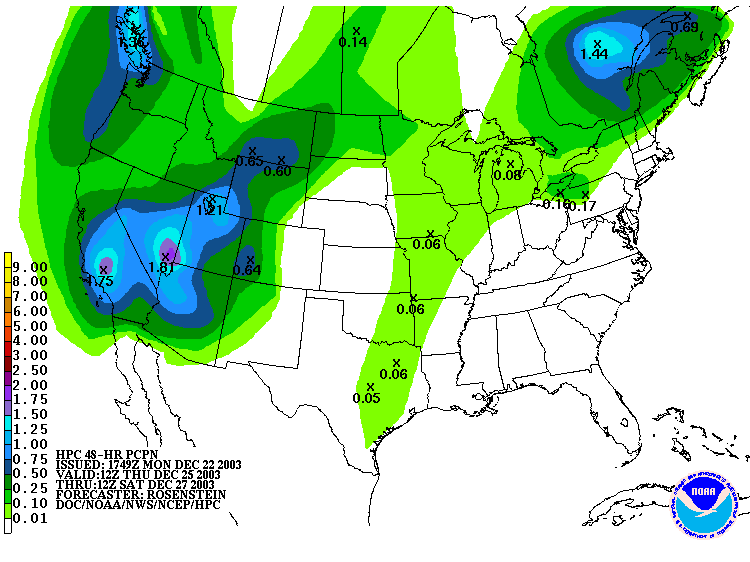 HPC Day 4-5 Precipitation Forecast Issued 122203 1749z |
Weathernotes for Monday, December 22, 2003It's been some time since Southern California has received a widespread soaking from a Pacific storm. As of yesterday, downtown Los Angeles (USC) rainfall was 1.39 inches below normal for the date. However most of this deficit may be erased by a storm forecast to move into the area Christmas day, and another system computer models predict may affect the area near the year's end. |
|
At the moment, the HPC Quantitative Precipitation Forecast for the 48 hour period from 4:00 am Christmas to 4:00 am Saturday shows a widespread area of more than and inch of precipitation. The GFS from 12z today generates about an inch of rain over a 24 hour period starting Christmas morning. Favorable positioning of a jet max and strong 25-45 kt southwesterly inflow could result in higher rain and snowfall totals, particularly in the foothills and mountains. As the storm moves through temperatures and the snow level are forecast to drop significantly, with overnight temperatures Friday and Saturday possibly into the thirties away from the coast. We'll see! The current 6 to 10 day and 8 to 14 day outlooks continue to forecast above average precipitation for Southern California. More information concerning Southern California weather can be found using our WEATHER LINKS page. |
|
