
NOTES ABOUT SOUTHERN CALIFORNIA WEATHER & CLIMATE
© 2000-2024 Gary Valle'. All Rights Reserved.
|
NOTES ABOUT SOUTHERN CALIFORNIA WEATHER & CLIMATE © 2000-2024 Gary Valle'. All Rights Reserved. |
IMPORTANT!! The
information presented on this web site may include errors of transcription,
interpretation, and other errors. The information may be out of date or
inaccurate. Please refer to the NATIONAL WEATHER SERVICE FORECAST OFFICE
LOS ANGELES or your local weather service office for official
forecasts and warnings. |
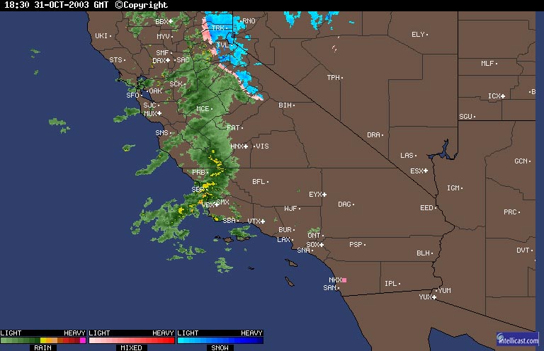 Intellicast Radar - 10/31/03 1830z (10:30 am) |
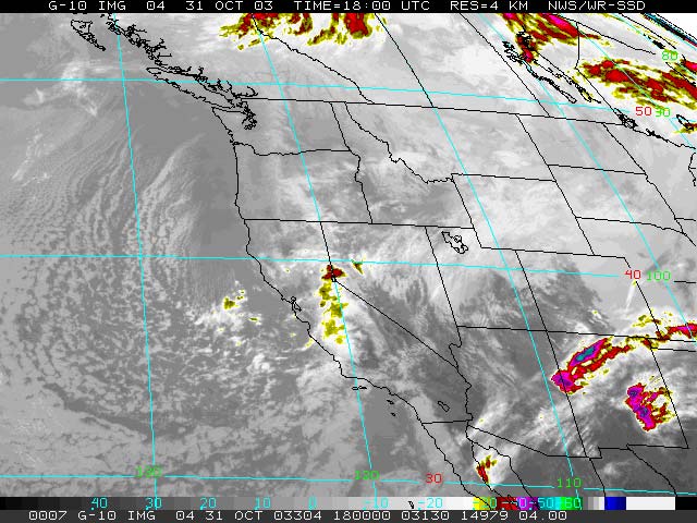
Weathernotes for Friday, October 31, 2003The first significant wet weather of the 2003-2004 rainy season is bad news for trick-or-treaters but good news for homeowners and firefighters battling the wildland fires across Southern California. An Intellicast radar graphic and a GOES-10 IR satellite image show the location of the precipitation band at about 10:30 this morning.
|
|
QPF forecasts for the Los Angeles basin suggest about 0.3 to 0.5 inch of rain in coastal and valley locations with more in orographically favored foothill and mountain locations. Lightning has been observed in the frontal band, so there is a possibility of thunderstorms. Less precipitation is expected south of the basin. Cool, unsettled weather is expected to continue through mid-week. At the moment Sunday looks dry, but computer models suggest there is another chance for some rain Monday afternoon into Tuesday. The current 6 to 10 day, and 8 to 14 day forecasts for Southern California are for below normal temperatures and normal to below normal precipitation. More information concerning Southern California weather can be found using our WEATHER LINKS page. |
|
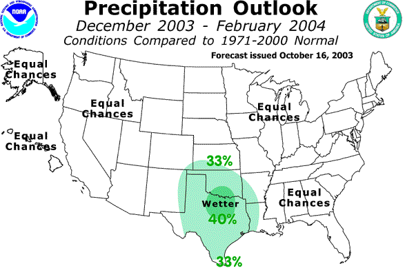 NOAA Winter Precipitation Outlook ( Issued 10/16/03) |
Weathernotes for Tuesday, October 21, 2003NOAA has released its 2003-2004 Winter Outlook for the U.S. The forecast is very similar to that issued in September, with equal chances for below average, normal, or above average precipitation for the West and much of the country.
|
|
When the El Niño/Southern Oscillation (ENSO) state is neither warm (El Niño) or cold (La Nina) forecasting tools have little skill at predicting longer term precipitation trends in the West. The typical Winter pattern when the ENSO state is neutral generally positions the Pacific Jet Stream to our north and the Subtropical Jet Stream to our south. Neither dominates, and the amount of precipitation becomes dependent on shorter term factors and patterns. One, somewhat unexpected, wrinkle has emerged. After looking like a La Nina would develop, and then returning to near neutral for several months, equatorial waters have warmed to just below the threshold that defines a weak El Niño. According to NOAA scientists a weak El Niño is possible by the end of November, but they "expect a minimal impact on the United States. " While areas of the Northwest are being deluged by rainfall, our weather will continue to be dominated by a high pressure ridge and hot weather. The current 6 to 10 day, and 8 to 14 day forecasts for both Southern and Northern California are for normal to above average temperatures and below average precipitation. More information concerning Southern California weather can be found using our WEATHER LINKS page. |
|
