
NOTES ABOUT SOUTHERN CALIFORNIA WEATHER & CLIMATE
© 2000-2024 Gary Valle'. All Rights Reserved.
|
NOTES ABOUT SOUTHERN CALIFORNIA WEATHER & CLIMATE © 2000-2024 Gary Valle'. All Rights Reserved. |
IMPORTANT!! The
information presented on this web site may include errors of transcription,
interpretation, and other errors. The information may be out of date or
inaccurate. Please refer to the NATIONAL WEATHER SERVICE FORECAST OFFICE
LOS ANGELES or your local weather service office for official
forecasts and warnings. |
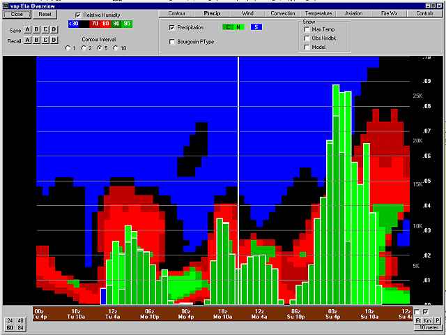 BUFKIT computation of QPF based on the 01/27/02 00z ETA |
Weathernotes for Monday, January 28, 2002Sometimes the magic of computer weather models works, but other guidance suggests the model be discounted. None of the mainstream Quantitative Precipitation Forecasts for yesterday specified more than a tenth of an inch of rain for the Los Angeles area. It appeared to forecasters that there would not be adequate dynamics to produce significant rain. This is basically what the AVN model depicted. |
|
Yesterday morning a BUFKIT computation of QPF based on the 01/27/02 00z ETA forecast a total 0.655 inch of rain for Sunday. At the time, it appeared this forecast was very improbable. Wrong! This was about the amount of rainfall Valley locations received. For the 24 hour period ending 7:00 this morning, Sepulveda Dam recorded 0.54, Chatsworth 0.63, and L.A. 96th & Central 0.67 inch. Several orographically favored mountain and foothill stations recorded more than 2.0 inches. For example; Big Tujunga Dam 2.24, West Fork Heliport 2.32, and Cogswell Dam 2.56 inches. OPIDS Camp recorded 3.17 inches. Los Angeles (USC) recorded 0.62 inch. The broad, cold upper level trough is resulting in cooler temperatures and a chance of showers today, with a continued chance of showers through Tuesday afternoon and cold overnight lows. Today's CPC/NCEP Outlooks depicted "Normal" precipitation for the 6-10 day period and "Normal" for the 8-14 day period for Southern California. More information concerning Southern California weather can be found using our WEATHER LINKS page. |
|
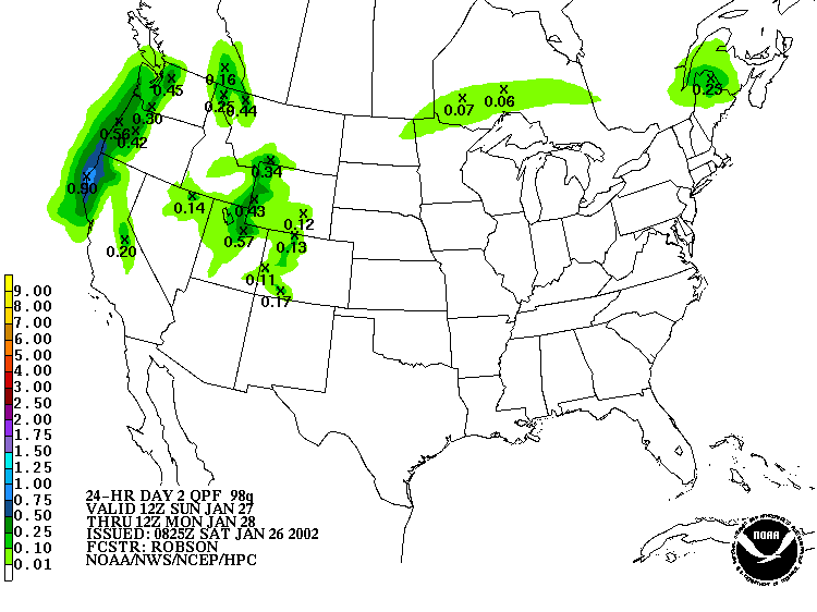 HPC QPF for 24 Hours Ending 01/28/02 |
Weathernotes for Saturday, January 26, 2002Sometimes the magic of computer weather models works, sometimes it doesn't. Yesterday it looked like we would get some significant rain on Sunday, but the trough has been slow to dig southward and the system's dynamics and moisture are out of synch. The 0825z HPC precipitation forecast for Sunday reflects these changes with no measurable rain depicted in the Southland. |
|
However, 12z model cross-sections show ample atmospheric moisture in the area tomorrow (Sunday) morning. Any lifting mechanism could produce drizzle or light rain. A 120 kt jet max is progged to be overhead and depending on its actual strength and position, could contribute to the marginal dynamics and increase the chance of showers. The main action is now forecast to be on Monday when the upper low, and the system's best dynamics, move through the area. We'll see! Yesterday's CPC/NCEP Outlooks depicted "Normal" precipitation for the 6-10 day period and "Below Normal" for the 8-14 day period for Southern California. More information concerning Southern California weather can be found using our WEATHER LINKS page. |
|
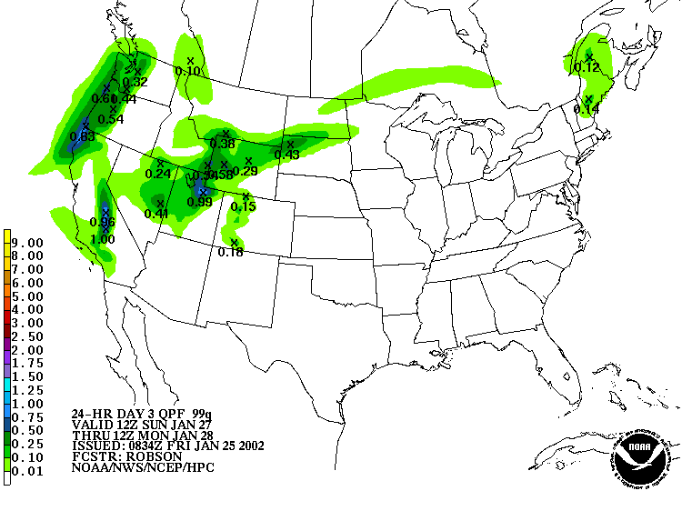 HPC QPF for 24 Hours Ending 01/28/02 |
Weathernotes for Friday, January 25, 2002It's been over 3 weeks since the rain gauge at Los Angeles (USC) has recorded any precipitation. Since July 1, we're more than 3.0 inches below normal. It looks like we may get a little rain Sunday into Monday. Exactly when it will start and how much will fall is difficult to say. |
|
The atmosphere is very dry and it will take some time for it to become saturated. This should occur overnight on Saturday, with rain beginning by noon on Sunday. The current HPC QPF forecast depicts about an inch water equivalent in the Sierra, but only about 0.1 inch of precipitation in the Los Angeles area, with somewhat more in the foothills and mountains. The 12z models suggest that precipitation amounts in the L.A. area could be 0.2 inch or so. We'll see! January has been dry over much of the state. Mammoth Mountain has recorded only 20 inches of snow this month, and most of that was back on January 3rd. Fortunately, the Sierra received above average snowfall through December and the current snowpack remains slightly above normal. Yesterday's CPC/NCEP Outlooks depicted "Normal" precipitation for the 6-10 day period and "Normal" for the 8-14 day period for Southern California. More information concerning Southern California weather can be found using our WEATHER LINKS page. |
|
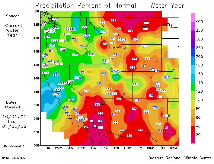 Precipitation for Water Year - Percent of Normal |
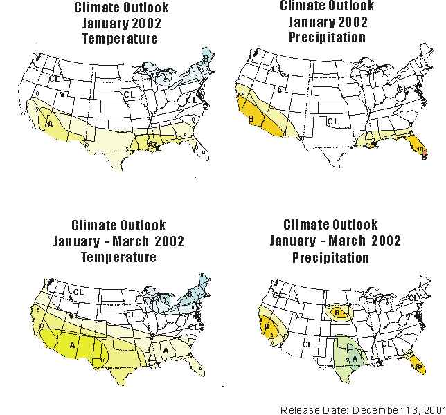
Weathernotes for Monday, January 7, 2002Last week Los Angeles (USC) recorded 0.10 inch of rain on Wednesday, and another 0.02 inch on Thursday. This brought the total rainfall in Los Angeles since July 1 to 2.98 inches, which is 1.34 inches below normal for the date. A plot of the Percent of Normal Precipitation for the Water Year beginning October 1 from the Western Regional Climate Center shows a sharp fall-off in precipitation south of Pt. Conception. |
|
If the December 13th monthly and 3-monthly outlooks from the Climate Prediction Center are any indication, the accumulated precipitation could remain below normal for the remainder of this rainy season. But that's an outlook, not a forecast We'll see what actually happens. In a change from earlier runs and other models, the 12z run of the ETA-12 brings a chance of showers into the area during the day on Wednesday. HPC's current quantitative precip forecast also indicates a chance of a shower on Wednesday. Today's CPC/NCEP Outlooks depicted "Normal" precipitation for the 6-10 day period and "Above Normal" for the 8-14 day period for Southern California. More information concerning Southern California weather can be found using our WEATHER LINKS page. |
|
