
NOTES ABOUT SOUTHERN CALIFORNIA WEATHER & CLIMATE
© 2000-2024 Gary Valle'. All Rights Reserved.
|
NOTES ABOUT SOUTHERN CALIFORNIA WEATHER & CLIMATE © 2000-2024 Gary Valle'. All Rights Reserved. |
IMPORTANT!! The
information presented on this web site may include errors of transcription,
interpretation, and other errors. The information may be out of date or
inaccurate. Please refer to the NATIONAL WEATHER SERVICE FORECAST OFFICE
LOS ANGELES or your local weather service office for official
forecasts and warnings. |
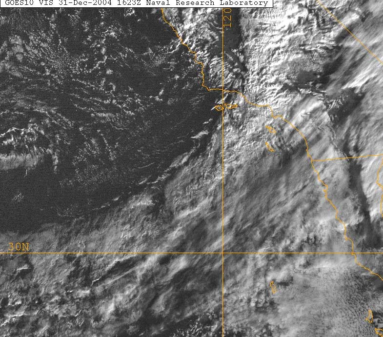 NRL GOES-10 Visible Satellite Photo 12/31/04 16:23z 8:23 am PST |
Weathernotes for Friday, December 31, 2004Frontal zone moving through the Los Angeles basin this morning is producing high rain rates, but should progress through the area more quickly than our last system. Rain rates as high as 0.5 to 0.8 inches per hour have been recorded by several gauges in western Los Angeles county. In the last 24 hours the system has resulted in rainfall totals in Santa Barbara and Ventura counties ranging from about 1.5 inches to over 6.0 inches in some locations. Rainfall totals at several Los Angeles area locations have already exceeded amounts forecast by yesterday's ETA.
|
A generally wet pattern is expected to continue for a least the next several days, with periods of rain as systems move through the area. At the moment, the weather for New Year's Day and the Rose Parade looks to be one of the better days, with a mix of clouds and sun. Those clouds could produce a shower. We'll see! More information concerning Southern California weather can be found using our WEATHER LINKS page. |
|
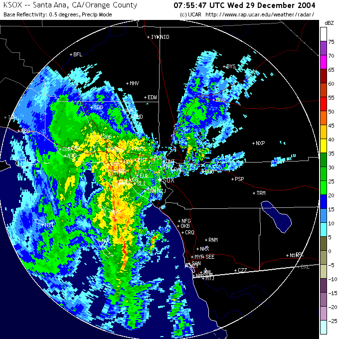 NWS Santa Ana NEXRAD Radar 12/29/04 07:55z (12/28 11:55 pm PST) |
Weathernotes for Wednesday, December 29, 2004NWS NEXRAD radar image from near midnight last night shows complex of strong thunderstorms that resulted in heavy rainfall in downtown Los Angeles (USC) and produced a possible tornado in Inglewood. The NWS reports that downtown Los Angeles received 5.55 inches or rain yesterday, the highest recorded rainfall total for any (calendar) day in December, and the third wettest on record. Burbank, Chatsworth, LAX, Pasadena and several other locations set new rainfall records for the date. |
As of 6:20 this morning rainfall totals from the storm generally range from about 4 to 6 inches with totals exceeding 10 inches at several mountain locations. Upper Matilija Canyon in the Ventura County mountains has recorded 14.69 inches. Rainfall for Los Angeles (USC) is now reported to be 7.71 inches above normal for the water year. Convection in the moist cyclonic flow over the area will likely produce additional showers during the day today. Some showers could be heavy. The outlook for the next several days is for periods of rain A generally wet pattern is expected to continue for a least the next several days, with periods of rain. At the moment, the weather for New Year's Day and the Rose Parade looks to be one of the better days, with a mix of clouds and sun. Those clouds could produce a shower. The 12z 40km ETA produces about one-third of an inch of rain Friday at Los Angeles, with a drying west to northwest flow aloft New Year's Day. We'll see! More information concerning Southern California weather can be found using our WEATHER LINKS page. |
|
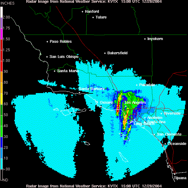
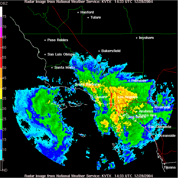 NWS Sulphur Mtn. Composite Radar 12/28/04 14:33z 6:33 am PST |
Weathernotes for Tuesday, December 28, 2004Potent Pacific storm system is progressing pretty much as forecast with more on the way. As of 7:00 a.m. 24 hour rainfall totals in excess of 6 inches have been recorded in the mountains of Santa Barbara and Ventura counties, with as much as 10 inches recorded in some areas. |
This morning a line of strong thunderstorms extending north from near Malibu produced rainfall rates of more than an inch an hour. The Malibu Hills RAWS has recorded more than 4 inches of rain in the last 24 hours. So far, rainfall totals in the Los Angeles area have generally ranged from about 2-3 inches. Additional heavy rain is expected today and tonight. A BUFKIT analysis of 12z ETA data generates an additional 4 inches of rain at Van Nuys from 8:30 this morning to early Thursday morning. On the optimistic side, if recent runs of the GFS verify, the weather for New Year's Day and the Rose Parade might be better than earlier forecasts suggested. Might be... the performance of the GFS hasn't been the best of late and the ECMWF is a bit more pessimistic, suggesting a chance of a shower. At the moment temperatures are not expected to be unusually cold, but if it's damp and breezy it will still feel chilly. We'll see! More information concerning Southern California weather can be found using our WEATHER LINKS page. |
|
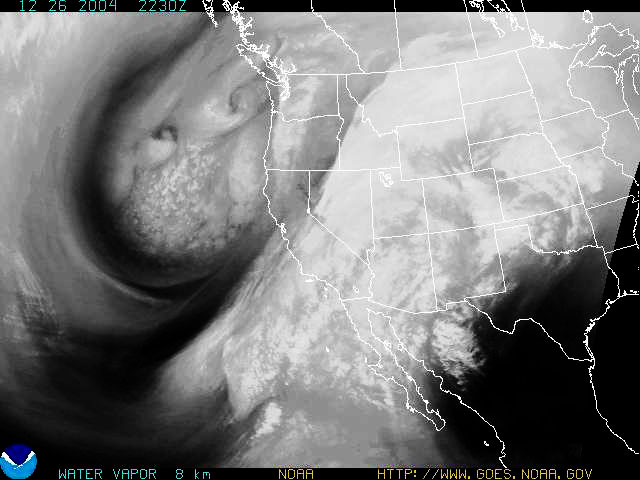 GOES-10 Water Vapor Satellite Photo 12/26/04 22:30z 2:30 pm PST |
Weathernotes for Sunday, December 26, 2004Los Angeles area weather was SPECTACULAR Christmas Day! Keep that sunny, warm, dry weather in mind over the next few days, as a potentially damaging Pacific storm system works its way down the coast, bringing with it the possibility (perhaps likelihood) of heavy rains, strong winds and flooded streets, storm drains, streams and rivers. |
Kudos to the ECMWF model for nailing the significant details of this system more than a week ago—even the influx of sub-tropical moisture from the southwest. The contrast has been increased on this GOES-10 water vapor satellite photo to show the multiple vorticity centers and complex structure of the upper low, as well as the inflow of moisture from the south ahead of the system. Today's weather models continue to forecast very heavy precipitation in Central and Southern California Monday afternoon into Wednesday, particularly in the mountains of Santa Barbara, Ventura and Los Angeles counties. Quantitative precipitation forecasts from the California-Nevada River Forecast Center and the Hydrometeorological Prediction Center indicate more than 9 inches of rain possible in orographically favored areas. Hang on, this could be a big one. What about New Year's Day and weather for the Rose Parade? Still brrrrrr... At the moment the computer weather models are not quite as cold, but are a little wetter than forecast before Christmas. Whatever the exact details, the "feels like" temperatures in Pasadena on New Year's Eve and the morning of January 1st will be chilly, and it could be wet. We'll see! More information concerning Southern California weather can be found using our WEATHER LINKS page. |
|
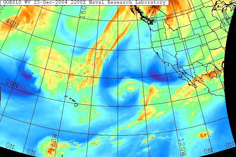 GOES-10 Water Vapor Satellite Photo 12/23/04 22:00z 2:00 pm PST |
Weathernotes for Thursday, December 23, 2004Los Angeles area weather the 11th to the 20th of December flip-flopped, compared to the first ten days, going from cool and wet to dry and warm—almost hot—weather. If computer models verify, cold, wet weather may follow in the wake of Santa's sleigh with the possibility of low elevation snow ushering in the New Year. |
Christmas Day in Southern California should be fair and mild, with diminished winds and warmer daytime temperatures. But Sunday into Monday things begin to change. For the last several runs the ECMWF has been forecasting the development of a relatively strong system off the west coast. Initially much more to the east and drier with the system, the GFS has been trending toward the more westerly and wetter ECMWF solution. A GOES-10 water vapor satellite photo from this afternoon shows ample moisture being transported into the north Pacific. Today's 12z run of the GFS generates about 3.75 inches of rain at Los Angeles from early Sunday to early Wednesday. The longitudinal position of the developing system is one of the factors that could dramatically affect the amount of precipitation in the Los Angeles area. If it tracks more to the west, then the heaviest precipitation might remain offshore. What about New Year's Day and the Rose Parade? Brrrrrr... The New Year is still more than a week away, but unless the models have totally lost it (always a possibility) it looks like temps could be downright cold at the start of the Parade, and there's at least a chance it could be wet. There could even be some snow in the foothills New Year's Eve. The 12z GFS shows 850mb temps of zero all the way to Mexican border the morning of January 1st. We'll see! More information concerning Southern California weather can be found using our WEATHER LINKS page. |
|
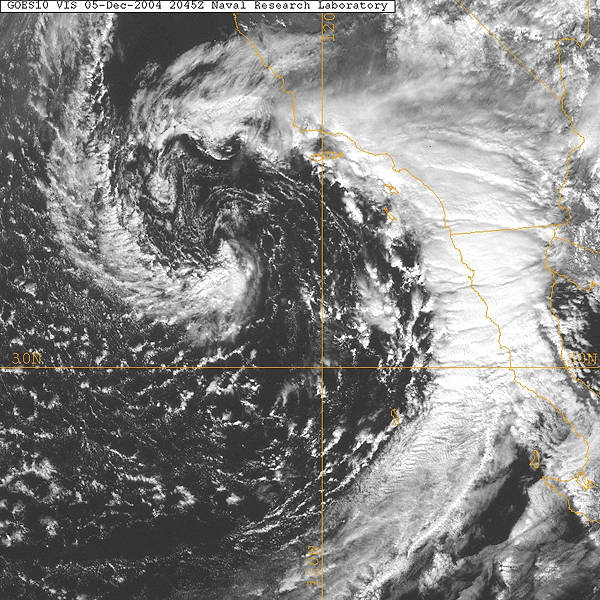 GOES-10 Visible Satellite Photo 12/05/04 20:45z 12:45 pm PST |
Weathernotes for Monday, December 6, 2004Another cold, northern stream upper low and it's associated surface low and front produced generally light to moderate rain from Santa Barbara south to San Diego yesterday. Precipitation amounts ranged from a few hundredths to about a half of an inch. The most significant rainfall appears to have been offshore, with Avalon and Santa Cruz Island recorded about 1.7 inches of precipitation. |
Today into Tuesday another strong system moves onshore in the West, and is forecast to move into the Los Angeles basin Tuesday afternoon. At the moment it appears its primary impact will be on the northern two-thirds of the state, with less precipitation expected south of Pt. Conception. The 12z 40km ETA projects very little precipitation at Los Angeles, but the 12z GFS generates about 0.4 inches. Update 12/8/04 7:00 AM. The GFS outperformed the ETA in estimating the timing of Tuesday 's system, but the precipitation produced by the weakening frontal zone was a median value (more or less) of the model projections. Rainfall amounts, with some exceptions, generally decreased the further south the location from Pt. Conception, with some areas in San Luis Obispo county receiving more than and 1.5 inches of rain. Amounts in the Los Angeles area generally ranged from from a few hundredths to about a 0.4 inch. Following Tuesday evening's system, a building ridge of high pressure should result in fair and warmer weather for a least a few days. We'll see! Temperatures have been on the cool side this Fall. In October and November, preliminary climate data for downtown Los Angeles (USC) indicates the average high temperature was 5 to 6 degrees below normal. More information concerning Southern California weather can be found using our WEATHER LINKS page. |
|
