
NOTES ABOUT SOUTHERN CALIFORNIA WEATHER & CLIMATE
© 2000-2024 Gary Valle'. All Rights Reserved.
|
NOTES ABOUT SOUTHERN CALIFORNIA WEATHER & CLIMATE © 2000-2024 Gary Valle'. All Rights Reserved. |
IMPORTANT!! The
information presented on this web site may include errors of transcription,
interpretation, and other errors. The information may be out of date or
inaccurate. Please refer to the NATIONAL WEATHER SERVICE FORECAST OFFICE
LOS ANGELES or your local weather service office for official
forecasts and warnings. |
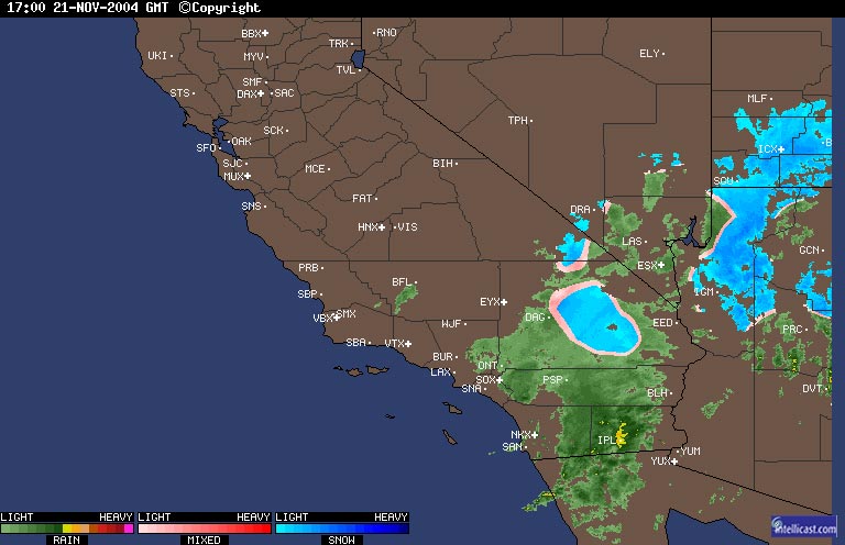 WSI Intellicast.com Composite Radar 11/21/04 17:00z 9:00 am PST |
Weathernotes for Sunday, November 21, 2004Cold, energetic upper low over Southern California has resulted in wind, rain and some lower elevation snow. As of mid-day precipitation amounts have ranged from a few hundredths to about a quarter-inch in basin and valley areas to over an inch in some mountain locations and points south and east of Los Angeles. |
Portions of Highway 138 and Interstate 10 were reported closed this morning, and snow was reported down to as low as 1000 ft. in areas of Riverside and San Bernardino counties Rain and showers are expected to continue east of the Los Angeles basin tonight, with the possibility of some snow at lower elevations. With clearing skies west of the mountains, wind protected areas could see overnight temperatures drop to near freezing. At the moment, computer models and other guidance suggest skies should be mostly clear Thanksgiving Day throughout Southern California, with seasonable temperatures. More information concerning Southern California weather can be found using our WEATHER LINKS page. |
|
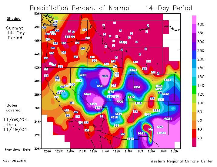 Precipitation Percent of Normal 11/06/04 - 11/19/04 (WRCC) |
Weathernotes for Saturday, November 20, 2004Compared to the record-setting rain and snow in October, November's weather has been much more placid. Month to date, Downtown (USC) has recorded only about 0.02 inches of rain, which is about 0.5 inch below normal for the month.
|
Even so, as a result of October's rain, Downtown's rainfall total remains about 3.1 inches above normal for the water year. The latest Long-lead Precipitation Outlook from the CPC, released Nov. 17, forecasts a slightly better chance of above normal precipitation in Southern California for the remainder of the rainy season (Dec.-Mar.), than for normal or below normal amounts. One of the primary factors in Southern California's precipitation outlook is the continuing, but weak El Nino. Development of the El Nino has stalled in recent months. The Sep/Oct value of the Multivariate ENSO Index (MEI) was 0.538, down somewhat from 0.577 in Aug/Sep, and lower than last year for the same period. The SOI increased from -2.8 in September to -4.0 in October. There is some evidence that October's heavy rains may have been related to the Madden-Julian Oscillation. See Real-time Weather-Climate Discussion and Predictive Insights - 3 November 2004 for additional information. More information concerning Southern California weather can be found using our WEATHER LINKS page. |
|
