
NOTES ABOUT SOUTHERN CALIFORNIA WEATHER & CLIMATE
© 2000-2024 Gary Valle'. All Rights Reserved.
|
NOTES ABOUT SOUTHERN CALIFORNIA WEATHER & CLIMATE © 2000-2024 Gary Valle'. All Rights Reserved. |
IMPORTANT!! The
information presented on this web site may include errors of transcription,
interpretation, and other errors. The information may be out of date or
inaccurate. Please refer to the NATIONAL WEATHER SERVICE FORECAST OFFICE
LOS ANGELES or your local weather service office for official
forecasts and warnings. |
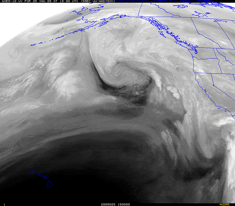 GOES 10 Water Vapor (UW-Madison) 01/25/05 1500z 7:00 am PST |
Weathernotes for Tuesday, January 25, 2005(Any updates will be found at the end of this discussion.) Two weeks of dry, benign weather in Southern California will transition into a 4 day period of unsettled weather. An ARL compilation of 12z 40km North American Mesoscale (formerly ETA, now NAM) model output projects about 2 inches of rain at Los Angeles through Friday afternoon. A complex of upper level lows and a very strong jet extends across the Northern Pacific with moist southerly, sub-tropical flow along the west coast.
|
Computer models show a series of shortwave troughs being ejected from the easternmost upper low, currently near 140W. Two of these waves are expected to interact with the moisture being drawn from the sub-tropics and produce some rainfall in Southern California. With the soil still saturated from our recent heavy rains, any precipitation could be problematic. Based on the 12z NAM, rain associated with the first wave should begin later today or tonight, and extend into Wednesday evening. Then, according to the 12z NAM, precipitation picks up again sometime Thursday morning with the second wave, and continues through Friday. At the moment, the second system appears to have somewhat better dynamics and inflow than the first, and this could result in more rain. Following these systems, another ridge is forecast to build over the West, and several days of dry weather is projected. We'll see! Update 01/27/05 10:00 A.M. Even the reduced amount of precipitation forecast by yesterday's 12z NAM was overstated. Recorded rainfall amounts from Wednesday's system were generally less than 0.1 inch in the Los Angeles area. Models have backed way off on the amount of precipitation forecast for the next system. For Friday, the 12z NAM is projecting only about 0.1 inch of rain at Los Angeles, and the GFS only about 0.2 inch. However, these forecasts might be understated. The front associated with this system is forecast to be a little better defined, and it could produce some heavier rain than seen with yesterday's system, especially if there is development in the southern part of the system not forecast by the computer models. Update 01/26/05 7:00 A.M. This Intellicast.com composite radar image from 6:45 this morning shows showers and rain in many areas of California and the southwest, just not a lot around the Los Angeles area. However, a closer view from NWS Vandenberg radar at 7:38 am and RAMDIS shows multiple bands of precipitation extending from Paso Robles, through Santa Maria and off the coast, with the leading edge over the Channel Islands and moving east, initially into Santa Barbara and Ventura counties. Today's 12z NAM now generates about 0.5 inch of rain at Los Angeles for this first system, and another 0.5 inch from Friday afternoon to early Saturday morning. Update 01/25/05 1:00 P.M. The 18z NAM has backed off somewhat on the amount of precipitation associated with the second system, but increased the precipitation projected for the first to about 1.24 inches at Los Angeles. Overall the 18z NAM generates 1.86 inches at Los Angeles through Friday evening. BUFKIT analysis of 12z NAM data produces about an inch of rain at LAX through early Thursday morning. More information concerning Southern California weather can be found using our WEATHER LINKS page. |
|
 GOES 10 IR Satellite Photo 01/11/05 1630z 8:30 am PST |
Weathernotes for Tuesday, January 11, 2005Upper low responsible for our historic and devastating series of January storms is finally moving south and east and should be well east of our area by tomorrow. Rainfall overnight was less than expected, but the upper low and associated trough could produce additional showers and thunderstorms later today as it moves down the spine of the Sierra into Nevada. Some additional heavy rainfall could occur.
|
Even without additional rainfall, and with the sun shining, dangerous conditions will persist for some time. Many streams have been slow to recede and remain at high levels. Saturated hillsides are capable of producing mudslides and rock fall many days after it stops raining. For additional information see January 2005 California Landslide Information (USGS). According to a NWS Public Information Statement issued this morning, the 15 days from December 27, 2004 through January 10, 2005 were the wettest 15 consecutive days in downtown Los Angeles since record keeping began in 1877. This surpassed the record set in January of 1969. The water year total rainfall to date, since July 1, is the second highest on record, and is about 475% of normal. OPIDS Camp, near Mt. Wilson, has recorded an astounding 31.61 inches since the series of storms began the afternoon of January 6th. The following links to archived copies of NWS Public Information Statements include additional information and rainfall totals for the storm(s) from around the area. Streams in the area approached, and in some cases exceeded, peak flows recorded in the major rain event years of 1938, 1969, 1978, 1983, and 1998. In the 5:00 PM hour of January 9th, the LATS river gage on the Los Angeles River above Wardlow St. recorded a peak flow of 76,016 cubic feet of water per second (cfs) -- or more than a half-million gallons per second going past the gage! That same afternoon at 2:15, the USGS gage on Sespe Creek near Fillmore recorded a stage level of 16.81 feet and (uncorrected) flow of 72,600 cfs; and continued to rise to a peak of 19.0 ft. at 4:15 PM. The 12z GFS indicated a chance of a shower Sunday into Monday, but later runs keep any shower activity to the north of Pt. Conception. At the moment the next chance for rain looks to be Friday or Saturday of next week. We'll see! More information concerning Southern California weather can be found using our WEATHER LINKS page. |
|
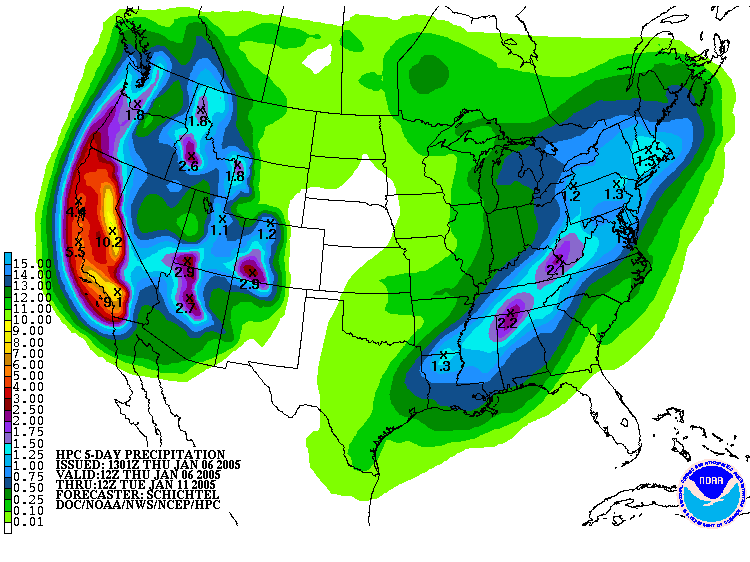
HPC 5-day Precipitation Forecast Issued 01/06/05 13z |
Weathernotes for Thursday, January 6, 2005Surface low west of California and associated upper level shortwave plow into the state on Friday producing significant rain and snow. Then a northern stream upper low dives down the west coast, combines with southern stream moisture and jet energy, and produces even more precipitation Saturday into Monday.
|
This morning, the Hydrometeorological Prediction Center (HPC) is forecasting more than 7 inches (water equivalent) of precipitation in much of the Sierra and the mountains of Southern California over the next 5 days. An ARL analysis of 12z ETA generates nearly 5 inches of rain at Los Angeles from early Friday morning through Sunday afternoon. Update 01/07/05 3:00 PM. ARL analysis of 18z ETA now generates over 7.5 inches of rain at Los Angeles from mid-morning today through Monday evening. 18z GFS continues to be much more pessimistic, generating only 3.3 inches over the same period, with a short break in the action around sunrise Sunday. Latest model runs suggest that rainy weather could extend into Tuesday. A BUFKIT analysis of 12z GFS data shows three periods of precipitation. The first two more or less run together on Friday and Saturday, followed by a break on Sunday, and then a third wave occurs on Monday. According to the analysis, the GFS produces about 3.3 inches of rain (total) Friday and Saturday at Van Nuys; then 0.6 inch on Monday. Given the wet antecedent conditions, this rain could result in many problems. Following the last wave of precipitation on Monday, the 12z GFS forecasts improving conditions with several days of dry weather. We'll see! More information concerning Southern California weather can be found using our WEATHER LINKS page. |
|
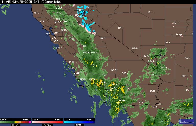 Intellicast.com Composite Radar 01/03/05 14:45z 6:45 am PST |
Weathernotes for Tuesday, January 4, 2005New rainfall records for the date were set in Chatsworth, LAX, UCLA, Oxnard, Ojai and several other locations yesterday, as yet another in a series of upper lows pumped moisture into the Southland.
|
According the the NWS Climate Summary for January 3, 2005, Downtown Los Angeles (USC) has recorded 15.45 inches of rain since the start of the water year, July 1. This is 11.4 inches more than normal, and is more than the average amount received in the course of an entire water year. This Intellicast.com Composite Radar image from 6:45 a.m. yesterday shows a well defined banded pattern of convection and heavier precipitation. The bands of enhanced convection can also be seen in this NRL IR satellite photo for the same time. These bands appear to correspond with the bands of vorticity depicted in yesterday's NCEP Non-hydrostatic Meso Model 500mb forecast for 15z. Vertical motion may have been further enhanced by diffluent flow aloft and possibly some divergence associated with a jet boundary. Is all this rain due to El Nino? According to the Seattle area forecast discussion from yesterday morning, the current pattern "appears to be getting forced by tropical convection over Indonesia and the western Pacific" and isn't typical of a central Pacific El Nino. Just what is typical of a weak to moderate central Pacific El Nino isn't as well defined as for a strong El Nino. Generally, the larger the SST anomaly in the Niño 3.4 region, the more precipitation in Southern California. This is well illustrated in this graphic of 500-hPa height and height anomalies, surface temperature anomalies and precipitation for weak, medium and strong El Ninos. (From the Climate Prediction Center's ENSO Diagnostic Discussion, issued October 7.) Also see Historic Oceanic Niño Index (ONI) & El Niño Winter & Spring Impacts on United States Weather Patterns, by Jan Null. Starting with the record rainfall in October, much of our precipitation has resulted from upper lows progressing down the west coast on the downstream side of a blocking long wave ridge. There is some evidence that the change in pattern that resulted in October's heavy rains may have been related to the Madden-Julian Oscillation. (See Real-time Weather-Climate Discussion and Predictive Insights - 3 November 2004.) The MJO has been almost non-existent since early November, perhaps indicative of the El Nino or some other ocean-atmosphere interaction. There appears to have been significant moisture advection from the sub-tropics and tropics into central and eastern Pacific mid-latitude systems in recent weeks, such as our record setting December 27-28 system, and in some cases this may have contributed to above average rainfall totals. Whatever its cause, the wet pattern is expected to continue for a least several days, with periods of rain as systems move through the area. We'll see! More information concerning Southern California weather can be found using our WEATHER LINKS page. |
|
