
NOTES ABOUT SOUTHERN CALIFORNIA WEATHER & CLIMATE
© 2000-2024 Gary Valle'. All Rights Reserved.
|
NOTES ABOUT SOUTHERN CALIFORNIA WEATHER & CLIMATE © 2000-2024 Gary Valle'. All Rights Reserved. |
IMPORTANT!! The
information presented on this web site may include errors of transcription,
interpretation, and other errors. The information may be out of date or
inaccurate. Please refer to the NATIONAL WEATHER SERVICE FORECAST OFFICE
LOS ANGELES or your local weather service office for official
forecasts and warnings. |
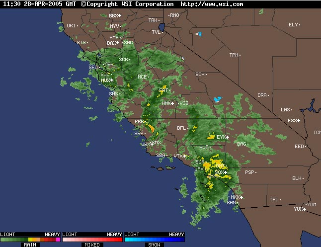 Intellicast.com Composite Radar 04/28/05 11:30z 04:30 am PDT |
Weathernotes for Thursday, April 28, 2005(Any updates will be found at the end of this discussion.) Several times in this very rainy of rain seasons a system has produced more rain in the Los Angeles area than expected, and several times the GFS computer weather forecast model has outperformed the NAM (formerly ETA) model.
|
A BUFKIT analysis of 00z NAM (formerly ETA) data produced less than 0.2 inches of rain at Van Nuys, while the 00z GFS generated more than 0.6 inch. As of 5:00 a.m. this morning, Downtown Los Angeles (USC) has recorded 1.00 inch of rain, increasing the water year total (since July 1) to 37.04 inches. This is just 1.14 inches less than the wettest rain season on record, 1883-84. A Pacific low was the basis for the rain, but a jet max and moisture entrained from the sub-tropics amplified the amount. This Intellicast composite radar image is from 4:30 a.m. when a 130 kt. jet max nosed into the coast, enhancing lift and rainfall in the area. A GOES-10 water vapor satellite image shows the general structure and circulation around the low. Will we move into #1? Based on climate norms, you would have to say probably not. According to a NWS Public Information Statement, the average rainfall for the months of May and June is only 0.37 inch. But this is anything but an "average" year. Recent runs of the GFS continue to forecast a progressive pattern with opportunities for additional rainfall. The Climate Prediction Center's 6-10 day forecast, issued yesterday, projects "normal" precipitation for Southern California, and the 8-14 day forecast "above normal." And today is not over. There's still a chance of scattered showers and perhaps an isolated thunderstorm. Ocean-atmosphere interactions originating in the tropics have seen increasing scrutiny in recent years, and it isn't surprising that there is increasing evidence of complex mechanisms and patterns that can affect our local weather -- with varying degrees of predictability. In this season of record rainfall, climate scientists have in some cases attributed heavy rainfall events to a Madden-Julian Oscillation (MJO), and in other cases to this season's central Pacific El Niño. In the last 40 days or so, a classic MJO has propagated nearly around the globe, and contrary to predictions and previous experience, what was a waning central Pacific El Niño two months ago, looks like it could be evolving into a basin wide El Niño. See the Technical ENSO Update from the IRI for a detailed assessment of the current ENSO state. We'll see! More information concerning Southern California weather can be found using our WEATHER LINKS page. |
|
