
NOTES ABOUT SOUTHERN CALIFORNIA WEATHER & CLIMATE
© 2000-2024 Gary Valle'. All Rights Reserved.
|
NOTES ABOUT SOUTHERN CALIFORNIA WEATHER & CLIMATE © 2000-2024 Gary Valle'. All Rights Reserved. |
IMPORTANT!! The
information presented on this web site may include errors of transcription,
interpretation, and other errors. The information may be out of date or
inaccurate. Please refer to the NATIONAL WEATHER SERVICE FORECAST OFFICE
LOS ANGELES or your local weather service office for official
forecasts and warnings. |
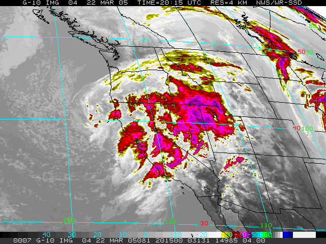 GOES-10 IR Satellite Photo 03/22/05 20:15z 12:15 pm PST |
Weathernotes for Wednesday, March 23, 2005(Any updates will be found at the end of this discussion.) All Downtown Los Angeles (USC) needed to move into the #2 spot for the wettest rain season on record was 0.04 inches rain. It received more than an inch, once again flooding streets, drenching hillsides, and causing various weather related problems. It hasn't rained this much in 120 years! |
If you 're wondering about that #1 ranking, it belongs to 1883-84 when 38.18 inches was recorded. So far this water year (July 1, 2004 to June 30, 2005) Downtown Los Angeles (USC) has recorded 35.89 inches of rain. That leaves us "only" 2.29 inches behind the rainiest of Los Angeles rainy seasons. Will we move into #1? A couple of inches of rain doesn't sound like a lot in a rain season where we have received nearly three feet of rain. But rain in Southern California is often a precious commodity. It was only three years ago when we had the driest rainfall season on record with 4.42 inches of rain for the entire water year! Showers on Thursday could increase our rainfall total a little, but the California Nevada River Forecast Center (CNFRC) forecasts under 0.2 inch of precipitation at Los Angeles and the HPC only about 0.05. Beyond tomorrow the GFS forecasts a progressive pattern with zonal to quasi-zonal flow at the mid latitudes, which should periodically produce additional chances of rain through the first week of April. Today's NWS 6-10 day and 8-14 day outlook specifies above average precipitation in Southern California. Given this season's inclination to produce "stronger than expected" precipitation. there's a chance we'll break the rainfall record over the next 30 to 60 days, but it's far from being a done deal. We'll see! The CNFRC has posted a detailed report regarding the February 17-23, 2005 Southern California Heavy Rainfall Event. NOAA News Online has published an article, NOAA IDENTIFIES CAUSES FOR LATEST WET WEATHER IN WEST, which relates the February rainfall event to ocean-atmosphere coupling associated with El Nino conditions in the central Pacific, rather than the Madden-Julian Oscillation (MJO). It is interesting to note that eastward propagating MJO like conditions were indicated by the BMRC's Multivariate MJO Index for the period January 31 to about February 10th or 11th. This can also be seen in this BMRC MJO animation for the month of February. Could this MJO like activity have played a role in the initial development of the area of persistent convection near the date line, perhaps triggering or strengthening the convection and resulting ocean-atmosphere coupling attributed to the central Pacific El Niño? More information concerning Southern California weather can be found using our WEATHER LINKS page. |
|
