
NOTES ABOUT SOUTHERN CALIFORNIA WEATHER & CLIMATE
© 2000-2024 Gary Valle'. All Rights Reserved.
|
NOTES ABOUT SOUTHERN CALIFORNIA WEATHER & CLIMATE © 2000-2024 Gary Valle'. All Rights Reserved. |
IMPORTANT!! The
information presented on this web site may include errors of transcription,
interpretation, and other errors. The information may be out of date or
inaccurate. Please refer to the NATIONAL WEATHER SERVICE FORECAST OFFICE
LOS ANGELES or your local weather service office for official
forecasts and warnings. |
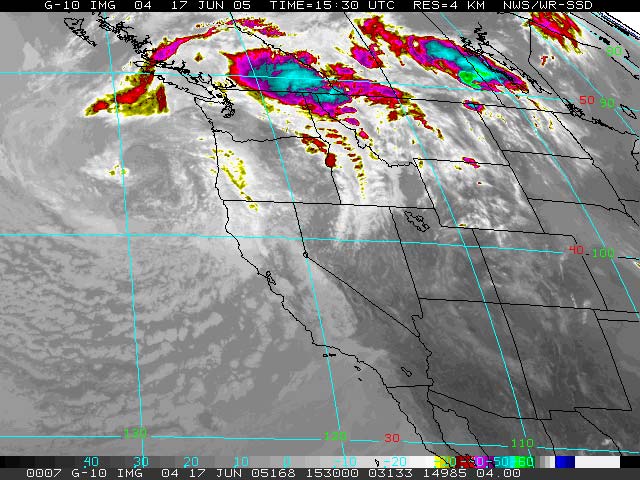 GOES-10 IR Satellite Photo 06/17/05 15:30z 8:30 am PDT |
Weathernotes for Tuesday, June 21, 2005(Any updates will be found at the end of this discussion.) An unseasonably strong upper level low spinning off the Oregon coast produced some rain and showers in Northern California, and even a little snow in the Sierra last week, but in the southern half of the state its primary effect was to cool temperatures and slow the Spring snowmelt and runoff.
|
Looks like we're probably going to have the second wettest rain season on record, with (unofficially) 37.25 inches of rain recorded at Downtown Los Angeles (USC) for the period July 1, 2004 through June 30, 2005. That is, unless something very unusual happens. Funny thing is, the 06/21/05 12z GFS actually showed a trough moving through Southern California in the June 26-27 timeframe and even threw a little moisture and vorticity into the mix. The dry frontal boundary that cleared out the basin and cooled temps last Thursday afternoon was unusual. An active front with precipitation in late June would be remarkable. Later models runs depict a much weaker trough with little chance of any precipitation in the Los Angeles area. Model runs also show monsoonal moisture remaining east of the area. Klaus Wolter's Multivariate ENSO Index (MEI) for April/May increased from 0.56 to 0.71, ranking it a "still respectable" 44th of 56 values, where 1 is the strongest La Nina, and 56 the strongest El Niño for the bi-monthly value. This puts the MEI well within the "weak" tercile threshold for ranked El Niño events in April/May, and just below the "moderate" quintile El Niño threshold. MJO activity has waned in recent weeks, and following the arrival of a strong Kelvin wave in the eastern Pacific in late April, and a temporary increase in SST anomaly, the equatorial Pacific has returned to a cooler state, similar to that observed in June of 2003 and 2004. Current ENSO forecasts are mixed, with some predicting neutral conditions over the next few months, and others forecasting warm conditions. These are referenced in the CPC's Forecast Forum, and the Australian Bureau of Meteorology National Climate Centre's summary of Forecast ENSO Conditions. We should have a better idea of whether we'll be dealing with another El Nino this Winter by late July or early August. We'll see! More information concerning Southern California weather can be found using our WEATHER LINKS page. |
|
