
NOTES ABOUT SOUTHERN CALIFORNIA WEATHER & CLIMATE
© 2000-2024 Gary Valle'. All Rights Reserved.
|
NOTES ABOUT SOUTHERN CALIFORNIA WEATHER & CLIMATE © 2000-2024 Gary Valle'. All Rights Reserved. |
IMPORTANT!! The
information presented on this web site may include errors of transcription,
interpretation, and other errors. The information may be out of date or
inaccurate. Please refer to the NATIONAL WEATHER SERVICE FORECAST OFFICE
LOS ANGELES or your local weather service office for official
forecasts and warnings. |
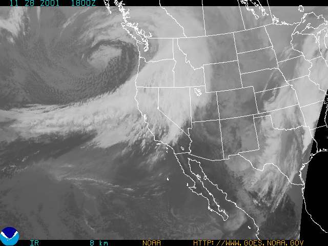
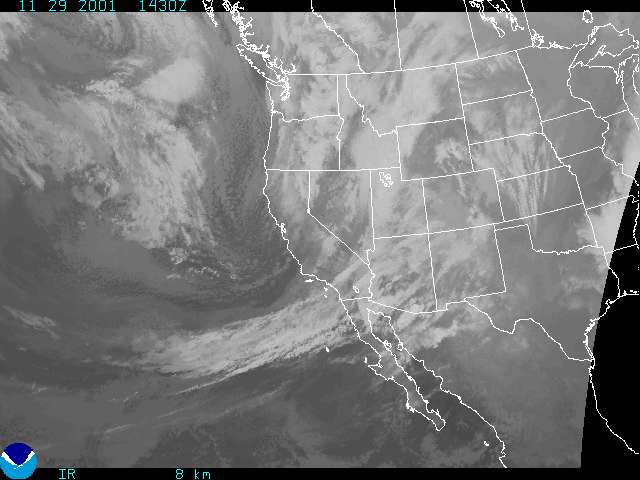 GOES-10 IR 11/29/01 1430z |
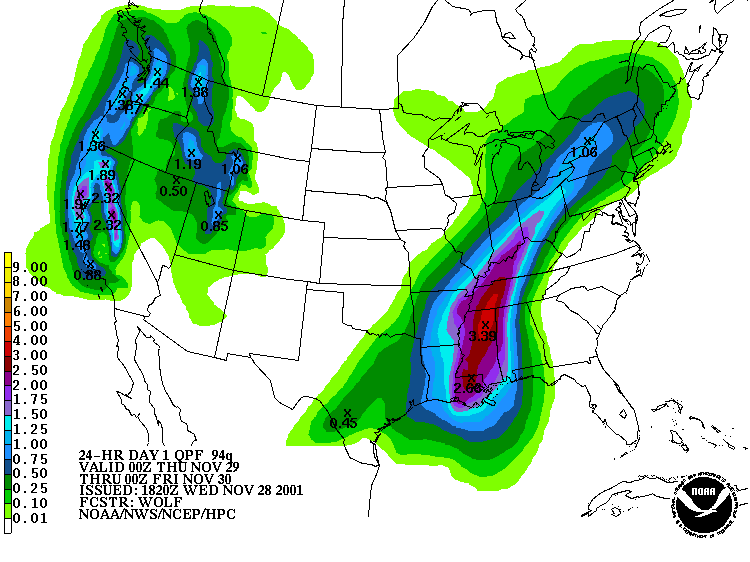
Weathernotes for Thursday, November 29, 2001Today's fast-paced system appears to be a few hours ahead of schedule. A satellite photo from 6:30 this morning shows the front already moving through the L.A. area. In contrast to last Saturday's system, today's front, trough and dynamics are out of sync, at least in Southern California. |
|
There was sufficient moisture. This morning's sounding at Vandenberg recorded a precipitable water value of nearly an inch. But lifting mechanisms associated with the front were weak and rainfall so far has been less than spectacular. This morning, RAMDIS shows the axis of the trough moving onshore fairly rapidly, and radar indicates scattered instability showers over much of the state. Based on the behavior of recent systems, there is some expectation that the system originally forecast for the Sunday-Monday timeframe may arrive earlier. The 12z AVN moves the system into the L.A. area Sunday, but appears to be somewhat faster with the system than the 18z ETA. Current HPC QPF forecasts appear to favor a slower solution, but that may change tomorrow. Today's CPC/NCEP Outlooks depicted "Above Normal" precipitation for the 6-10 day period and "Normal" for the 8-14 day period for Southern California. Week two precipitation probabilities centered on Dec. 10 are average, perhaps signaling a respite in the current wet pattern. More information concerning Southern California weather can be found using our WEATHER LINKS page. |
|
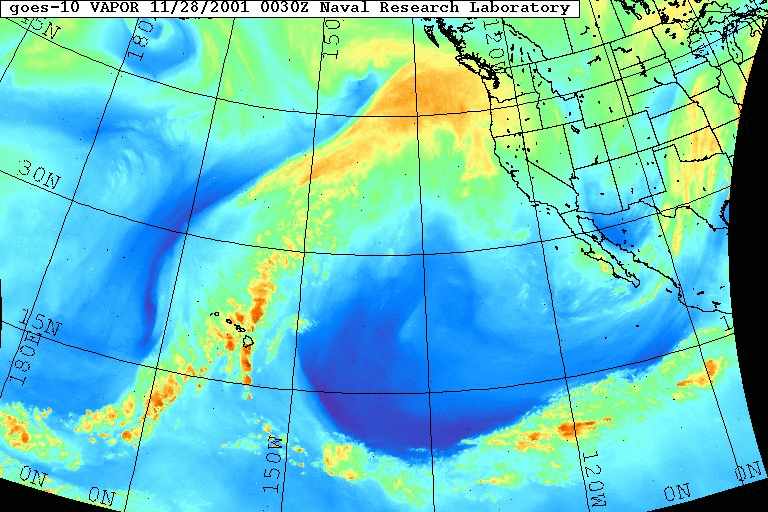
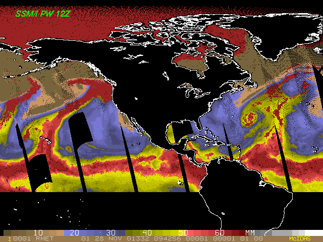 SSMI Precipitable Water 11/28/01 12z |
Weathernotes for Wednesday, November 28, 2001SSMI based analysis of precipitable water values from early this morning appears to show a remarkable moisture connection from the Intertropical Convergence Zone, near the equator, to latitudes of about 50N. Satellite based analysis of upper winds and water vapor from yesterday afternoon show the transport pattern. Some of this moisture may have been entrained in the system bringing locally heavy rain and snow to the Northwest today, and moving down the coast into Southern California tomorrow. |
|
The current HPC QPF forecast for the 24 hr. period ending 4 PM Thursday shows 2+ inch snow water equivalents in the Sierra, suggesting the addition of another 18-24 inches of snow to the snowpack at higher elevations of the range. In the Los Angeles area, storm totals of about 1 inch are expected, with locally heavier amounts in orographically favored foothill and mountain areas. At the moment forecasters expect rain to reach the L.A. area by tomorrow afternoon. Ensemble forecasts continue to suggest a wet pattern for the West Coast over the next two weeks, but are forecasting a lower probability of precipitation in Southern California than areas to the north. Particularly toward the end of the period. We'll see! Yesterday's CPC/NCEP Outlooks depicted "Above Normal" precipitation for the 6-10 day period and "Above Normal" for the 8-14 day period for Southern California. More information concerning Southern California weather can be found using our WEATHER LINKS page. |
|
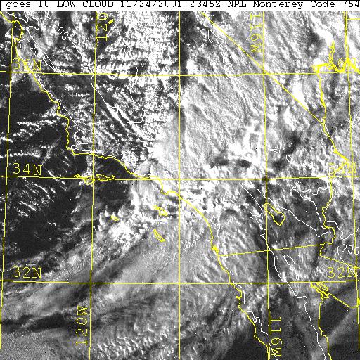 GOES-10 VISIBLE 11/24/01 2345z |
Weathernotes for Sunday, November 25, 2001What yesterday's storm lacked in duration, it made up for in intensity, bringing heavy rains and strong gusty winds to the area. (1 km resolution GOES-10 Visible Satellite Photo from NRL Monterey taken at about 3:45 PM yesterday.) Selected preliminary 24 hr. rainfall totals through 8:00 this morning: San Marcos Pass 1.97, Gibralter Dam 1.02, Carpinteria F.S. 1.42, NF Matilija Ck. 1.65, Ventura 1.50, Cheseboro 0.74, Aliso Canyon 1.65, Hollywood Res. 1.89, Santa Anita Dam 1.61, Big Bear 2.00, San Onofre 0.91, Poway 0.63. |
|
Ensemble forecasts suggest a continued wet pattern for the West Coast over the next two weeks, but medium range models have been waffling on the southern extent of the systems and associated precipitation. We'll see! Yesterday's CPC/NCEP Outlooks depicted "Above Normal" precipitation for the 6-10 day period and "Normal" for the 8-14 day period for Southern California. More information concerning Southern California weather can be found using our WEATHER LINKS page. |
|
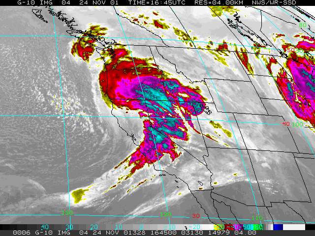 GOES-10 IR 11/24/01 1645z |
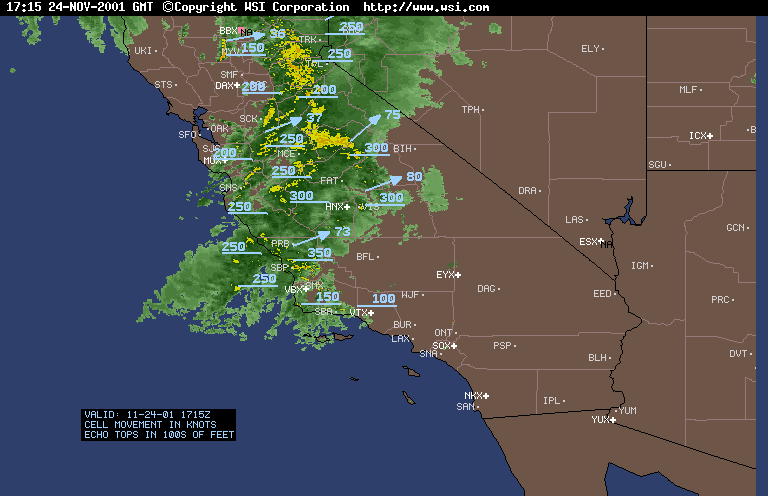
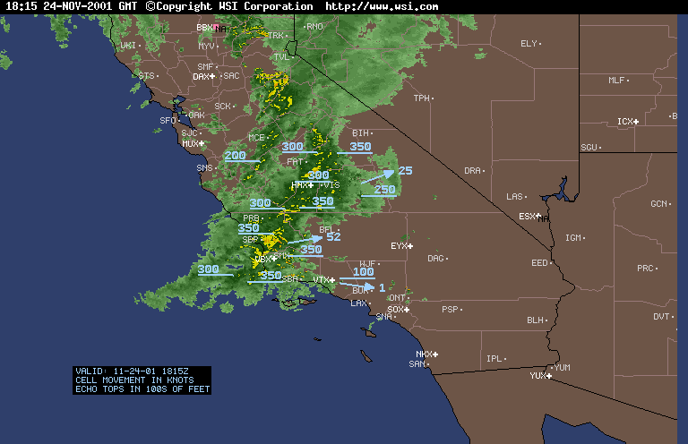
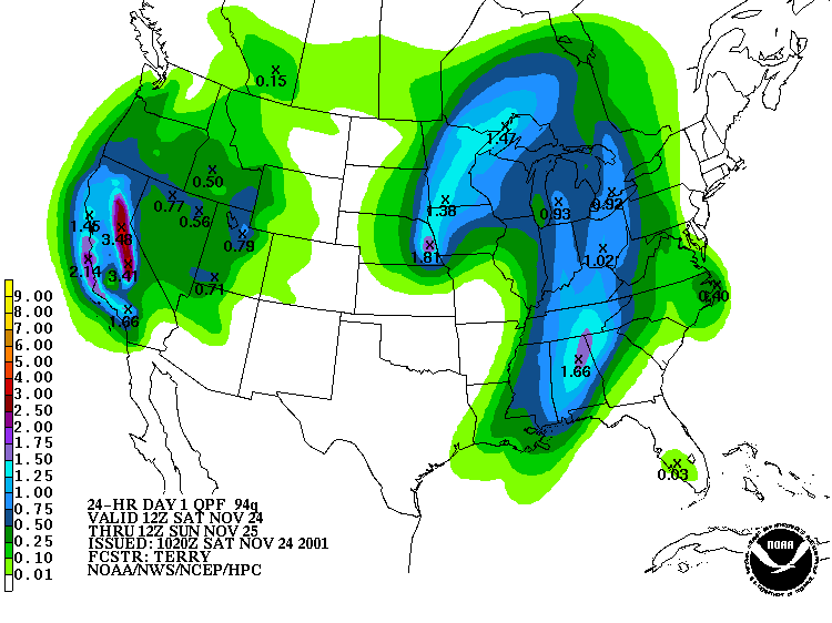
Weathernotes for Saturday, November 24, 2001California is going to be hammered today by a strong, but fast moving, mid-latitude Pacific system. A combination of favorable orographics, moisture, jet stream and vorticity maxima could produce substantial precipitation, especially in the Sierra. One limiting factor is the speed the system is moving through the state. Intellicast radar shows the position at 9:15 AM and at 10:15 AM. |
|
The HPC QPF forecast for the 24 hr. period ending 4:00 am Sunday morning shows as much as 3.5 inches of precipitation along the spine of the Sierra. In Southern California the storm is expected to result in about 1.0 inch of rain with up to 2.0 inches in some mountain areas. Ensemble forecasts suggest a continued wet pattern for the West Coast over the next two weeks, but medium range models have been waffling on the southern extent of the systems and associated precipitation. We'll see! Yesterday's CPC/NCEP Outlooks depicted "Normal" precipitation for the 6-10 day period and "Normal" for the 8-14 day period for Southern California. More information concerning Southern California weather can be found using our WEATHER LINKS page. |
|
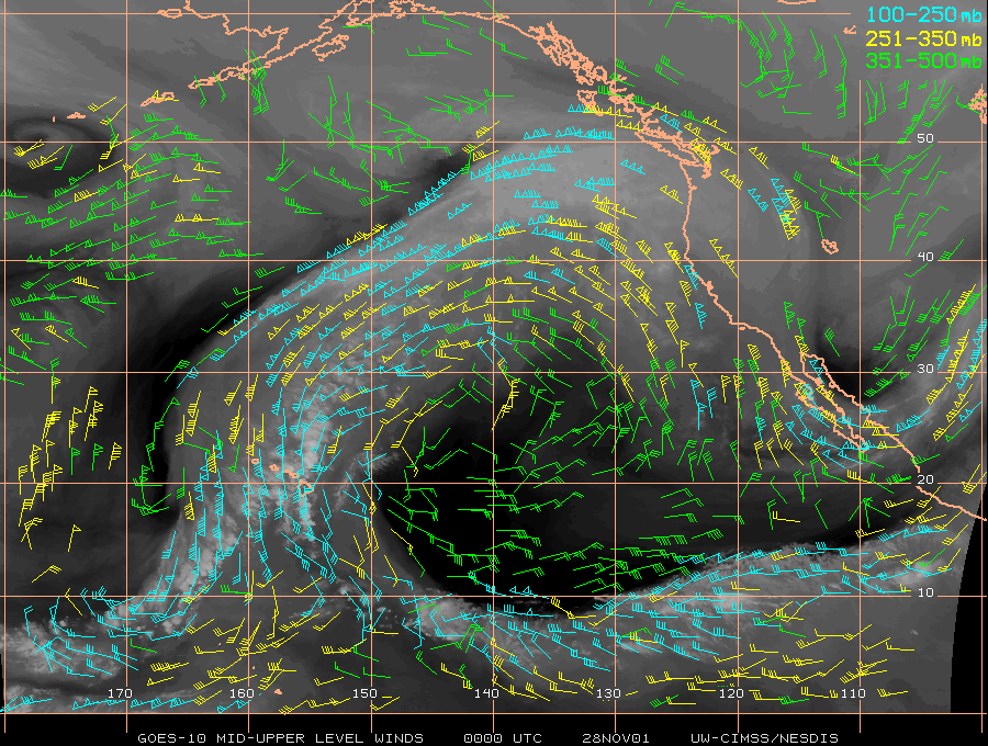
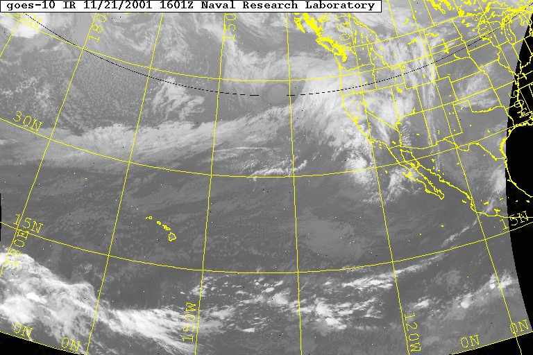
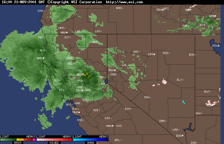
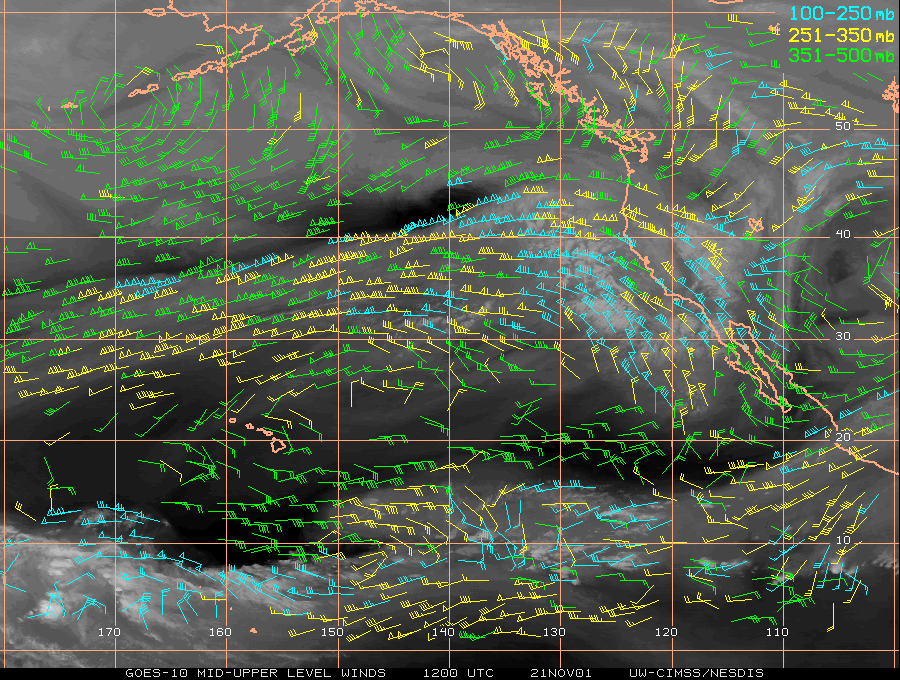 GOES-10 Upper Level Winds 11/21/01 12x |
Weathernotes for Wednesday, November 21, 2001A moderately moist westerly flow associated with a strong 150 kt jet extends across the eastern Pacific between 30-40N out to dateline. The jet is currently targeting the northern half of the state and Intellicast radar from this morning shows the resulting precipitation. |
|
At the moment, models, HPC QPF forecasts, and other guidance indicates that Northern and Central California should remain the precipitation focus through Friday. The 12z ETA and AVN suggest that showers could make it as far south as Point Conception and the north slopes of the Tehachipis on Thanksgiving. Current guidance says that Friday should be dry over most of Southern California with rain probable Saturday or Saturday night. Ensemble forecasts suggest this weekend's system may be just the first of several systems to affect California over the next week or so. Yesterday's CPC/NCEP Outlooks depicted "Above Normal" precipitation for the 6-10 day period and "Above Normal" for the 8-14 day period for Southern California. More information concerning Southern California weather can be found using our WEATHER LINKS page. |
|
 MRF 11/18/01 00z |
Weathernotes for Sunday, November 18, 2001Thanksgiving Day is just a few days away! How was the date for Thanksgiving determined? According to Thanksgiving in American History, days of Thanksgiving have been proclaimed throughout the year, even in mid-summer. Our modern celebration is due in part to the efforts of Sarah Josepha Hale. Hale reportedly "labored for decades" for the "return to the morality and simplicity of days gone by," and in 1863 President Lincoln declared the last Thursday of November as a national day of Thanksgiving. Later it was changed to the next-to-the-last Thursday of November by President Franklin D. Roosevelt, and then back again a couple of years later. In 1941 Congress set the date to the fourth Thursday in November; where it remains today. |
|
Today's run of the MRF, and other guidance, suggests that Northern California will be the focus of a multi-day rain event beginning Monday and lasting through Thanksgiving. According to the models the jet stream is expected to buckle and shift southward later in the week, and by next Saturday or Sunday, Southern California could see some rain. Today's CPC/NCEP Outlooks depicted "Above Normal" precipitation for the 6-10 day period and "Above Normal" for the 8-14 day period for Southern California. More information concerning Southern California weather can be found using our WEATHER LINKS page. |
|
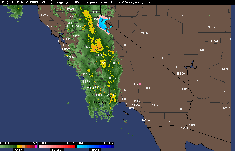
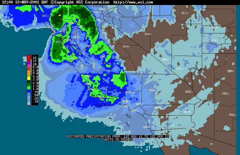 Intellicast Radar 24 Hr. Precipitation Estimate |
Weathernotes for Tuesday, November 13, 2001A strong trough and associated cold front moved through California yesterday resulting in moderate to heavy rain over much of the state. Rainfall amounts varied widely, with some stations in Northern California recording as much as 3 to 4 inches of precipitation. The cold front snapped through the Los Angeles area like the tail of a whip, with much of the rain falling in a one hour period late yesterday afternoon. |
|
Some rainfall totals for the 24 hr. period ending at 4:00 am: Los Angeles (USC) 0.35, Agoura 0.63, Canoga Park 0.43, Pacoima Dam 0.79, OPIDS Camp 1.13, Santa Maria 1.52. At the moment, it looks like dry weather will prevail in Southern California through Thursday, and perhaps through the weekend. A weak cold front could result in some clouds on Saturday. Yesterday's CPC/NCEP Outlooks depicted "Below Normal" precipitation for the 6-10 day period and "Below Normal" for the 8-14 day period for Southern California. Forecast confidence for the 6-10 day period was 4 on a scale of 1-5, and for the 8-14 day period was 3. More information concerning Southern California weather can be found using our WEATHER LINKS page. |
|
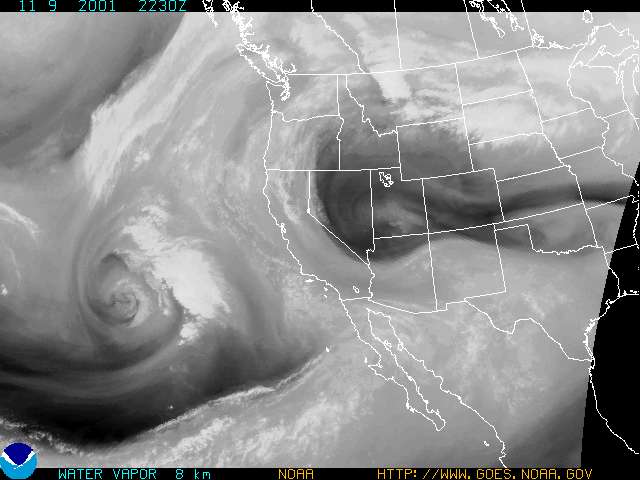
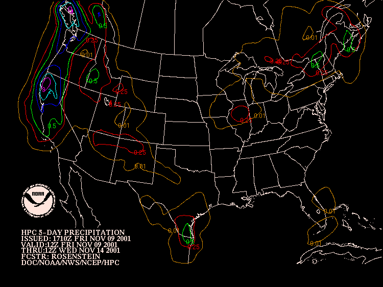 HPC 5 day Precip Forecast 12z Friday to 12z Wednesday 11/14/01 |
Weathernotes for Friday, November 9, 2001Unsettled weather is expected in Southern California over the next few days with at least a chance of some drizzle, light showers, or even rain; depending on how an approaching upper low and following troughs evolve. There is some disparity in the computer models and this is reflected in HPC's 5-day precipitation forecast which limits most of the precipitation to Central and Northern California. |
|
At the moment, it looks like there is a chance of showers beginning Saturday afternoon from Santa Barbara northward, perhaps extending into the Los Angeles basin overnight on Saturday. Sunday into Monday looks unsettled over most of the area with an increasing chance of showers, or possibly rain, Monday afternoon or evening. Through the period there should be a better chance of precipitation in northern areas of Southern California, than in the south, with the caveat that the latest (18z) run of the AVN is wetter in the south Monday afternoon/evening than in earlier runs. Today's CPC/NCEP Outlooks depicted "Below Normal" precipitation for the 6-10 day period and "Below Normal" for the 8-14 day period for Southern California. Forecast confidence for the 6-10 day period was 3 on a scale of 1-5, and for the 8-14 day period was 1. More information concerning Southern California weather can be found using our WEATHER LINKS page. |
|
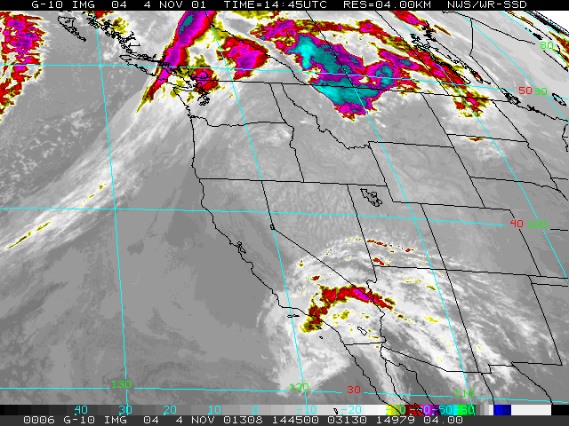 GOES 10 IR 11/04/01 1445z |
Weathernotes for Sunday, November 4, 2001An upper level low spinning off the coast has entrained some subtropical moisture and is providing enough lift to result in widespread cloudiness, with some scattered light showers across the area. Most of the moisture is in the upper levels and not much is reaching the ground. Very few stations have recorded more than a trace. More information concerning Southern California weather can be found using our WEATHER LINKS page. |
