
NOTES ABOUT SOUTHERN CALIFORNIA WEATHER & CLIMATE
© 2000-2024 Gary Valle'. All Rights Reserved.
|
NOTES ABOUT SOUTHERN CALIFORNIA WEATHER & CLIMATE © 2000-2024 Gary Valle'. All Rights Reserved. |
IMPORTANT!! The
information presented on this web site may include errors of transcription,
interpretation, and other errors. The information may be out of date or
inaccurate. Please refer to the NATIONAL WEATHER SERVICE FORECAST OFFICE
LOS ANGELES or your local weather service office for official
forecasts and warnings. |
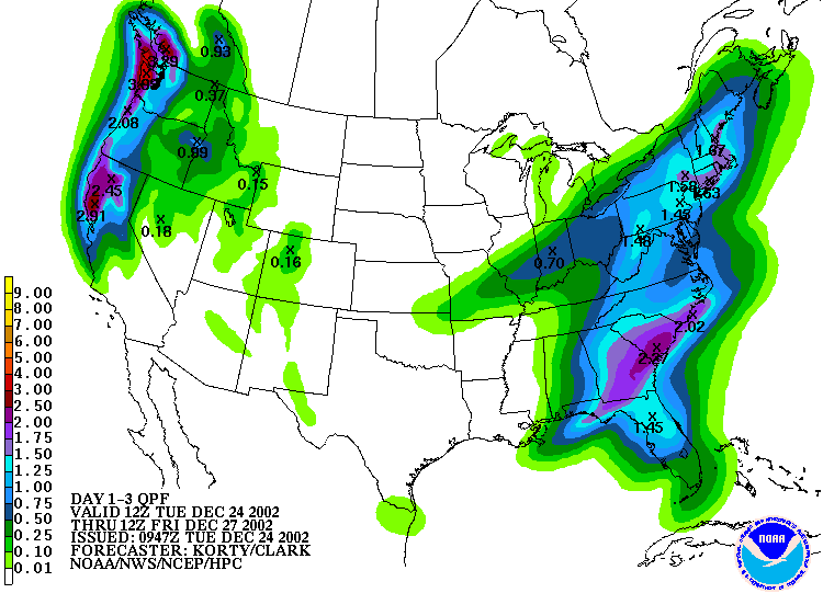
HPC 3 Day QPF Forecast from 12/24/02 12z (4:00 am) |
Weathernotes for Tuesday, December 24, 2002Southern California's weather for Christmas Eve, and Christmas has been trending drier with each run of the ETA and AVN computer models. The HPC 3-day precipitation forecast mirrors the models and limits any rainfall over the next three days to areas north of Pt. Conception. |
|
Generally, the medium range models are suggesting a shift in the storm track to the northern half of California and north through the Pacific Northwest. But that's not to say that Southern California won't see any rain. Ensemble forecasts maintain a slight chance of precipitation as the impulses pass to our north, with the chance higher the further north you go. The next good chance for rain in the Los Angeles area looks to be this weekend. We'll see! More information concerning Southern California weather can be found using our WEATHER LINKS page. |
|
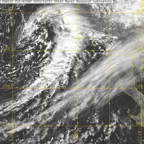
GOES-10 VIS 12/21/02 2016z 12:16 pm PST |
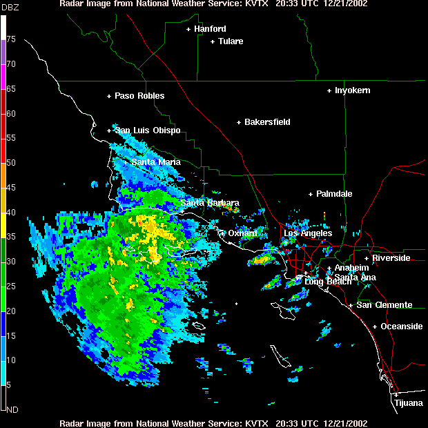
Weathernotes for Saturday, December 21, 2002A little after noon, RAMDIS shows a cold upper low tracking southeast towards the Southern California coast with NWS radar indicating strong convection and precipitation in a developing baroclinic zone. The low is forecast to remain off shore and follow a southeasterly path along the coast this afternoon and evening. Thunderstorms and good orographics could produce very heavy rain in the coastal sections of Santa Barbara and Ventura counties. |
|
The 11:00 am precipitation forecast for the Los Angeles area projects between 0.25 and 0.75 inches of rain through tonight. Isolated larger amounts could occur in areas affected by thunderstorms or in orographically favored foothill or mountain locations. Thursday night's storm resulted in rainfall amounts generally ranging from about 0.5 inch to about 1.5 inches. San Marcos Pass, near Santa Barbara received over 3.5 inches of rain. As of December 20, the total rainfall for Los Angeles since July 1 was 5.55 inches, which is 2.58 inches above normal. Over the next couple of days the weather is expected to generally improve. Sunday is forecast to be partly cloudy, cool and windy. Monday looks mostly clear. Increasing clouds are expected Christmas Eve, leading to a chance of a shower, mainly in the areas north of Los Angeles. At the moment Christmas day is forecast to be partly cloudy and cool. We'll see! More information concerning Southern California weather can be found using our WEATHER LINKS page. |
|
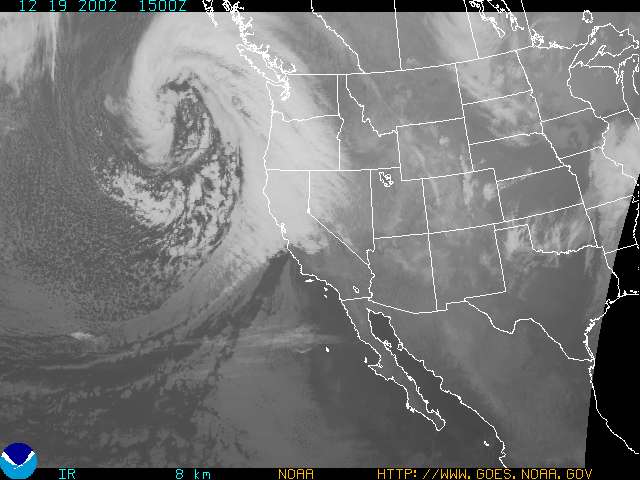
GOES-10 IR 12/19/02 1500z 7:00am PST |
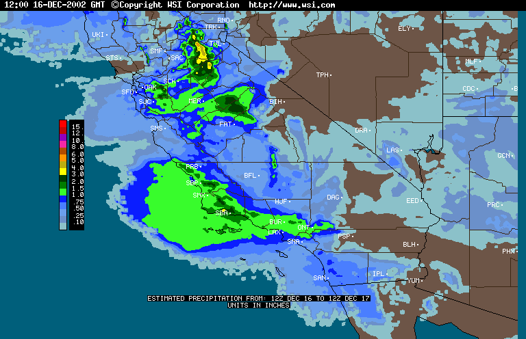
Weathernotes for Thursday, December 19, 2002This morning's cold and clear skies will give way to increasing clouds today, leading to rain tonight, as a second powerful Pacific system in a week long series of storms slams into the west coast and sweeps north to south through California. Rainfall amounts are forecast to be similar to Monday's record setting storm in which Los Angeles (USC) received nearly 2 inches of rain, breaking a record set in 1940. Rainfall amounts across the area generally ranged from about 1.25 to 2.5 inches. Here is the precipitation distribution indicated by the WSI Intellicast Precipitation Estimate |
|
A BUFKIT analysis of 12/19/02 00z data for Van Nuys indicates rain, heavy at times, beginning about 7:00 or 8:00 pm and turning to scattered showers mid-morning on Friday. About 1.3 inches of rain is forecast for Van Nuys overnight. Instability behind the front could result in isolated heavy showers on Friday. Strong, gusty winds are expected to accompany the storm. More information concerning Southern California weather can be found using our WEATHER LINKS page. |
|
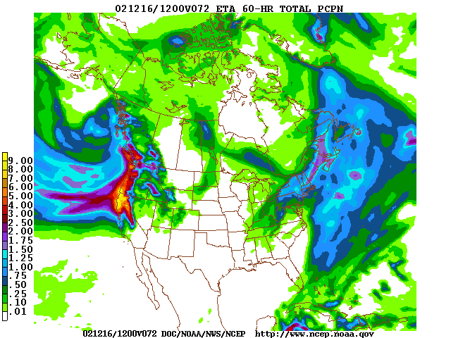
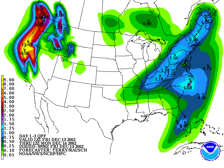
NCEP ETA 60 hr Precip Forecast from 12z 12/13/02 |
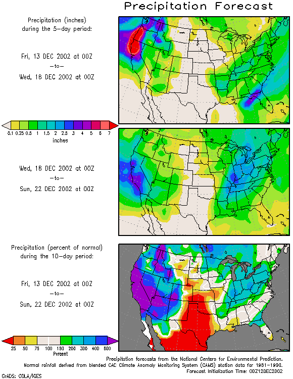
Weathernotes for Friday, December 13, 2002A series of Pacific systems will bring very wet weather to Northern and Central California over the next several days with the storm track forecast to eventually sag southward and target Southern California. This morning's ETA forecast of precipitation over the next 60 hours shows large amounts occurring in northwestern California and the northern Sierra. The HPC three day QPF forecast shows as much as 14 inches of rain falling along the northwest coast over the next three days. |
|
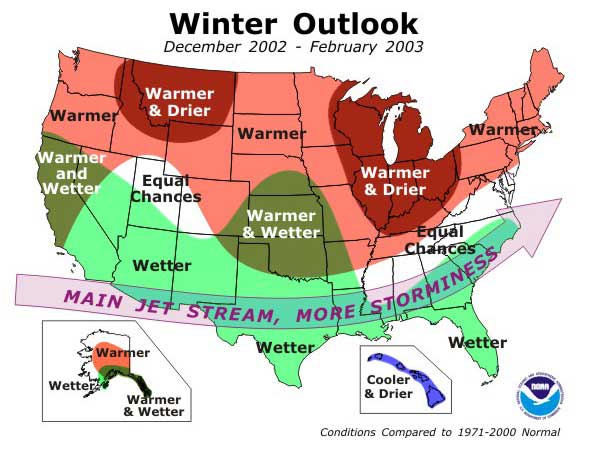
At the moment. computer models and other guidance suggest that through the weekend and into Monday, most of the precipitation should be limited to areas north of Pt. Conception. Starting Monday night the emphasis shifts south and the Southland could see significant rainfall. The 10-Day Precipitation Outlook for the Conterminous U.S., based on the AVN forecast, shows how the wet weather is expected to shift south. The weather this Fall appears to have been increasingly influenced by El Nino. NOAA released it's latest Winter Outlook yesterday. As expected, El Nino is forecast to play an important role in the nation's Winter, with above average rainfall projected in Southern California and most of the southern tier of states. More information concerning Southern California weather can be found using our WEATHER LINKS page. |
|
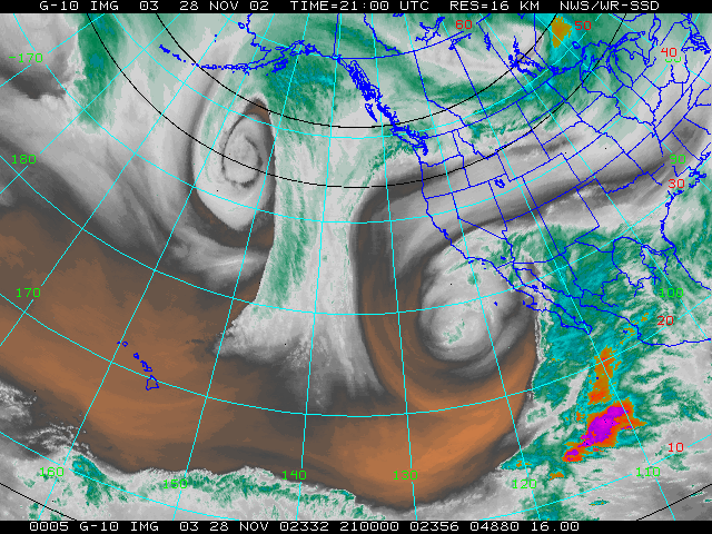
GOES-10 WV from 21z 11/28/02 |
Weathernotes for Saturday, December 1, 2002The upper level low that would eventually produce showers in Southern California at the week's end formed over Las Vegas on Sunday. It remained near the juncture of Nevada, California and Arizona thru Tuesday morning, when it started to retrograde to the southwest, tapping into tropical moisture and pulling it into Mexico. By the morning of the 27th (Wednesday) the low had moved offshore, and was continuing to direct moisture into Mexico and producing some showers in the San Diego area. |
|
On the 28th (Thursday) the low remained offshore. Finally on Friday the low started to move inland, producing convective showers across the southern half of California on Friday and Saturday. Amounts varied widely, but generally ranged from about 0.1 inch to about 0.5 inch. Widely scattered showers persisted into Sunday. At the moment the NCEP Ensemble forecasts suggest most of the precipitation over the next 6-10 days should be limited to the northern two-thirds of the state. More information concerning Southern California weather can be found using our WEATHER LINKS page. |
|
