NOTES ABOUT SOUTHERN CALIFORNIA WEATHER & CLIMATE
© 2000-2024 Gary Valle'. All Rights Reserved.
|
NOTES ABOUT SOUTHERN CALIFORNIA WEATHER & CLIMATE © 2000-2024 Gary Valle'. All Rights Reserved. |
IMPORTANT!! The
information presented on this web site may include errors of transcription,
interpretation, and other errors. The information may be out of date or
inaccurate. Please refer to the NATIONAL WEATHER SERVICE FORECAST OFFICE
LOS ANGELES or your local weather service office for official
forecasts and warnings. |
Previous Month - Index - Next
|
First Autumn Cold Front.
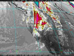
Mixed El Niño Signals Continue. The frontal band associated with the first Pacific upper level low system and trough of Autumn 2009 is producing some showers in Central California. Some snow showers could occur at the higher elevations of the Sierra. A strong onshore flow has dramatically cooled temperatures throughout the state. |
Today's cool temps are a welcome respite from several days of hot weather. Wednesday and Thursday of last week, Downtown Los Angeles (USC) recorded a high of 100°F; and Saturday, Woodland Hills (Pierce College) reported a high of 107°F. Temperatures are expected to rebound Wednesday, Thursday and Friday, but are forecast to cool again over the weekend. Similar to what occurred in July there has been little change in equatorial Pacific SST anomalies, the Southern Oscillation Index (SOI) has switched from negative to positive, the Aug-Sep Multivariate ENSO Index (MEI) value is not expected to significantly increase, and the Global Wind Oscillation (GWO) has dropped its orbit to a lower relative AAM state. On the plus side, a large area of enhanced convection has redeveloped in the West Central Pacific from about 150E to the dateline, and another of a series of Westerly Wind Bursts (WWB) is occurring -- the strongest observed so far during this ENSO transition. This WWB will likely be followed by another eastward propagating downwelling Kelvin wave, which could help increase upper-ocean heat content anomalies in the equatorial Pacific. Moderate El Niños come in many flavors and have varying impacts. Under the guise of such El Niños Los Angeles experienced its second wettest water year on record in 2004-2005, when 37.25 inches of rain was recorded; then in 2006-2007 had its driest water year on record, when only 3.21" was recorded. More information concerning Southern
California weather can be found using our WEATHER
LINKS page. |
|
or Press your Browser's BACK button.