NOTES ABOUT SOUTHERN CALIFORNIA WEATHER & CLIMATE
© 2000-2024 Gary Valle'. All Rights Reserved.
|
NOTES ABOUT SOUTHERN CALIFORNIA WEATHER & CLIMATE © 2000-2024 Gary Valle'. All Rights Reserved. |
IMPORTANT!! The
information presented on this web site may include errors of transcription,
interpretation, and other errors. The information may be out of date or
inaccurate. Please refer to the NATIONAL WEATHER SERVICE FORECAST OFFICE
LOS ANGELES or your local weather service office for official
forecasts and warnings. |
Previous Month - Index - Next Month
|
A Few Sprinkles Around Southland.
MEI Exceeds El Niño Threshold. A shortwave wrinkle in a broad upper trough over the West, associated vorticity, and an 80 kt. jet max nosing into Southern California combined to produce a few showers in the area this morning. The NCEP WESTNMM high resolution model indicated the vorticity and jet max in its forecast. |
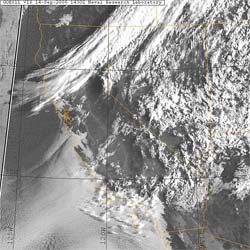
All of this is ahead of cold front forecast to move through the area during the day tomorrow (Friday). This GOES-11 Visible satellite photo from 7:30 this morning shows the front moving through Northern California, as well as the marine layer and mid-level clouds over our area. (Note the cloud shadows on the stratus.) The cold front isn't expected to produce any rain in the Los Angeles area, and should result in a beautiful Fall-like weekend with mostly clear skies and moderate temperatures. We'll see! Dr. Klaus Wolter's Multivariate ENSO Index (MEI) for July/August increased to 0.75, and as Dr. Wolter points out, this is a an increase of more than 1.3 standard deviations in four months, and moves the MEI well above the weak El Niño threshold, as defined by the index. A TAO/TRITON 5-day depth average temperature section plot inidcates a large area with averaged subsurface (surface to 300m) temperature anomalies exceeding 1°C. More information concerning Southern
California weather can be found using our WEATHER
LINKS page. |
|
or Press your Browser's BACK button.