
NOTES ABOUT SOUTHERN CALIFORNIA WEATHER & CLIMATE
© 2000-2024 Gary Valle'. All Rights Reserved.
|
NOTES ABOUT SOUTHERN CALIFORNIA WEATHER & CLIMATE © 2000-2024 Gary Valle'. All Rights Reserved. |
IMPORTANT!! The
information presented on this web site may include errors of transcription,
interpretation, and other errors. The information may be out of date or
inaccurate. Please refer to the NATIONAL WEATHER SERVICE FORECAST OFFICE
LOS ANGELES or your local weather service office for official
forecasts and warnings. |
Previous Month - Index - Next Month
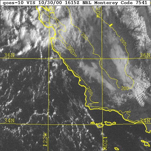 GOES 10 VISIBLE 10/30/00 1615z |
Weathernotes for Monday, October 30, 2000As it turns out the 00Z 10/24/00 run of the MRF did a pretty good job of modeling our recent wet weather. Here's precipitation map for the 24 hours preceding 10/30/00 at 12z. This map is from the EMC Precipitation Forecast Verification page and is based on Stage IV analysis data. This morning's visible satellite photo shows the new snow in the Sierra. It also shows mountain wave clouds over the Tehachapis, low clouds piled into the southern end of the San Joaquin Valley, clouds associated with a vorticity max near Monterey, and an interesting cellular convection pattern over the relatively warm ocean. |
|
The next shortwave is forecast to be an "inside slider," digging into Nevada, then eventually merging with the trough now over California as it moves east. The system then moves back to the west and cuts off into yet another upper low over Southern California. Computer models forecast this to happen in the Thursday-Friday timeframe. If the system evolves as currently forecast, it could produce some precipitation on the east side of the Sierra, the eastern deserts, or southeastern California, but there is a lot of uncertainty in the location of the low and the amount of moisture associated with the system. The CDC "Week 2" forecasts for the period November 7 to 13 hint at continued troughiness in the southwest with a somewhat increased chance of precipitation in Southern California. More information concerning Southern California weather can be found on our WEATHER LINKS page. |
|
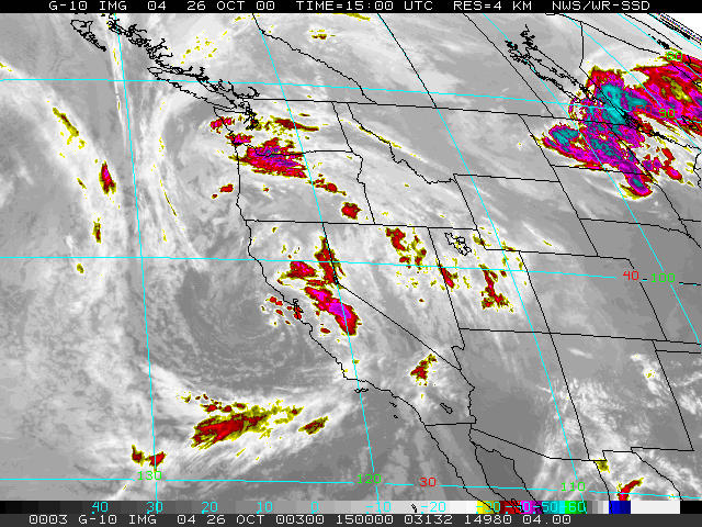 GOES-10 10/26/00 1500Z |
Weathernotes for Thursday, October 26, 2000Nicely developed upper low just off the central California coast progged to continue moving down the coast into southern California and northern Mexico. Radar at 1545Z showed rain extending southward to near a Vandenberg - Bakersfield line. Ship and buoy observations suggest pressures of associated surface low at about 1006 mb. HPC QPF forecast for today shows a precipitation maxima of 1.36 inches along the central California coast. |
|
Computer models continue to show another trough moving through the West on the weekend. The most recent MRF has the path of the digging trough a little more easterly than previous runs. Current ensemble forecasts show a probability of 0.1' of rain at about 50-60% at the latitude of the L.A. basin on Sunday. More information concerning Southern California weather can be found on our WEATHER LINKS page. |
|
 MRF 10/24/00 00Z |
Weathernotes for Tuesday, October 24, 2000If the 00Z 10/24/00 run of the MRF verifies, California-- including Southern California-- can look forward to periods of cool wet weather over the next several days This is a farily dramatic change from earlier runs, but is supported in the short term by the 12Z ETA, 06Z AVN, 00Z UKMET and in the longer term by the Navy NGP and Canadian GEM model. Today's U.S. and Canadian ensembles reflect a more pessimistic view with the highest probabilities of precipitation in Central and Northern California and relatively low precipitation amounts. |
|
Computer models suggest a cut-off low will form just off the coast of Central/Northern California Wednesday and then slowly wander down the coast and through Southern California Thursday and Friday. The low is then kicked out by another shortwave trough that is forecast to move through the state over the weekend. More information concerning Southern California weather can be found on our WEATHER LINKS page. |
|
 WSI Radar Loop 10/23/2000 1945z |
Weathernotes for Monday, October 23, 2000An energetic trough behaved more or less as forecast by the models and cut off over southeastern California over the weekend. The late-morning Intellicast radar loop shows the location and westward progress of the precipitation associated with the low. |
|
This low is forecast to open up and be pushed northeastward tomorrow by a shortwave currently near 140W. Models show this approaching shortwave forming another cut-off low somewhere west of the central coast. Earlier runs of the short term models have differed significantly in the location of the cut-off with the AVN farther offshore than the ETA. According to GOES sounder data one area to the southwest of the trough has precipitable water values of 32mm with a freezing level of about 3900 meters. It will be interesting to see how this system actually evolves. More information concerning Southern California weather can be found on our WEATHER LINKS page. |
|
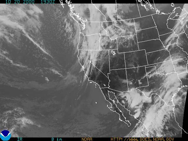 GOES 10 IR 10/20/2000 1930z |
Weathernotes for Friday, October 20, 2000An energetic "V" shaped trough is forecast to move into Northern and Central California today, plunge southward into Southern California tonight and tomorrow, and then close off into an upper low somewhere over southern California, northern Mexico or western Arizona later in the day on Saturday. Currently the system is resulting in generally moderate rain in far northern California, Oregon and Washington with isolated embedded thunderstorms and heavier rain in some areas. |
|
The main effect in Central and Southern California is expected to be cooler temperatures and the possibility of strong winds. At the moment computer models and forecasters are not especially bullish on the prospects for significant rain in the southern half of the state, but the system is continuing to evolve and there appears to be at least a chance of some scattered showers or light rain in the Kern River basin, with a chance of snow at higher elevations. We'll see! Models show another shortwave moving through the area mid week, but vary widely on their predictions. More information concerning Southern California weather can be found on our WEATHER LINKS page. |
|
 NOAA/CPC Winter Outlook 2000-2001 - Oct. 12,2000 |
Weathernotes for Monday, October 16, 2000NOAA/CPC has released their Winter Outlook for 2000-2001. Potential Winter Weather Impacts compared to 1998-2000 include slightly cooler weather over much of the West, and "enhanced possibilities" for heavy rain events from Northern California to Southern Alaska. More information concerning Southern California weather can be found on our WEATHER LINKS page. |
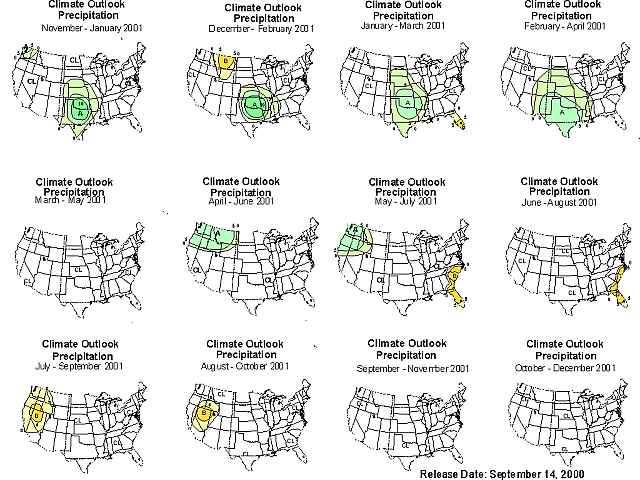 September Long Range Precipitation Forecast from CPC |
Weathernotes for Wednesday, October 11, 2000A broad upper level trough and low has brought the first significant precipitation of the rainy season to the region. Multiple disturbances rotating around the low and favorable orographics in some areas have resulted in variable amounts of rain and snow. According to remote sensors Kernville has received about 0.3 inch of rain, and Johnsondale about 1.3 inches. At the higher elevations of the Kern River basin Upper Tyndell Creek recorded about 0.8 inch water equivalent, and Pascoes about 1.7 inch water equivalent. Satellite and model data suggest another disturbance will rotate around the low and through the Sierra later today(image), with improving weather to follow. At the moment the weekend looks to be precipitation free. Following two years of La Nina influenced Winters, the ENSO state is currently near neutral. The September Long Range Precipitation Forecast, from the Climate Prediction Center predicts that precipitation in much of the West will be near climatological norms this Winter. The Winter 2000-2001 outlook, ENSO outlook, and additional climatological forecasts and data are scheduled for release over the next few days. More information concerning Southern California weather can be found on our WEATHER LINKS page. |
